TopoQuest Logo
Do you find TopoQuest useful?
Help keep TopoQuest running and adding new maps/features by donating!
Bitcoin:  19c7KJd3qBynnjoSw5npx9KScwjBe4ifkT
Litecoin:  LXs6TkuXGGXo1vDsWCkWVdjQX94eUKd6ui
Home View Maps Find Maps Find Places Resources & Links


Hualapai Flat South, Nevada Topographic Map

USGS Map Title: Hualapai Flat South, NV
USGS Map MRC: 40119G3
DRG (GeoTIFF) Download: o40119g3.tif


Neighboring USGS Topographic Map Quads:


  Melody Mountain, NV  
40119H4
 

  Hualapai Flat North, NV  
40119H3
 

  Mormon Dan Peak, NV  
40119H2
 

  The Banjo, NV  
40119G4
 

  Hualapai Flat South, NV  
40119G3
 

  Trego, NV  
40119G2
 

  Godeys Rock, NV  
40119F4
 

  Gerlach, NV  
40119F3
 

  Dry Mountain NW, NV  
40119F2


Map MRC Location:

N41°
W120°
N41°
W119°
H8 H7 H6 H5 H4 H3 H2 H1
G8 G7 G6 G5 G4 G3 G2 G1
F8 F7 F6 F5 F4 F3 F2 F1
E8 E7 E6 E5 E4 E3 E2 E1
D8 D7 D6 D5 D4 D3 D2 D1
C8 C7 C6 C5 C4 C3 C2 C1
B8 B7 B6 B5 B4 B3 B2 B1
A8 A7 A6 A5 A4 A3 A2 A1
N40°
W120°
N40°
W119°

Hualapai Flat South, NV USGS 1:24K Topographic Map Preview:
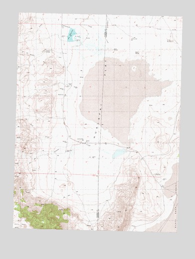
Hualapai Flat South, NV USGS Topographic Map
Click on map above to begin viewing in our Map Viewer.

This topographic map contains these locations and features:
Feature Name Type Latitude Longitude GNIS ID View Map
Bar W RanchLocaleN40.8680°W119.2927°856510View Map
Barker (historical)LocaleN40.8693°W119.3407°855317View Map
Barker CreekStreamN40.8593°W119.3430°850394View Map
Barker SpringsSpringN40.8541°W119.3516°850014View Map
Cottonwood CreekStreamN40.8613°W119.3380°839750View Map
Cottonwood SpringsSpringN40.8610°W119.3249°857047View Map
Finley ButteSummitN40.8607°W119.2594°850010View Map
Fly RanchLocaleN40.8330°W119.3355°850015View Map
Fly ReservoirReservoirN40.8626°W119.3355°858284View Map
Fly Reservoir DamDamN40.8632°W119.3360°863398View Map
Goose SpringsSpringN40.8552°W119.3032°850012View Map
Granite CreekStreamN40.7946°W119.3024°840745View Map
Granite Creek RanchLocaleN40.7955°W119.3374°856462View Map
Hot Springs (historical)Populated PlaceN40.8605°W119.3330°852827View Map
Hot Springs Post Office (historical)Post OfficeN40.8605°W119.3330°864777View Map
Hualapai FlatFlatN40.8743°W119.3002°850009View Map
John Casey Steam WellWellN40.8593°W119.3321°857083View Map
Little Cottonwood CreekStreamN40.8480°W119.3052°850395View Map
Red Mountain CreekStreamN40.8457°W119.3057°847203View Map
Rock CreekStreamN40.7988°W119.3319°843270View Map
South SpringsSpringN40.8538°W119.2871°850011View Map
South Willow CreekStreamN40.8396°W119.2941°838357View Map
The GeyserSpringN40.8614°W119.3329°850013View Map
The Geyser WellWellN40.8577°W119.3269°858590View Map
Wards (historical)LocaleN40.8041°W119.3363°846141View Map
Wards Hot SpringSpringN40.8587°W119.3253°857084View Map

Note: Coordinates in the location and feature list above are referenced to NAD83 datum.


Copyright (C) 2008-2025 Ryan Niemi / Sunset Dynamics ... All Rights Reserved