TopoQuest Logo
Do you find TopoQuest useful?
Help keep TopoQuest running and adding new maps/features by donating!
Bitcoin:  19c7KJd3qBynnjoSw5npx9KScwjBe4ifkT
Litecoin:  LXs6TkuXGGXo1vDsWCkWVdjQX94eUKd6ui
Home View Maps Find Maps Find Places Resources & Links


Hunters, Washington Topographic Map

USGS Map Title: Hunters, WA
USGS Map MRC: 48118A2
DRG (GeoTIFF) Download: o48118a2.tif


Neighboring USGS Topographic Map Quads:


  Kewa, WA  
48118B3
 

  Cedonia, WA  
48118B2
 

  Blackhorse Canyon, WA  
48118B1
 

  Miller Mountain, WA  
48118A3
 

  Hunters, WA  
48118A2
 

  Adams Mountain, WA  
48118A1
 

  Fort Spokane, WA  
47118H3
 

  McCoy Lake, WA  
47118H2
 

  Turtle Lake, WA  
47118H1


Map MRC Location:

N49°
W119°
N49°
W118°
H8 H7 H6 H5 H4 H3 H2 H1
G8 G7 G6 G5 G4 G3 G2 G1
F8 F7 F6 F5 F4 F3 F2 F1
E8 E7 E6 E5 E4 E3 E2 E1
D8 D7 D6 D5 D4 D3 D2 D1
C8 C7 C6 C5 C4 C3 C2 C1
B8 B7 B6 B5 B4 B3 B2 B1
A8 A7 A6 A5 A4 A3 A2 A1
N48°
W119°
N48°
W118°

Hunters, WA USGS 1:24K Topographic Map Preview:
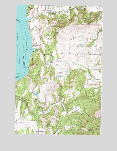
Hunters, WA USGS Topographic Map
Click on map above to begin viewing in our Map Viewer.

This topographic map contains these locations and features:
Feature Name Type Latitude Longitude GNIS ID View Map
Advent ChurchChurchN48.0721°W118.1611°1502946View Map
Alder CreekStreamN48.0813°W118.2203°1502967View Map
Boundary ButteSummitN48.0002°W118.1466°1503495View Map
Columbia Heights Assembly ChurchChurchN48.1129°W118.2013°2609546View Map
Columbia High and Elementary SchoolSchoolN48.1198°W118.2027°1515576View Map
Coyote CanyonValleyN48.0263°W118.1761°1504222View Map
EnterprisePopulated PlaceN48.0138°W118.2186°1514876View Map
Enterprise CemeteryCemeteryN48.0199°W118.2414°1504759View Map
Enterprise ChurchChurchN48.0129°W118.2194°1504761View Map
Enterprise ValleyValleyN48.0202°W118.2414°1504763View Map
FruitlandPopulated PlaceN48.0710°W118.1989°1510981View Map
H and B MineMineN48.0157°W118.1336°1505331View Map
Hunter CreekStreamN48.1127°W118.2272°1505675View Map
Hunter DamDamN48.1232°W118.1578°1531996View Map
HuntersPopulated PlaceN48.1168°W118.2019°1512314View Map
Hunters LandingLocaleN48.1177°W118.2342°1531789View Map
Hunters PondReservoirN48.1116°W118.2244°1532396View Map
Hunters Pond DamDamN48.1116°W118.2244°1532395View Map
Hunters Post OfficePost OfficeN48.1173°W118.2028°2769259View Map
Hunters Public LibraryBuildingN48.1163°W118.2039°2610161View Map
Mudgett LakeLakeN48.0390°W118.2192°1506880View Map
Newbill LakeLakeN48.0565°W118.1848°1506969View Map
Snook LakeReservoirN48.0074°W118.2295°1532022View Map
Snook Lake DamDamN48.0082°W118.2294°1532021View Map
Stevens County Fire District 2 Station 210BuildingN48.1180°W118.2002°2619872View Map
Stevens County Fire District 2 Station 230BuildingN48.0687°W118.1613°2619770View Map

Note: Coordinates in the location and feature list above are referenced to NAD83 datum.


Copyright (C) 2008-2025 Ryan Niemi / Sunset Dynamics ... All Rights Reserved