TopoQuest Logo
Do you find TopoQuest useful?
Help keep TopoQuest running and adding new maps/features by donating!
Bitcoin:  19c7KJd3qBynnjoSw5npx9KScwjBe4ifkT
Litecoin:  LXs6TkuXGGXo1vDsWCkWVdjQX94eUKd6ui
Home View Maps Find Maps Find Places Resources & Links


Baird, Texas Topographic Map

USGS Map Title: Baird, TX
USGS Map MRC: 32099D4
DRG (GeoTIFF) Download: o32099d4.tif


Neighboring USGS Topographic Map Quads:


  Flattop, TX  
32099E5
 

  Leeper Creek, TX  
32099E4
 

  Snyder Lake, TX  
32099E3
 

  Kirby Lake NE, TX  
32099D5
 

  Baird, TX  
32099D4
 

  Jayell, TX  
32099D3
 

  Eula, TX  
32099C5
 

  Club Hollow, TX  
32099C4
 

  Admiral, TX  
32099C3


Map MRC Location:

N33°
W100°
N33°
W99°
H8 H7 H6 H5 H4 H3 H2 H1
G8 G7 G6 G5 G4 G3 G2 G1
F8 F7 F6 F5 F4 F3 F2 F1
E8 E7 E6 E5 E4 E3 E2 E1
D8 D7 D6 D5 D4 D3 D2 D1
C8 C7 C6 C5 C4 C3 C2 C1
B8 B7 B6 B5 B4 B3 B2 B1
A8 A7 A6 A5 A4 A3 A2 A1
N32°
W100°
N32°
W99°

Baird, TX USGS 1:24K Topographic Map Preview:
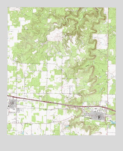
Baird, TX USGS Topographic Map
Click on map above to begin viewing in our Map Viewer.

This topographic map contains these locations and features:
Feature Name Type Latitude Longitude GNIS ID View Map
BairdPopulated PlaceN32.3940°W99.3942°1372371View Map
Baird City HallBuildingN32.3947°W99.3941°2753354View Map
Baird Elementary SchoolSchoolN32.3979°W99.3987°2003787View Map
Baird High SchoolSchoolN32.3982°W99.4031°2003788View Map
Baird Police DepartmentBuildingN32.3949°W99.3942°2750567View Map
Baird Post OfficePost OfficeN32.3939°W99.3961°2731879View Map
Baird QuarryMineN32.4536°W99.4092°2710007View Map
Baird Volunteer Fire DepartmentBuildingN32.3938°W99.3942°2551122View Map
Bell ParkParkN32.3990°W99.3923°1372489View Map
Callahan County CourthouseBuildingN32.3943°W99.3948°2030608View Map
Callahan County JailBuildingN32.3949°W99.3943°2738842View Map
Callahan County Pioneer MuseumBuildingN32.3940°W99.3942°2014261View Map
Callahan County Sheriff's OfficeBuildingN32.3951°W99.3940°2750223View Map
Church of GodChurchN32.3962°W99.4112°2016071View Map
Citizens Emergency Medical ServicesBuildingN32.4035°W99.4880°2656081View Map
City of BairdCivilN32.3960°W99.3962°2409771View Map
ClydePopulated PlaceN32.4060°W99.4937°1373147View Map
Clyde City HallBuildingN32.4081°W99.4939°2753132View Map
Clyde High SchoolSchoolN32.4032°W99.4923°2003790View Map
Clyde Junior High SchoolSchoolN32.4021°W99.4906°2003792View Map
Clyde Police DepartmentBuildingN32.4074°W99.4939°2750487View Map
Clyde Post OfficePost OfficeN32.4115°W99.4964°2731229View Map
First Presbyterian ChurchChurchN32.3940°W99.3904°2016072View Map
Latimer LakeReservoirN32.3840°W99.4311°1864631View Map
Latimer Lake DamDamN32.3851°W99.4287°1864630View Map
Ross CemeteryCemeteryN32.4071°W99.3845°1375827View Map
Saint Joachim CemeteryCemeteryN32.3862°W99.4804°1375895View Map
T P LakeReservoirN32.3879°W99.3761°1376363View Map
The Bears Den StadiumParkN32.3996°W99.4004°2027616View Map

Note: Coordinates in the location and feature list above are referenced to NAD83 datum.


Copyright (C) 2008-2025 Ryan Niemi / Sunset Dynamics ... All Rights Reserved