TopoQuest Logo
Do you find TopoQuest useful?
Help keep TopoQuest running and adding new maps/features by donating!
Bitcoin:  19c7KJd3qBynnjoSw5npx9KScwjBe4ifkT
Litecoin:  LXs6TkuXGGXo1vDsWCkWVdjQX94eUKd6ui
Home View Maps Find Maps Find Places Resources & Links


Independence Pass, Colorado Topographic Map

USGS Map Title: Independence Pass, CO
USGS Map MRC: 39106A5
DRG (GeoTIFF) Download: o39106a5.tif


Neighboring USGS Topographic Map Quads:


  Thimble Rock, CO  
39106B6
 

  Mount Champion, CO  
39106B5
 

  Mount Massive, CO  
39106B4
 

  New York Peak, CO  
39106A6
 

  Independence Pass, CO  
39106A5
 

  Mount Elbert, CO  
39106A4
 

  Italian Creek, CO  
38106H6
 

  Pieplant, CO  
38106H5
 

  Winfield, CO  
38106H4


Map MRC Location:

N40°
W107°
N40°
W106°
H8 H7 H6 H5 H4 H3 H2 H1
G8 G7 G6 G5 G4 G3 G2 G1
F8 F7 F6 F5 F4 F3 F2 F1
E8 E7 E6 E5 E4 E3 E2 E1
D8 D7 D6 D5 D4 D3 D2 D1
C8 C7 C6 C5 C4 C3 C2 C1
B8 B7 B6 B5 B4 B3 B2 B1
A8 A7 A6 A5 A4 A3 A2 A1
N39°
W107°
N39°
W106°

Independence Pass, CO USGS 1:24K Topographic Map Preview:
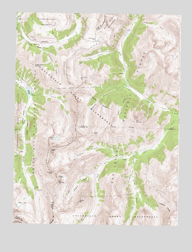
Independence Pass, CO USGS Topographic Map
Click on map above to begin viewing in our Map Viewer.

This topographic map contains these locations and features:
Feature Name Type Latitude Longitude GNIS ID View Map
Brumley (historical)Populated PlaceN39.0894°W106.5428°180336View Map
Bwlchgoch MineMineN39.0333°W106.5500°1684873View Map
Continental DivideRidgeN39.0003°W106.5973°205015View Map
Detroit MineMineN39.0167°W106.5506°1684874View Map
EverettPopulated PlaceN39.0678°W106.5020°180345View Map
Galena CreekStreamN39.0428°W106.6173°180317View Map
Garfield PeakSummitN39.0305°W106.5948°180364View Map
Graham GulchValleyN39.0821°W106.5396°180349View Map
Grizzly CreekStreamN39.0772°W106.6134°180352View Map
Grizzly LakeLakeN39.0506°W106.5942°180351View Map
Grizzly PeakSummitN39.0425°W106.5975°180350View Map
Grizzly ReservoirReservoirN39.0777°W106.6147°180354View Map
Grizzly Reservoir DamDamN39.0797°W106.6164°200604View Map
Henschel LakeLakeN39.0282°W106.5872°180356View Map
Independence (historical)Populated PlaceN39.1072°W106.6059°180342View Map
Independence CreekStreamN39.1053°W106.6053°180341View Map
Independence MountainSummitN39.0942°W106.6111°180340View Map
Independence PassGapN39.1089°W106.5639°180339View Map
Lackawanna GulchValleyN39.1185°W106.5350°180335View Map
Lincoln Mining District MineMineN39.0153°W106.6061°1684877View Map
Lone Star MineMineN39.1155°W106.5273°1684886View Map
McNasser GulchValleyN39.0404°W106.5484°180358View Map
Middle MountainSummitN39.0128°W106.5759°180359View Map
Mountain Boy GulchValleyN39.1017°W106.5485°180338View Map
Mountain Boy MineMineN39.0925°W106.5731°1684875View Map
Mountain Boy ParkFlatN39.0867°W106.5756°180337View Map
Negro GulchValleyN39.0794°W106.5369°180348View Map
Ouray PeakSummitN39.0542°W106.5650°180347View Map
Peekaboo GulchValleyN39.0304°W106.5631°180360View Map
Portal CampgroundLocaleN39.0764°W106.6125°180353View Map
Red MountainSummitN39.0244°W106.5917°180357View Map
Ruby (historical)Populated PlaceN39.0208°W106.6092°180362View Map
Ruby LakesLakeN39.0136°W106.6184°180361View Map
Ruby MineMineN39.0200°W106.6045°180363View Map
Saturday Night MineMineN39.0978°W106.5745°1684876View Map
Sayres GulchValleyN39.0425°W106.5310°180365View Map
South Fork Lake CreekStreamN39.0655°W106.5000°180366View Map
Star MountainSummitN39.0617°W106.5334°180346View Map
The Burge Group MineMineN39.0333°W106.5673°1684872View Map
Truro CreekStreamN39.0636°W106.6195°180318View Map
Twin Lakes Reservoir and Canal Company Tunnel Number 1TunnelN39.0806°W106.5772°180355View Map
Wet GulchValleyN39.1067°W106.5942°180343View Map

Note: Coordinates in the location and feature list above are referenced to NAD83 datum.


Copyright (C) 2008-2024 Ryan Niemi / Sunset Dynamics ... All Rights Reserved