TopoQuest Logo
Do you find TopoQuest useful?
Help keep TopoQuest running and adding new maps/features by donating!
Bitcoin:  19c7KJd3qBynnjoSw5npx9KScwjBe4ifkT
Litecoin:  LXs6TkuXGGXo1vDsWCkWVdjQX94eUKd6ui
Home View Maps Find Maps Find Places Resources & Links


Island Park Dam, Idaho Topographic Map

USGS Map Title: Island Park Dam, ID
USGS Map MRC: 44111D4
DRG (GeoTIFF) Download: o44111d4.tif


Neighboring USGS Topographic Map Quads:


  Mount Jefferson, MT  
44111E5
 

  Sawtell Peak, ID  
44111E4
 

  Big Springs, ID  
44111E3
 

  Icehouse Creek, ID  
44111D5
 

  Island Park Dam, ID  
44111D4
 

  Island Park, ID  
44111D3
 

  Bishop Mountain, ID  
44111C5
 

  Last Chance, ID  
44111C4
 

  Hatchery Butte, ID  
44111C3


Map MRC Location:

N45°
W112°
N45°
W111°
H8 H7 H6 H5 H4 H3 H2 H1
G8 G7 G6 G5 G4 G3 G2 G1
F8 F7 F6 F5 F4 F3 F2 F1
E8 E7 E6 E5 E4 E3 E2 E1
D8 D7 D6 D5 D4 D3 D2 D1
C8 C7 C6 C5 C4 C3 C2 C1
B8 B7 B6 B5 B4 B3 B2 B1
A8 A7 A6 A5 A4 A3 A2 A1
N44°
W112°
N44°
W111°

Island Park Dam, ID USGS 1:24K Topographic Map Preview:
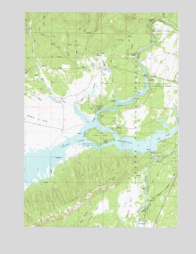
Island Park Dam, ID USGS Topographic Map
Click on map above to begin viewing in our Map Viewer.

This topographic map contains these locations and features:
Feature Name Type Latitude Longitude GNIS ID View Map
Antelope ParkFlatN44.3874°W111.4141°376657View Map
Arange CreekStreamN44.4863°W111.4825°376690View Map
Blind CreekStreamN44.4483°W111.4605°377856View Map
Blue CreekStreamN44.4483°W111.4605°377898View Map
Box CanyonValleyN44.3752°W111.4077°378138View Map
Box CanyonPopulated PlaceN44.3788°W111.4055°396172View Map
Buffalo RiverStreamN44.4141°W111.3938°378447View Map
Buttermilk CampgroundLocaleN44.4335°W111.4250°378616View Map
Coffee Pot CreekStreamN44.4888°W111.3986°379494View Map
Coffee Pot RapidsRapidsN44.4959°W111.3950°379495View Map
Crow CreekStreamN44.4246°W111.3975°380099View Map
Dry CreekStreamN44.4519°W111.4805°380824View Map
East Fork Hotel CreekStreamN44.4713°W111.4602°381115View Map
Elk Springs CreekStreamN44.4738°W111.4108°381397View Map
Harrison SpringSpringN44.4755°W111.4103°382937View Map
Hotel CreekStreamN44.4483°W111.4602°383458View Map
I P Bills IslandIslandN44.4277°W111.4391°383588View Map
Island Park DamDamN44.4188°W111.3963°383783View Map
Island Park Fire Department Station 3BuildingN44.4659°W111.4385°2619249View Map
Jackson Landing CampgroundLocaleN44.4460°W111.4372°399004View Map
Lower Coffee Pot CampgroundLocaleN44.4905°W111.3980°386219View Map
McCrea Bridge CampgroundLocaleN44.4624°W111.4000°396866View Map
McCrea RanchLocaleN44.4533°W111.4091°386595View Map
Mill CreekStreamN44.4521°W111.4275°386922View Map
Mill Creek CampgroundLocaleN44.4485°W111.4263°386951View Map
ReaPopulated PlaceN44.4696°W111.4352°394979View Map
Sheep CreekStreamN44.4452°W111.4613°390209View Map
Shotgun ValleyValleyN44.4283°W111.4691°390387View Map
Tyler CreekStreamN44.4963°W111.3894°392578View Map
West Fork Hotel CreekStreamN44.4758°W111.4663°393119View Map
West Fork Mill CreekStreamN44.4636°W111.4295°2785893View Map
Yale CreekStreamN44.4633°W111.4455°393733View Map

Note: Coordinates in the location and feature list above are referenced to NAD83 datum.


Copyright (C) 2008-2025 Ryan Niemi / Sunset Dynamics ... All Rights Reserved