TopoQuest Logo
Do you find TopoQuest useful?
Help keep TopoQuest running and adding new maps/features by donating!
Bitcoin:  19c7KJd3qBynnjoSw5npx9KScwjBe4ifkT
Litecoin:  LXs6TkuXGGXo1vDsWCkWVdjQX94eUKd6ui
Home View Maps Find Maps Find Places Resources & Links


Jacksonville South, North Carolina Topographic Map

USGS Map Title: Jacksonville South, NC
USGS Map MRC: 34077F4
DRG (GeoTIFF) Download: o34077f4.tif


Neighboring USGS Topographic Map Quads:


  Catherine Lake, NC  
34077G5
 

  Jacksonville North, NC  
34077G4
 

  Kellum, NC  
34077G3
 

  Haws Run, NC  
34077F5
 

  Jacksonville South, NC  
34077F4
 

  Camp Lejeune, NC  
34077F3
 

  Folkstone, NC  
34077E5
 

  Sneads Ferry, NC  
34077E4
 

  New River Inlet, NC  
34077E3


Map MRC Location:

N35°
W78°
N35°
W77°
H8 H7 H6 H5 H4 H3 H2 H1
G8 G7 G6 G5 G4 G3 G2 G1
F8 F7 F6 F5 F4 F3 F2 F1
E8 E7 E6 E5 E4 E3 E2 E1
D8 D7 D6 D5 D4 D3 D2 D1
C8 C7 C6 C5 C4 C3 C2 C1
B8 B7 B6 B5 B4 B3 B2 B1
A8 A7 A6 A5 A4 A3 A2 A1
N34°
W78°
N34°
W77°

Jacksonville South, NC USGS 1:24K Topographic Map Preview:
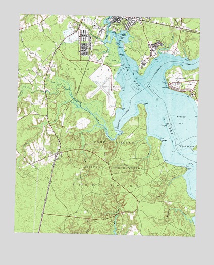
Jacksonville South, NC USGS Topographic Map
Click on map above to begin viewing in our Map Viewer.

This topographic map contains these locations and features:
Feature Name Type Latitude Longitude GNIS ID View Map
Bay ChurchChurchN34.6657°W77.4866°980650View Map
BayshorePopulated PlaceN34.7452°W77.4250°1003123View Map
Briar Creek Mobile Home ParkPopulated PlaceN34.7458°W77.4973°2505419View Map
Brinson CreekStreamN34.7346°W77.4402°981914View Map
Bryan Mobile Home ParkPopulated PlaceN34.6929°W77.4923°2505421View Map
Brynn Marr Shopping CenterLocaleN34.7471°W77.3866°1007677View Map
Camp Lejeune Fire DepartmentBuildingN34.7333°W77.4056°2639322View Map
Camp Lejeune Fire DepartmentBuildingN34.7183°W77.4442°2639333View Map
Camp Lejeune Fire DepartmentBuildingN34.7338°W77.4574°2639337View Map
Camp Lejeune Fire DepartmentBuildingN34.7091°W77.3781°2639340View Map
City of JacksonvilleCivilN34.7323°W77.3962°2404784View Map
Coastal Carolina State Veterans CemeteryCemeteryN34.7470°W77.4177°2773422View Map
Edwards CreekStreamN34.7349°W77.4394°984660View Map
Ethridge PointCapeN34.7399°W77.4350°1027485View Map
Faith Body of Christ Assembly ChurchChurchN34.7465°W77.4311°2505811View Map
Frenchmans PointCapeN34.7285°W77.3914°1003144View Map
GeorgetownPopulated PlaceN34.7413°W77.4430°1003148View Map
Gerogetown High SchoolSchoolN34.7446°W77.4472°985641View Map
Hadnot PointCapeN34.6749°W77.3769°986281View Map
Hicks RunStreamN34.6974°W77.4552°986727View Map
Holmes PointCapeN34.6796°W77.4005°986974View Map
Jacks PointCapeN34.7329°W77.4308°987483View Map
Jacksonville CemeteryCemeteryN34.7492°W77.4154°1003122View Map
Jacksonville Post OfficePost OfficeN34.7499°W77.4222°2505375View Map
Kingdom Hall of Jehovahs WitnessesChurchN34.7397°W77.4821°2506102View Map
Knox AreaPopulated PlaceN34.7318°W77.3908°1003161View Map
Knox Trailer ParkPopulated PlaceN34.7441°W77.3891°1003124View Map
Lewis CreekStreamN34.6821°W77.4086°988392View Map
Lutheran Church of Our SaviorChurchN34.7474°W77.4052°2505507View Map
McCutcheon Field Post OfficePost OfficeN34.7238°W77.4492°2780608View Map
Mill RunStreamN34.6835°W77.4377°989981View Map
Momford LandingPopulated PlaceN34.7277°W77.4058°1003162View Map
Montford PointPopulated PlaceN34.7243°W77.4144°1003145View Map
Mount Sinai Holy ChurchChurchN34.7473°W77.4304°2505706View Map
Mumford PointCapeN34.7193°W77.4161°990793View Map
New River Marine Corps Air Station /H/ /McCutcheon FieldAirportN34.7165°W77.4441°1023381View Map
North Carolina State Highway Patrol Troop B District 3BuildingN34.7466°W77.4555°2130874View Map
Northeast CreekStreamN34.7141°W77.4077°1025586View Map
Onslow CountyCivilN34.7098°W77.4158°1026341View Map
Onslow County Emergency Medical Services Station 2BuildingN34.7267°W77.4852°2720465View Map
Onslow County Health DepartmentBuildingN34.7483°W77.4257°2505783View Map
Onslow County Recreation ParkParkN34.7268°W77.4855°1003129View Map
Paradise IslandIslandN34.7154°W77.3825°1008303View Map
Paradise ParkPopulated PlaceN34.7310°W77.4766°1003130View Map
Paradise PointCapeN34.7135°W77.3964°991845View Map
Paradise PointLocaleN34.7082°W77.3772°1003147View Map
Plum Point EstatesPopulated PlaceN34.7366°W77.4833°1003131View Map
Praise Gospel AssemblyChurchN34.7500°W77.4461°2506229View Map
Ragged PointCapeN34.6993°W77.4119°992986View Map
Saint Julia African Methodist Episcopal Zion ChurchChurchN34.7470°W77.4336°2505650View Map
Scales CreekStreamN34.7299°W77.4008°994405View Map
South Gate Mobile Home ParkPopulated PlaceN34.7355°W77.4710°2505656View Map
Southwest CreekStreamN34.7041°W77.4200°1025720View Map
Springdale AcresPopulated PlaceN34.7438°W77.4825°1003132View Map
Stick CreekStreamN34.7238°W77.4289°995510View Map
Strawhorn CreekGutN34.7271°W77.4408°995609View Map
Tank CreekStreamN34.7104°W77.4714°995838View Map
Tarawa Terrace Elementary SchoolSchoolN34.7324°W77.3783°1003106View Map
Tarawa Terrace IIPopulated PlaceN34.7338°W77.3786°1003134View Map
Town CreekStreamN34.6599°W77.3844°996179View Map
Town PointCapeN34.6641°W77.3819°996188View Map
Trent River Missionary Baptist ChurchChurchN34.7434°W77.4427°2506284View Map
Utopia Mobile Home ParkPopulated PlaceN34.7371°W77.4794°1003143View Map
VeronaPopulated PlaceN34.6696°W77.4716°996610View Map
Verona Free Will Baptist ChurchChurchN34.6706°W77.4715°2506300View Map
Verona United Methodist ChurchChurchN34.6707°W77.4701°2506301View Map
Verona Volunteer Fire DepartmentBuildingN34.6695°W77.4720°2639433View Map
Walter M Thompson Elementary SchoolSchoolN34.7485°W77.4289°1024866View Map
Whitside BranchStreamN34.7038°W77.3780°1001119View Map
Wilson BayBayN34.7377°W77.4297°997431View Map
Wilson Bay ParkParkN34.7418°W77.4258°1001117View Map
Wilson IslandIslandN34.7404°W77.4252°997454View Map
Wilsons BluffCliffN34.7435°W77.4366°1018692View Map
WJIK-AM (Camp Lejeune)TowerN34.7341°W77.4911°1018366View Map
WJNC-AM (Jacksonville)TowerN34.7491°W77.4139°1018368View Map
Word of Life Fellowship ChurchChurchN34.7450°W77.3879°2506320View Map
WRCM-FM (Jacksonville)TowerN34.7491°W77.4139°1018621View Map

Note: Coordinates in the location and feature list above are referenced to NAD83 datum.


Copyright (C) 2008-2025 Ryan Niemi / Sunset Dynamics ... All Rights Reserved