TopoQuest Logo
Do you find TopoQuest useful?
Help keep TopoQuest running and adding new maps/features by donating!
Bitcoin:  19c7KJd3qBynnjoSw5npx9KScwjBe4ifkT
Litecoin:  LXs6TkuXGGXo1vDsWCkWVdjQX94eUKd6ui
Home View Maps Find Maps Find Places Resources & Links


Jefferson, South Dakota Topographic Map

USGS Map Title: Jefferson, SD
USGS Map MRC: 42096E5
DRG (GeoTIFF) Download: o42096e5.tif


Neighboring USGS Topographic Map Quads:


  Elk Point, SD  
42096F6
 

  Elk Point NE, IA  
42096F5
 

  Millnerville, IA  
42096F4
 

  Ponca, NE  
42096E6
 

  Jefferson, SD  
42096E5
 

  Sioux City North, IA  
42096E4
 

  Waterbury, NE  
42096D6
 

  Jackson, NE  
42096D5
 

  Sioux City South, IA  
42096D4


Map MRC Location:

N43°
W97°
N43°
W96°
H8 H7 H6 H5 H4 H3 H2 H1
G8 G7 G6 G5 G4 G3 G2 G1
F8 F7 F6 F5 F4 F3 F2 F1
E8 E7 E6 E5 E4 E3 E2 E1
D8 D7 D6 D5 D4 D3 D2 D1
C8 C7 C6 C5 C4 C3 C2 C1
B8 B7 B6 B5 B4 B3 B2 B1
A8 A7 A6 A5 A4 A3 A2 A1
N42°
W97°
N42°
W96°

Jefferson, SD USGS 1:24K Topographic Map Preview:
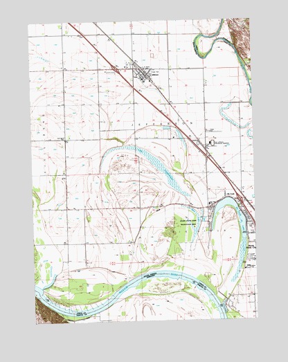
Jefferson, SD USGS Topographic Map
Click on map above to begin viewing in our Map Viewer.

This topographic map contains these locations and features:
Feature Name Type Latitude Longitude GNIS ID View Map
City of JeffersonCivilN42.6043°W96.5661°1267441View Map
Civil Bend CemeteryCemeteryN42.5769°W96.6064°1254365View Map
Civil Bend SchoolSchoolN42.5758°W96.6064°1254366View Map
Dakota Valley Elementary SchoolSchoolN42.5515°W96.5186°2728559View Map
Dakota Valley High SchoolSchoolN42.5490°W96.5254°2728560View Map
Dakota Valley Junior High SchoolSchoolN42.5490°W96.5254°2728561View Map
Dakota Valley Upper Elementary SchoolSchoolN42.5490°W96.5254°2728562View Map
Gibson SchoolSchoolN42.5828°W96.5267°1255241View Map
Interchange 4CrossingN42.5502°W96.5088°2725642View Map
Interchange 9CrossingN42.6052°W96.5768°2725644View Map
Island SchoolSchoolN42.5472°W96.5653°1255793View Map
JeffersonPopulated PlaceN42.6025°W96.5592°1255817View Map
Jefferson Ambulance ServiceBuildingN42.6033°W96.5620°2658932View Map
Jefferson City HallBuildingN42.6023°W96.5584°2725080View Map
Jefferson Police DepartmentBuildingN42.6024°W96.5584°2755558View Map
Jefferson Post OfficePost OfficeN42.6027°W96.5595°2710401View Map
Jefferson Volunteer Fire DepartmentBuildingN42.6030°W96.5616°2580656View Map
Kenslers Bend (historical)BendN42.5072°W96.5845°1263487View Map
Lake GoodenoughSwampN42.5667°W96.5567°1265231View Map
McCook LakePopulated PlaceN42.5417°W96.5059°1265095View Map
McCook LakeLakeN42.5491°W96.5152°1256367View Map
McCook LakeLocaleN42.5417°W96.5253°1259258View Map
Mud LakeSwampN42.5409°W96.5373°1256608View Map
North Sioux City Fire DepartmentBuildingN42.5265°W96.5027°2580711View Map
Park Jefferson RacetrackLocaleN42.5739°W96.5231°1256951View Map
Saint Peter's CemeteryCemeteryN42.6045°W96.5598°2779397View Map
Sodrac ParkParkN42.5214°W96.5048°1258149View Map
Township of Big SiouxCivilN42.5231°W96.5087°1729726View Map
Township of Bix SiouxCivilN42.5542°W96.5378°1268995View Map
Township of JeffersonCivilN42.5852°W96.5618°1268996View Map

Note: Coordinates in the location and feature list above are referenced to NAD83 datum.


Copyright (C) 2008-2024 Ryan Niemi / Sunset Dynamics ... All Rights Reserved