TopoQuest Logo
Do you find TopoQuest useful?
Help keep TopoQuest running and adding new maps/features by donating!
Bitcoin:  19c7KJd3qBynnjoSw5npx9KScwjBe4ifkT
Litecoin:  LXs6TkuXGGXo1vDsWCkWVdjQX94eUKd6ui
Home View Maps Find Maps Find Places Resources & Links


Jerome, Idaho Topographic Map

USGS Map Title: Jerome, ID
USGS Map MRC: 42114F5
DRG (GeoTIFF) Download: o42114f5.tif


Neighboring USGS Topographic Map Quads:


  Wendell, ID  
42114G6
 

  Gooding SE, ID  
42114G5
 

  Shoshone SW, ID  
42114G4
 

  Niagara Springs, ID  
42114F6
 

  Jerome, ID  
42114F5
 

  Falls City, ID  
42114F4
 

  Clover, ID  
42114E6
 

  Filer, ID  
42114E5
 

  Twin Falls, ID  
42114E4


Map MRC Location:

N43°
W115°
N43°
W114°
H8 H7 H6 H5 H4 H3 H2 H1
G8 G7 G6 G5 G4 G3 G2 G1
F8 F7 F6 F5 F4 F3 F2 F1
E8 E7 E6 E5 E4 E3 E2 E1
D8 D7 D6 D5 D4 D3 D2 D1
C8 C7 C6 C5 C4 C3 C2 C1
B8 B7 B6 B5 B4 B3 B2 B1
A8 A7 A6 A5 A4 A3 A2 A1
N42°
W115°
N42°
W114°

Jerome, ID USGS 1:24K Topographic Map Preview:
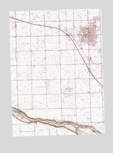
Jerome, ID USGS Topographic Map
Click on map above to begin viewing in our Map Viewer.

This topographic map contains these locations and features:
Feature Name Type Latitude Longitude GNIS ID View Map
Alpheus CreekStreamN42.6305°W114.5184°399417View Map
Appleton SchoolSchoolN42.7235°W114.6173°371279View Map
Auger FallsFallsN42.6321°W114.5273°371308View Map
Auger Falls Access AreaLocaleN42.6324°W114.5262°401206View Map
Camozzi ParkParkN42.7388°W114.5112°395725View Map
Candlelight ParkParkN42.7130°W114.5109°395726View Map
Canyonside Christian SchoolSchoolN42.7106°W114.5059°371884View Map
Central Elementary SchoolSchoolN42.7263°W114.5192°401268View Map
Central Elementary SchoolSchoolN42.7266°W114.5189°395729View Map
City of JeromeCivilN42.7184°W114.5159°2410140View Map
Ellisons SpringSpringN42.6399°W114.5745°399501View Map
Gayle Forsyth Memorial ParkParkN42.7321°W114.5048°395741View Map
Haytown (historical)Populated PlaceN42.6927°W114.5023°396635View Map
HydraPopulated PlaceN42.6994°W114.5189°373194View Map
Idaho Department of Fish and GameBuildingN42.7221°W114.5059°395759View Map
Idaho National GuardBuildingN42.7255°W114.5275°395761View Map
Jefferson Elementary SchoolSchoolN42.7291°W114.5084°395762View Map
JeromePopulated PlaceN42.7241°W114.5187°396706View Map
Jerome City Fire Department Station 1BuildingN42.7234°W114.5171°2618994View Map
Jerome City Fire Department Station 2BuildingN42.6954°W114.5195°2619157View Map
Jerome City Fire Department Station 3BuildingN42.7233°W114.5181°2619153View Map
Jerome City HallBuildingN42.7235°W114.5170°401644View Map
Jerome City Police DepartmentBuildingN42.7234°W114.5182°2722404View Map
Jerome Country ClubLocaleN42.6355°W114.5114°400279View Map
Jerome County CourthouseBuildingN42.7266°W114.5181°401645View Map
Jerome County FairgroundsLocaleN42.7269°W114.5289°395528View Map
Jerome County FairgroundsLocaleN42.7271°W114.5287°401646View Map
Jerome County Historical MuseumBuildingN42.7257°W114.5181°395764View Map
Jerome County ParamedicsBuildingN42.7244°W114.5157°2642840View Map
Jerome County Sheriff's OfficeBuildingN42.7265°W114.5180°2722432View Map
Jerome Early Education CenterSchoolN42.7197°W114.5180°400697View Map
Jerome Game FarmLocaleN42.7082°W114.5056°401520View Map
Jerome Middle SchoolSchoolN42.7274°W114.5203°401515View Map
Jerome Middle SchoolSchoolN42.7274°W114.5193°401647View Map
Jerome Post OfficePost OfficeN42.7254°W114.5170°2781758View Map
Jerome Rural Fire DistrictBuildingN42.7229°W114.5175°2619158View Map
Jerome StationLocaleN42.7241°W114.5423°373310View Map
KART-AM (Jerome)TowerN42.7307°W114.5389°401846View Map
Lateral J-17CanalN42.7333°W114.5390°2568943View Map
Lateral J-2CanalN42.7386°W114.5453°2568944View Map
Lateral J-3CanalN42.7154°W114.5948°2568945View Map
Lateral L-10CanalN42.7149°W114.5160°2568951View Map
Lateral L-11CanalN42.6899°W114.5092°2568952View Map
Lateral L-12CanalN42.7023°W114.5148°2568953View Map
Lateral L-13CanalN42.7204°W114.5039°2568954View Map
Lateral L-14CanalN42.6805°W114.5026°2568955View Map
Lateral L-15CanalN42.7167°W114.5014°2568957View Map
Lateral L-31CanalN42.7132°W114.5184°2568972View Map
Lateral L-34CanalN42.7019°W114.5285°2568973View Map
Lateral L-37CanalN42.7287°W114.5018°2568974View Map
Lateral L-8CanalN42.6772°W114.5070°2568977View Map
Lateral L-9CanalN42.6601°W114.5012°2568978View Map
Lateral M-2CanalN42.7436°W114.5041°2568980View Map
Lateral M-3CanalN42.7373°W114.5151°2568981View Map
Lateral M-4CanalN42.7423°W114.5022°2568982View Map
Lateral M-5CanalN42.7458°W114.5137°2568983View Map
Lateral N-1CanalN42.7262°W114.5474°2568986View Map
Lateral N-15CanalN42.7104°W114.5681°2568988View Map
Lateral N-17CanalN42.7007°W114.5609°2568989View Map
Lateral N-20CanalN42.6989°W114.5425°2568990View Map
Lateral N-22CanalN42.6874°W114.5305°2568991View Map
Lateral N-24CanalN42.6571°W114.5663°2568993View Map
Lateral N-25CanalN42.6740°W114.5439°2568994View Map
Lateral N-29CanalN42.6549°W114.5962°2568995View Map
Lateral N-3CanalN42.7129°W114.5520°2568996View Map
Lateral N-30CanalN42.6552°W114.5363°2568997View Map
Lateral N-33CanalN42.6488°W114.5057°2569002View Map
Lateral N-34CanalN42.6423°W114.5235°2569003View Map
Lateral N-37CanalN42.6795°W114.5568°2569004View Map
Lateral N-4CanalN42.6926°W114.5599°2569005View Map
Lateral N-41CanalN42.6476°W114.5185°2569006View Map
Lateral N-43CanalN42.6764°W114.5281°2569007View Map
Lateral N-44CanalN42.7096°W114.5454°2569008View Map
Lateral N-45CanalN42.7205°W114.5416°2569009View Map
Lateral N-5CanalN42.6877°W114.5710°2569010View Map
Lateral N-7CanalN42.6951°W114.5790°2569011View Map
Lateral N-8CanalN42.6772°W114.5846°2569012View Map
Lateral N-9CanalN42.6705°W114.5941°2569013View Map
Lateral N32CanalN42.6544°W114.5266°2568998View Map
Lateral S-1CanalN42.7471°W114.5476°2569040View Map
Lateral S-14CanalN42.7369°W114.5764°2569123View Map
Lateral S-15CanalN42.7295°W114.5697°2569124View Map
Lateral S-17CanalN42.7269°W114.5981°2569125View Map
Lateral S-18CanalN42.7205°W114.5955°2569126View Map
Lateral S-43CanalN42.7481°W114.5283°2569138View Map
Lateral S-6CanalN42.7464°W114.6137°2569140View Map
M Canal WasteCanalN42.7332°W114.5157°2569204View Map
N CanalCanalN42.6961°W114.5306°2569207View Map
Rock CreekStreamN42.6324°W114.5389°395876View Map
Saint Luke's Jerome Medical CenterHospitalN42.7301°W114.5193°395798View Map
Sonnickson ButteSummitN42.6699°W114.5470°375123View Map
Warm CreekStreamN42.6257°W114.5081°375731View Map
Ziggy's AirportAirportN42.6423°W114.6076°2443842View Map

Note: Coordinates in the location and feature list above are referenced to NAD83 datum.


Copyright (C) 2008-2024 Ryan Niemi / Sunset Dynamics ... All Rights Reserved