TopoQuest Logo
Do you find TopoQuest useful?
Help keep TopoQuest running and adding new maps/features by donating!
Bitcoin:  19c7KJd3qBynnjoSw5npx9KScwjBe4ifkT
Litecoin:  LXs6TkuXGGXo1vDsWCkWVdjQX94eUKd6ui
Home View Maps Find Maps Find Places Resources & Links


Jones Crossroads, Alabama Topographic Map

USGS Map Title: Jones Crossroads, AL
USGS Map MRC: 34087F1
DRG (GeoTIFF) Download: o34087f1.tif


Neighboring USGS Topographic Map Quads:


  Cairo, AL  
34087G2
 

  Ripley, AL  
34087G1
 

  Athens, AL  
34086G8
 

  Hillsboro, AL  
34087F2
 

  Jones Crossroads, AL  
34087F1
 

  Tanner, AL  
34086F8
 

  Caddo, AL  
34087E2
 

  Trinity, AL  
34087E1
 

  Decatur, AL  
34086E8


Map MRC Location:

N35°
W88°
N35°
W87°
H8 H7 H6 H5 H4 H3 H2 H1
G8 G7 G6 G5 G4 G3 G2 G1
F8 F7 F6 F5 F4 F3 F2 F1
E8 E7 E6 E5 E4 E3 E2 E1
D8 D7 D6 D5 D4 D3 D2 D1
C8 C7 C6 C5 C4 C3 C2 C1
B8 B7 B6 B5 B4 B3 B2 B1
A8 A7 A6 A5 A4 A3 A2 A1
N34°
W88°
N34°
W87°

Jones Crossroads, AL USGS 1:24K Topographic Map Preview:
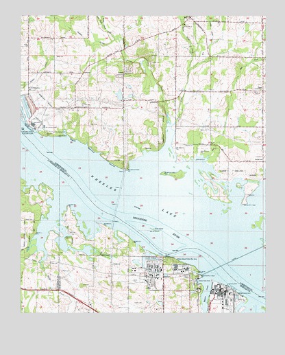
Jones Crossroads, AL USGS Topographic Map
Click on map above to begin viewing in our Map Viewer.

This topographic map contains these locations and features:
Feature Name Type Latitude Longitude GNIS ID View Map
Baker CemeteryCemeteryN34.6640°W87.1228°113375View Map
Baker CemeteryCemeteryN34.6709°W87.1181°113376View Map
Bakers CreekStreamN34.6393°W87.0292°113394View Map
Beckham BranchStreamN34.7401°W87.0767°113780View Map
Bell ChurchChurchN34.6306°W87.0531°151672View Map
Bells School (historical)SchoolN34.6659°W87.0906°139699View Map
Benford CemeteryCemeteryN34.7098°W87.0897°148817View Map
Bethlehem CemeteryCemeteryN34.7109°W87.0550°148816View Map
Bethlehem ChurchChurchN34.7137°W87.0550°151681View Map
Beulah BayBayN34.6751°W87.0158°138653View Map
Beulah LandPopulated PlaceN34.6887°W87.0014°156062View Map
Beulah Land Fishing Camp (historical)LocaleN34.6812°W87.0172°138654View Map
Binford CemeteryCemeteryN34.7037°W87.0897°114352View Map
Bridgeforth CemeteryCemeteryN34.6776°W87.0133°148815View Map
Bridgeforth FarmsLocaleN34.6894°W87.0197°2630510View Map
Briley CreekStreamN34.7040°W87.0472°114917View Map
Browns Ferry (historical)CrossingN34.7009°W87.1242°136735View Map
Browns Ferry Nuclear PlantLocaleN34.7044°W87.1189°164295View Map
Broyles BranchStreamN34.7081°W87.0436°138656View Map
Burt CemeteryCemeteryN34.6543°W87.0778°115280View Map
Byrd Island BarBarN34.6518°W87.0411°137804View Map
Cox CemeteryCemeteryN34.7109°W87.1044°116781View Map
Decatur State DocksLocaleN34.6381°W87.0342°117187View Map
Dry CreekStreamN34.7459°W87.0836°117592View Map
Elliott CemeteryCemeteryN34.6351°W87.1103°117941View Map
Ezekiel ChurchChurchN34.7187°W87.0408°118095View Map
Finley IslandIslandN34.6598°W87.0572°118292View Map
Finley Island Cabin Site AreaLocaleN34.6473°W87.0458°118293View Map
Fox CreekStreamN34.6570°W87.1172°118582View Map
Grayson CemeteryCemeteryN34.6293°W87.0633°119305View Map
Hatchett CemeteryCemeteryN34.6956°W87.0414°119847View Map
Heints BarBarN34.6445°W87.0231°137849View Map
Heints Landing (historical)LocaleN34.6515°W87.0292°137850View Map
Hines Mill (historical)LocaleN34.6598°W87.0436°137853View Map
Jobe CemeteryCemeteryN34.6459°W87.1092°151892View Map
Jones CrossroadsPopulated PlaceN34.7181°W87.0017°151916View Map
Lake CreekStreamN34.7384°W87.0275°121317View Map
Lakeview ChurchChurchN34.6906°W87.0008°151980View Map
LawngatePopulated PlaceN34.7259°W87.0931°156587View Map
LawsonPopulated PlaceN34.7251°W87.0728°121438View Map
Lawson Lake Number 2ReservoirN34.7118°W87.0633°132039View Map
Lawson Lake Number 2 DamDamN34.7118°W87.0633°132040View Map
Lile CemeteryCemeteryN34.6259°W87.0886°139515View Map
Lucas CemeteryCemeteryN34.6748°W87.0094°122098View Map
Mallard-Fox Creek Industrial ParkLocaleN34.6487°W87.0695°157439View Map
Malone CemeteryCemeteryN34.7018°W87.0336°152211View Map
Mason CemeteryCemeteryN34.7329°W87.1075°122362View Map
Mason Island (historical)IslandN34.6856°W87.0933°137871View Map
Minor CemeteryCemeteryN34.6365°W87.0900°122876View Map
Mount Pisgah Church (historical)ChurchN34.7251°W87.0853°138675View Map
Mud CreekStreamN34.6901°W87.0300°123557View Map
Murphy CemeteryCemeteryN34.6423°W87.1039°123601View Map
Nebo CemeteryCemeteryN34.6362°W87.0461°139546View Map
Nebo Church (historical)ChurchN34.6362°W87.0495°139547View Map
Nebo Church CemeteryCemeteryN34.7187°W87.0056°163685View Map
Nebo Presbyterian ChurchChurchN34.7179°W87.0053°152590View Map
Nebo School (historical)SchoolN34.6329°W87.0511°139548View Map
Neville CemeteryCemeteryN34.6387°W87.0681°123708View Map
Oak Grove ChurchChurchN34.7256°W87.0717°152740View Map
Old Browns Ferry Landing (historical)LocaleN34.7012°W87.1167°138680View Map
Paynes Landing (historical)LocaleN34.6493°W87.0520°139565View Map
Peck CemeteryCemeteryN34.6587°W87.1006°124558View Map
Pecks Landing (historical)LocaleN34.6548°W87.0608°151238View Map
Pine Ridge School (historical)SchoolN34.7029°W87.0258°154160View Map
ProctorPopulated PlaceN34.7143°W87.0567°156938View Map
Proctor CemeteryCemeteryN34.7306°W87.0583°125294View Map
ReidPopulated PlaceN34.7493°W87.0386°125553View Map
Riverview (historical)Populated PlaceN34.6548°W87.0875°1700394View Map
Riverview SchoolSchoolN34.6498°W87.0825°139586View Map
Round Island Baptist ChurchChurchN34.7462°W87.0417°153222View Map
Round Island BranchStreamN34.7276°W87.0386°125969View Map
Round Island CemeteryCemeteryN34.7459°W87.0411°163692View Map
Round Island CreekStreamN34.7054°W87.0495°125970View Map
Round Island Creek Public Use AreaParkN34.6856°W87.0706°148814View Map
Saint Luke School (historical)SchoolN34.6443°W87.0703°1700395View Map
South Worth Landing (historical)LocaleN34.6334°W87.0006°137904View Map
Tanner Volunteer Fire Department Station 2BuildingN34.7481°W87.0366°2683214View Map
Trinity BranchStreamN34.6520°W87.1136°153719View Map
Wallace CemeteryCemeteryN34.7371°W87.1229°128536View Map
Wheeler LakeReservoirN34.6695°W87.0472°112837View Map
Wheeler Memorial School (historical)SchoolN34.7187°W87.0070°138706View Map

Note: Coordinates in the location and feature list above are referenced to NAD83 datum.


Copyright (C) 2008-2024 Ryan Niemi / Sunset Dynamics ... All Rights Reserved