TopoQuest Logo
Do you find TopoQuest useful?
Help keep TopoQuest running and adding new maps/features by donating!
Bitcoin:  19c7KJd3qBynnjoSw5npx9KScwjBe4ifkT
Litecoin:  LXs6TkuXGGXo1vDsWCkWVdjQX94eUKd6ui
Home View Maps Find Maps Find Places Resources & Links


Jones Inlet, New York Topographic Map

USGS Map Title: Jones Inlet, NY
USGS Map MRC: 40073E5
DRG (GeoTIFF) Download: o40073e5.tif


Neighboring USGS Topographic Map Quads:


  Lynbrook, NY  
40073F6
 

  Freeport, NY  
40073F5
 

  Amityville, NY  
40073F4
 

  Lawrence, NY  
40073E6
 

  Jones Inlet, NY  
40073E5
 

  West Gilgo Beach, NY  
40073E4


Map MRC Location:

N41°
W74°
N41°
W73°
H8 H7 H6 H5 H4 H3 H2 H1
G8 G7 G6 G5 G4 G3 G2 G1
F8 F7 F6 F5 F4 F3 F2 F1
E8 E7 E6 E5 E4 E3 E2 E1
D8 D7 D6 D5 D4 D3 D2 D1
C8 C7 C6 C5 C4 C3 C2 C1
B8 B7 B6 B5 B4 B3 B2 B1
A8 A7 A6 A5 A4 A3 A2 A1
N40°
W74°
N40°
W73°

Jones Inlet, NY USGS 1:24K Topographic Map Preview:
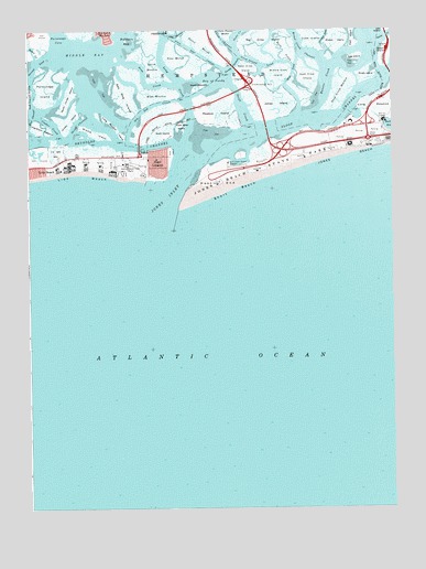
Jones Inlet, NY USGS Topographic Map
Click on map above to begin viewing in our Map Viewer.

This topographic map contains these locations and features:
Feature Name Type Latitude Longitude GNIS ID View Map
Alder IslandIslandN40.5984°W73.5787°942287View Map
Bay of FundyBayN40.6118°W73.5610°943181View Map
Bedell CreekStreamN40.6176°W73.6221°943483View Map
Big Crow IslandIslandN40.6226°W73.5429°943870View Map
Broad Creek ChannelChannelN40.6223°W73.5323°944782View Map
Bush CreekGutN40.6198°W73.5373°945307View Map
Cinder CreekChannelN40.6004°W73.6162°946701View Map
Cinder IslandIslandN40.6018°W73.6104°946702View Map
Coast Guard Station Jones Beach FreeportMilitaryN40.5906°W73.5567°2512114View Map
Crooked LeadChannelN40.6234°W73.5226°947785View Map
Crow Island LeadChannelN40.6159°W73.5446°947845View Map
Cuba IslandIslandN40.6237°W73.5282°947915View Map
Deep Creek MeadowFlatN40.6093°W73.5176°948168View Map
East Aler IslandIslandN40.6001°W73.5726°948964View Map
East Crow IslandIslandN40.6129°W73.5287°949055View Map
Egg IslandIslandN40.6182°W73.5121°949421View Map
False ChannelChannelN40.6234°W73.5596°970115View Map
Fundy ChannelChannelN40.6154°W73.5546°950808View Map
Goose CreekChannelN40.6237°W73.5015°951352View Map
Goose Creek BridgeBridgeN40.6235°W73.5015°2614912View Map
Great Sand CreekStreamN40.6176°W73.5537°971900View Map
Green IslandIslandN40.6193°W73.5012°951696View Map
Haunts CreekChannelN40.6118°W73.5226°952380View Map
Hempstead BayBayN40.6051°W73.5504°1802631View Map
Hempstead Town ParkParkN40.5893°W73.5896°952580View Map
High MeadowFlatN40.6082°W73.5812°952744View Map
Ingraham HassockIslandN40.5995°W73.6204°953724View Map
Interchange M 10CrossingN40.6109°W73.5493°974648View Map
Jones BayBayN40.5948°W73.5579°974288View Map
Jones BeachBeachN40.5945°W73.5029°954152View Map
Jones Beach State ParkParkN40.5976°W73.5148°954155View Map
Jones InletChannelN40.5826°W73.5779°954177View Map
Jones IslandIslandN40.6057°W73.5393°954178View Map
Lido and Point Lookout Fire District Action Engine Company 1BuildingN40.5923°W73.5800°2715936View Map
Lido and Point Lookout Fire District Ye Olde FirehouseBuildingN40.5923°W73.5796°2734830View Map
Lido BeachBeachN40.5868°W73.6168°955288View Map
Lido Beach Census Designated PlaceCensusN40.5846°W73.6078°2390063View Map
Lido Beach Wildlife Management AreaParkN40.5940°W73.6161°2765372View Map
Lido Boulevard ParkParkN40.5886°W73.6167°2075793View Map
Long CreekChannelN40.6134°W73.5754°955849View Map
Long Creek BridgeBridgeN40.6045°W73.5697°2614944View Map
Long MeadowFlatN40.6051°W73.5060°955883View Map
Long Meadow IslandIslandN40.5998°W73.5954°955884View Map
Marine TheaterBuildingN40.6015°W73.5029°956522View Map
Meadow IslandIslandN40.6040°W73.5601°956879View Map
Middle BayBayN40.6176°W73.6046°957075View Map
Middle Crow IslandIslandN40.6137°W73.5387°957095View Map
Middle IslandIslandN40.5984°W73.6018°957109View Map
Middle IslandIslandN40.6223°W73.5190°957110View Map
Nike Site NY-29/30L (historical)MilitaryN40.5931°W73.6150°2091900View Map
North ChannelChannelN40.6004°W73.6079°958741View Map
North Cinder IslandIslandN40.6076°W73.6110°958748View Map
North Meadow IslandIslandN40.6101°W73.5665°958854View Map
Our Lady of the Miraculous Medal Roman Catholic ChurchChurchN40.5911°W73.5833°2498341View Map
Parsonage IslandIslandN40.6095°W73.6187°959945View Map
Pettit MarshSwampN40.6232°W73.5671°960261View Map
Pine MarshSwampN40.6179°W73.5746°960507View Map
Point LookoutPopulated PlaceN40.5923°W73.5807°960827View Map
Point Lookout Census Designated PlaceCensusN40.5903°W73.5795°2389692View Map
Renegade Hook and Ladder Company 2BuildingN40.5937°W73.5839°2734831View Map
Scow CreekChannelN40.6118°W73.5849°964700View Map
Sea Dog CreekChannelN40.6051°W73.5832°964717View Map
Sea Dog IslandIslandN40.6079°W73.5912°964718View Map
Short BeachBeachN40.5834°W73.5546°965166View Map
Short Beach IslandIslandN40.5923°W73.5518°974290View Map
Sloop ChannelChannelN40.6057°W73.5146°974289View Map
Sloop Channel BridgeBridgeN40.5989°W73.5431°2614989View Map
Smith MeadowFlatN40.6157°W73.5821°965494View Map
Snipe IslandIslandN40.6132°W73.5087°965574View Map
Swift CreekChannelN40.6051°W73.5518°966931View Map
The Community ChurchChurchN40.5911°W73.5806°2498342View Map
West Crow IslandIslandN40.6148°W73.5498°969201View Map
West EndCapeN40.5851°W73.5604°969214View Map
Wife LeadChannelN40.6140°W73.5343°971226View Map
Zachs BayBayN40.6001°W73.5007°969311View Map

Note: Coordinates in the location and feature list above are referenced to NAD83 datum.


Copyright (C) 2008-2024 Ryan Niemi / Sunset Dynamics ... All Rights Reserved