TopoQuest Logo
Do you find TopoQuest useful?
Help keep TopoQuest running and adding new maps/features by donating!
Bitcoin:  19c7KJd3qBynnjoSw5npx9KScwjBe4ifkT
Litecoin:  LXs6TkuXGGXo1vDsWCkWVdjQX94eUKd6ui
Home View Maps Find Maps Find Places Resources & Links


Junction, Utah Topographic Map

USGS Map Title: Junction, UT
USGS Map MRC: 38112B2
DRG (GeoTIFF) Download: o38112b2.tif


Neighboring USGS Topographic Map Quads:


  Delano Peak, UT  
38112C3
 

  Piute Reservoir, UT  
38112C2
 

  Malmsten Peak, UT  
38112C1
 

  Circleville, UT  
38112B3
 

  Junction, UT  
38112B2
 

  Phonolite Hill, UT  
38112B1
 

  Bull Rush Peak, UT  
38112A3
 

  Mount Dutton, UT  
38112A2
 

  Deep Creek, UT  
38112A1


Map MRC Location:

N39°
W113°
N39°
W112°
H8 H7 H6 H5 H4 H3 H2 H1
G8 G7 G6 G5 G4 G3 G2 G1
F8 F7 F6 F5 F4 F3 F2 F1
E8 E7 E6 E5 E4 E3 E2 E1
D8 D7 D6 D5 D4 D3 D2 D1
C8 C7 C6 C5 C4 C3 C2 C1
B8 B7 B6 B5 B4 B3 B2 B1
A8 A7 A6 A5 A4 A3 A2 A1
N38°
W113°
N38°
W112°

Junction, UT USGS 1:24K Topographic Map Preview:
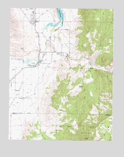
Junction, UT USGS Topographic Map
Click on map above to begin viewing in our Map Viewer.

This topographic map contains these locations and features:
Feature Name Type Latitude Longitude GNIS ID View Map
Burnt HollowValleyN38.1369°W112.2121°1439358View Map
Circle ValleyValleyN38.1950°W112.2196°1439748View Map
Coates HollowValleyN38.1930°W112.1344°1439851View Map
East Fork Sevier RiverStreamN38.2303°W112.1924°1440820View Map
Jones Corral DrawValleyN38.1280°W112.1541°1442207View Map
JunctionPopulated PlaceN38.2375°W112.2199°1442250View Map
Junction CemeteryCemeteryN38.2229°W112.2167°1448528View Map
Junction Fire DepartmentBuildingN38.2390°W112.2240°2627452View Map
Junction Hill CemeteryCemeteryN38.2375°W112.2202°1449892View Map
Junction Lower CemeteryCemeteryN38.2375°W112.2202°1449893View Map
Junction Post OfficePost OfficeN38.2445°W112.2208°1455347View Map
KingstonPopulated PlaceN38.2083°W112.1877°1442334View Map
Kingston CanyonValleyN38.2050°W112.1796°1442336View Map
Kingston CemeteryCemeteryN38.2002°W112.1944°1448549View Map
Piute County AmbulanceBuildingN38.2447°W112.2208°2665415View Map
Piute County Sheriff's OfficeBuildingN38.2448°W112.2208°2730370View Map
Piute High SchoolSchoolN38.2455°W112.2219°1444468View Map
Piute ReservoirReservoirN38.2351°W112.2014°1444469View Map
Rocky Ford CreekStreamN38.2003°W112.1538°1445116View Map
Rocky Ford ReservoirReservoirN38.1763°W112.1610°1445118View Map
Rocky Ford TrailTrailN38.1394°W112.1744°1445119View Map
Smiths ReservoirReservoirN38.1538°W112.1895°1445715View Map
Table MountainSummitN38.1411°W112.1405°1446318View Map
Terrace Hill CemeteryCemeteryN38.2375°W112.2202°1449898View Map
Town of JunctionCivilN38.2358°W112.2238°2412813View Map
Town of KingstonCivilN38.2066°W112.1792°2412836View Map
West CanalCanalN38.2419°W112.2141°1447116View Map

Note: Coordinates in the location and feature list above are referenced to NAD83 datum.


Copyright (C) 2008-2024 Ryan Niemi / Sunset Dynamics ... All Rights Reserved