TopoQuest Logo
Do you find TopoQuest useful?
Help keep TopoQuest running and adding new maps/features by donating!
Bitcoin:  19c7KJd3qBynnjoSw5npx9KScwjBe4ifkT
Litecoin:  LXs6TkuXGGXo1vDsWCkWVdjQX94eUKd6ui
Home View Maps Find Maps Find Places Resources & Links


Kendallville, Indiana Topographic Map

USGS Map Title: Kendallville, IN
USGS Map MRC: 41085D3
DRG (GeoTIFF) Download: o41085d3.tif


Neighboring USGS Topographic Map Quads:


  Oliver Lake, IN  
41085E4
 

  Wolcottville, IN  
41085E3
 

  Stroh, IN  
41085E2
 

  Albion, IN  
41085D4
 

  Kendallville, IN  
41085D3
 

  Corunna, IN  
41085D2
 

  Merriam, IN  
41085C4
 

  Ege, IN  
41085C3
 

  Garrett, IN  
41085C2


Map MRC Location:

N42°
W86°
N42°
W85°
H8 H7 H6 H5 H4 H3 H2 H1
G8 G7 G6 G5 G4 G3 G2 G1
F8 F7 F6 F5 F4 F3 F2 F1
E8 E7 E6 E5 E4 E3 E2 E1
D8 D7 D6 D5 D4 D3 D2 D1
C8 C7 C6 C5 C4 C3 C2 C1
B8 B7 B6 B5 B4 B3 B2 B1
A8 A7 A6 A5 A4 A3 A2 A1
N41°
W86°
N41°
W85°

Kendallville, IN USGS 1:24K Topographic Map Preview:
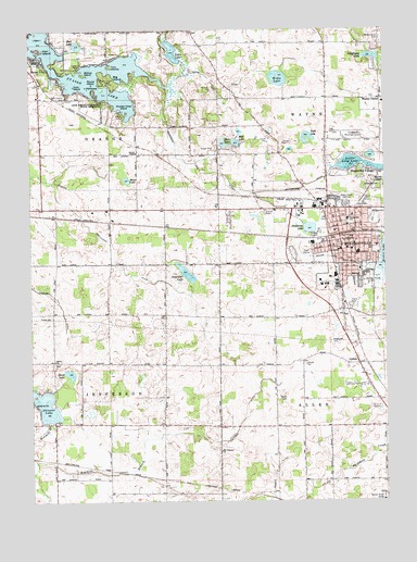
Kendallville, IN USGS Topographic Map
Click on map above to begin viewing in our Map Viewer.

This topographic map contains these locations and features:
Feature Name Type Latitude Longitude GNIS ID View Map
Barr LakeLakeN41.4960°W85.3578°430522View Map
Beck LakeLakeN41.4702°W85.3023°430690View Map
Big IslandIslandN41.4878°W85.3478°431040View Map
Bishop IslandIslandN41.4884°W85.3555°431107View Map
Bixler Lake DitchCanalN41.4389°W85.2650°431114View Map
Boughey DitchCanalN41.4287°W85.3655°431376View Map
Center ChapelChurchN41.4675°W85.3372°432318View Map
Central Elementary SchoolSchoolN41.4403°W85.2594°447300View Map
Chicken Coop IslandIslandN41.4792°W85.3414°432471View Map
City of KendallvilleCivilN41.4441°W85.2578°2395505View Map
Cook IslandIslandN41.4853°W85.3594°432918View Map
Crothers DitchCanalN41.3973°W85.2997°433194View Map
Duck LakeLakeN41.4719°W85.2766°433748View Map
East Noble High SchoolSchoolN41.4353°W85.2569°447306View Map
Elmwood ChurchChurchN41.4339°W85.2589°434137View Map
Gem IslandIslandN41.4981°W85.3728°435011View Map
Gene Stratton Porter State MemorialParkN41.4806°W85.3491°435012View Map
Gretzinger DitchCanalN41.4375°W85.3455°435487View Map
Hall LakeLakeN41.4701°W85.3067°435616View Map
Hathaway IslandIslandN41.4853°W85.3547°435878View Map
Henderson LakeLakeN41.4473°W85.2765°436013View Map
Henderson Lake DitchCanalN41.4656°W85.3203°436014View Map
KendallvillePopulated PlaceN41.4414°W85.2650°437239View Map
Kendallville Fire Department Station 1BuildingN41.4374°W85.2691°2626320View Map
Kendallville Fire Department Station 2 HeadquartersBuildingN41.4520°W85.2631°2625819View Map
Kendallville Middle SchoolSchoolN41.4403°W85.2594°447310View Map
Kendallville Municipal AirportAirportN41.4713°W85.2650°449223View Map
Kendallville Police DepartmentBuildingN41.4415°W85.2656°2758269View Map
Kerr IslandIslandN41.4948°W85.3716°437266View Map
Lake View CemeteryCemeteryN41.4579°W85.2542°437561View Map
Latta LakeLakeN41.4942°W85.3245°437642View Map
LisbonPopulated PlaceN41.4112°W85.2597°437978View Map
Little Long LakeLakeN41.4641°W85.2599°438091View Map
Mount Pleasant ChurchChurchN41.3884°W85.3086°439688View Map
Munk LakeLakeN41.4601°W85.3407°439883View Map
North Side Elementary SchoolSchoolN41.4498°W85.2628°440297View Map
Old Kendallville CemeteryCemeteryN41.4498°W85.2700°440548View Map
Oviatt DitchCanalN41.4812°W85.3069°440787View Map
Parkview Noble HospitalHospitalN41.4483°W85.2962°2660452View Map
Perseverance CemeteryCemeteryN41.4978°W85.2511°441037View Map
Rimmell BranchStreamN41.3959°W85.3694°442043View Map
Round IslandIslandN41.4859°W85.3528°442347View Map
Sacarider LakeLakeN41.4355°W85.3202°442439View Map
Schockopee LakeLakeN41.4926°W85.2539°443086View Map
Skinner LakeLakeN41.4007°W85.3704°443584View Map
Sweet ChurchChurchN41.4123°W85.3666°444480View Map
Sweet LakeLakeN41.4089°W85.3614°444482View Map
Sylvan LakeLakeN41.4887°W85.3529°444518View Map
Town of Rome CityCivilN41.4892°W85.3610°2396888View Map
Township of AllenCivilN41.3944°W85.2509°453086View Map
Township of JeffersonCivilN41.3950°W85.3636°453493View Map
Township of OrangeCivilN41.4821°W85.3657°453690View Map
Township of WayneCivilN41.4820°W85.2510°454037View Map
Twin IslandIslandN41.4906°W85.3464°445013View Map
Varner Sand and Gravel PitMineN41.4700°W85.2906°2649816View Map
Wakeville VillagePopulated PlaceN41.4631°W85.2569°445363View Map
Waterhouse DitchCanalN41.4592°W85.2778°445539View Map
WAWF-FM (Kendallville)TowerN41.4553°W85.2622°449034View Map
WAWK-AM (Kendallville)TowerN41.4545°W85.2633°448413View Map
Wayne CenterPopulated PlaceN41.4817°W85.2508°445579View Map
Wayne Center Elementary SchoolSchoolN41.4809°W85.2505°447301View Map
Wible LakeLakeN41.4870°W85.2871°446001View Map

Note: Coordinates in the location and feature list above are referenced to NAD83 datum.


Copyright (C) 2008-2024 Ryan Niemi / Sunset Dynamics ... All Rights Reserved