TopoQuest Logo
Do you find TopoQuest useful?
Help keep TopoQuest running and adding new maps/features by donating!
Bitcoin:  19c7KJd3qBynnjoSw5npx9KScwjBe4ifkT
Litecoin:  LXs6TkuXGGXo1vDsWCkWVdjQX94eUKd6ui
Home View Maps Find Maps Find Places Resources & Links


Kildare, Georgia Topographic Map

USGS Map Title: Kildare, GA
USGS Map MRC: 32081E4
DRG (GeoTIFF) Download: o32081e4.tif


Neighboring USGS Topographic Map Quads:


  Hunters, GA  
32081F5
 

  Blue Springs Landing, GA  
32081F4
 

  Shirley, SC  
32081F3
 

  Oliver, GA  
32081E5
 

  Kildare, GA  
32081E4
 

  Brighton, SC  
32081E3
 

  Leefield, GA  
32081D5
 

  Egypt, GA  
32081D4
 

  Springfield North, GA  
32081D3


Map MRC Location:

N33°
W82°
N33°
W81°
H8 H7 H6 H5 H4 H3 H2 H1
G8 G7 G6 G5 G4 G3 G2 G1
F8 F7 F6 F5 F4 F3 F2 F1
E8 E7 E6 E5 E4 E3 E2 E1
D8 D7 D6 D5 D4 D3 D2 D1
C8 C7 C6 C5 C4 C3 C2 C1
B8 B7 B6 B5 B4 B3 B2 B1
A8 A7 A6 A5 A4 A3 A2 A1
N32°
W82°
N32°
W81°

Kildare, GA USGS 1:24K Topographic Map Preview:
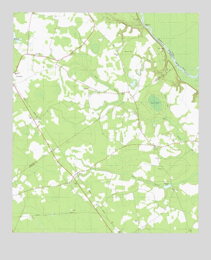
Kildare, GA USGS Topographic Map
Click on map above to begin viewing in our Map Viewer.

This topographic map contains these locations and features:
Feature Name Type Latitude Longitude GNIS ID View Map
Bethel ChurchChurchN32.5424°W81.4015°311177View Map
Colson School (historical)SchoolN32.6227°W81.4882°350163View Map
Coursey CemeteryCemeteryN32.5621°W81.4095°350211View Map
Coursey School (historical)SchoolN32.5821°W81.4493°350164View Map
Dugger CemeteryCemeteryN32.5474°W81.4032°350213View Map
Effingham County Fire Rescue Station 7BuildingN32.5522°W81.3797°2603740View Map
Eneck (historical)Populated PlaceN32.6010°W81.4026°350166View Map
Eneck BaySwampN32.6044°W81.4217°313947View Map
Eneck CemeteryCemeteryN32.6013°W81.4282°313948View Map
Eneck LandingLocaleN32.6046°W81.3979°331664View Map
Ferry BranchStreamN32.6182°W81.4121°314109View Map
Friendship TabernacleChurchN32.5818°W81.4487°314439View Map
Green BaySwampN32.5749°W81.3965°314815View Map
Hudson Ferry (historical)CrossingN32.6180°W81.4118°350174View Map
Hudson Ferry (historical)CrossingN32.6180°W81.4118°1232171View Map
Hudson Ferry LandingLocaleN32.6185°W81.4121°332040View Map
Hudson Ferry ReachChannelN32.5988°W81.3912°315788View Map
Hudson Ferry ReachChannelN32.6052°W81.3968°1223371View Map
KildarePopulated PlaceN32.5343°W81.4554°332146View Map
Mariah Grove School (historical)SchoolN32.5121°W81.4429°350238View Map
Mizpah ChurchChurchN32.5488°W81.4026°318358View Map
Mizpah School (historical)SchoolN32.5641°W81.4023°350246View Map
Nixon ChapelChurchN32.5071°W81.4154°319603View Map
North Newington ChurchChurchN32.6010°W81.4854°319658View Map
Oakgrove ChurchChurchN32.5368°W81.3984°319858View Map
OakyPopulated PlaceN32.5249°W81.3909°326433View Map
Rooty BranchStreamN32.5988°W81.3909°321893View Map
Saint Peters ChurchChurchN32.6013°W81.4612°322298View Map
Saint Peters School (historical)SchoolN32.6016°W81.4609°350190View Map
Sand PondLakeN32.5743°W81.4040°322435View Map
Southside SchoolSchoolN32.5902°W81.4976°323306View Map
Tiger Leap BluffCliffN32.6246°W81.4162°324173View Map
Walker Grove School (historical)SchoolN32.5868°W81.4987°350201View Map
Wallace TempleChurchN32.5052°W81.4096°350277View Map
Wilsons PondLakeN32.5267°W81.3955°325438View Map

Note: Coordinates in the location and feature list above are referenced to NAD83 datum.


Copyright (C) 2008-2025 Ryan Niemi / Sunset Dynamics ... All Rights Reserved