TopoQuest Logo
Do you find TopoQuest useful?
Help keep TopoQuest running and adding new maps/features by donating!
Bitcoin:  19c7KJd3qBynnjoSw5npx9KScwjBe4ifkT
Litecoin:  LXs6TkuXGGXo1vDsWCkWVdjQX94eUKd6ui
Home View Maps Find Maps Find Places Resources & Links


Killenbeck Reservoir, Montana Topographic Map

USGS Map Title: Killenbeck Reservoir, MT
USGS Map MRC: 48105G6
DRG (GeoTIFF) Download: o48105g6.tif


Neighboring USGS Topographic Map Quads:


  Carbert, MT  
48105H7
 

  Four Buttes NW, MT  
48105H6
 

  Four Buttes NE, MT  
48105H5
 

  Peerless, MT  
48105G7
 

  Killenbeck Reservoir, MT  
48105G6
 

  Four Buttes, MT  
48105G5
 

  West Fork NE, MT  
48105F7
 

  Shipstead Coulee, MT  
48105F6
 

  South of Four Buttes, MT  
48105F5


Map MRC Location:

N49°
W106°
N49°
W105°
H8 H7 H6 H5 H4 H3 H2 H1
G8 G7 G6 G5 G4 G3 G2 G1
F8 F7 F6 F5 F4 F3 F2 F1
E8 E7 E6 E5 E4 E3 E2 E1
D8 D7 D6 D5 D4 D3 D2 D1
C8 C7 C6 C5 C4 C3 C2 C1
B8 B7 B6 B5 B4 B3 B2 B1
A8 A7 A6 A5 A4 A3 A2 A1
N48°
W106°
N48°
W105°

Killenbeck Reservoir, MT USGS 1:24K Topographic Map Preview:
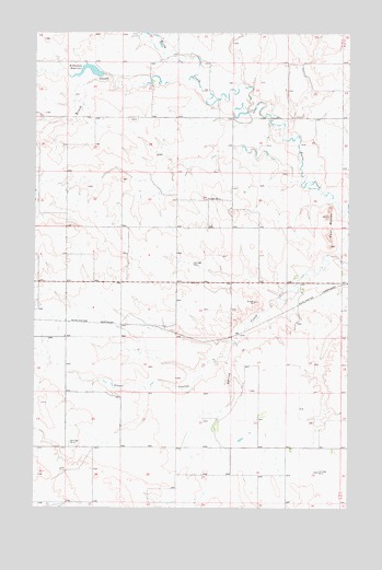
Killenbeck Reservoir, MT USGS Topographic Map
Click on map above to begin viewing in our Map Viewer.

This topographic map contains these locations and features:
Feature Name Type Latitude Longitude GNIS ID View Map
35N46E01CCDA01 WellWellN48.8106°W105.6456°1636661View Map
35N46E01CCDA02 WellWellN48.8109°W105.6461°1636663View Map
35N46E04CBCD01 WellWellN48.8134°W105.7111°1636672View Map
35N46E04CBDB01 WellWellN48.8145°W105.7128°1636679View Map
35N46E09DCAA01 WellWellN48.7978°W105.7006°1636587View Map
35N46E10DDDD01 WellWellN48.7959°W105.6731°1636580View Map
35N46E11AADC01 WellWellN48.8059°W105.6522°1636635View Map
35N46E11AADC02 WellWellN48.8020°W105.6617°1636613View Map
35N46E12BACB01 WellWellN48.7978°W105.6439°1636586View Map
35N46E12BACB02 WellWellN48.7989°W105.6442°1636596View Map
35N46E17ABCA01 WellWellN48.7922°W105.7242°1636559View Map
35N46E20AAAB01 WellWellN48.7797°W105.7172°1636502View Map
35N46E20AAAB02 WellWellN48.7797°W105.7178°1636503View Map
35N46E20CCCD01 WellWellN48.7747°W105.7350°1636483View Map
35N46E22CBDD01 WellWellN48.7700°W105.6894°1636450View Map
35N46E22CBDD02 WellWellN48.7697°W105.6894°1636449View Map
35N46E22DBDA01 WellWellN48.7709°W105.6783°1636457View Map
35N46E23ACCA01 WellWellN48.7745°W105.6583°1636481View Map
35N46E23ACCC01 WellWellN48.7742°W105.6597°1636472View Map
35N46E24DBCA01 WellWellN48.7709°W105.6367°1636456View Map
35N46E25AAAC01 WellWellN48.7647°W105.6306°1636423View Map
35N46E25BBBA01 WellWellN48.7653°W105.6478°1636426View Map
35N46E26CDAC01 WellWellN48.7542°W105.6631°1636379View Map
35N46E30ADDB01 WellWellN48.7600°W105.7400°1636402View Map
35N47E06CCBC01 WellWellN48.8120°W105.6275°1636668View Map
36N46E15CDDD01 WellWellN48.8675°W105.6833°1636869View Map
36N46E20ABDD01 WellWellN48.8642°W105.7220°1636857View Map
36N46E21ACCB01 WellWellN48.8617°W105.7042°1636848View Map
36N46E23AAAA01 WellWellN48.8667°W105.6506°1636866View Map
36N46E31BAAA01 WellWellN48.8381°W105.7497°1636776View Map
36N46E33ABBB01 WellWellN48.8378°W105.7047°1636772View Map
36N46E35DCCC01 WellWellN48.8247°W105.6603°1636726View Map
Brush CreekStreamN48.8639°W105.6889°769308View Map
Four ButtesSummitN48.8270°W105.6339°1637570View Map
Gluten (historical)LocaleN48.7984°W105.7275°1637396View Map
Killenbeck Lake DamDamN48.8641°W105.7237°795195View Map
Killenbeck ReservoirReservoirN48.8661°W105.7306°773032View Map
Olson CouleeValleyN48.7934°W105.6736°774962View Map

Note: Coordinates in the location and feature list above are referenced to NAD83 datum.


Copyright (C) 2008-2025 Ryan Niemi / Sunset Dynamics ... All Rights Reserved