TopoQuest Logo
Do you find TopoQuest useful?
Help keep TopoQuest running and adding new maps/features by donating!
Bitcoin:  19c7KJd3qBynnjoSw5npx9KScwjBe4ifkT
Litecoin:  LXs6TkuXGGXo1vDsWCkWVdjQX94eUKd6ui
Home View Maps Find Maps Find Places Resources & Links


Kimball, Nebraska Topographic Map

USGS Map Title: Kimball, NE
USGS Map MRC: 41103B6
DRG (GeoTIFF) Download: o41103b6.tif


Neighboring USGS Topographic Map Quads:


  North of Oliver Reservoir, NE  
41103C7
 

  Bennett Reservoir West, NE  
41103C6
 

  Bennett Reservoir East, NE  
41103C5
 

  Oliver Reservoir, NE  
41103B7
 

  Kimball, NE  
41103B6
 

  Owasco, NE  
41103B5
 

  Bushnell SE, NE  
41103A7
 

  Kimball SW, NE  
41103A6
 

  Kimball SE, NE  
41103A5


Map MRC Location:

N42°
W104°
N42°
W103°
H8 H7 H6 H5 H4 H3 H2 H1
G8 G7 G6 G5 G4 G3 G2 G1
F8 F7 F6 F5 F4 F3 F2 F1
E8 E7 E6 E5 E4 E3 E2 E1
D8 D7 D6 D5 D4 D3 D2 D1
C8 C7 C6 C5 C4 C3 C2 C1
B8 B7 B6 B5 B4 B3 B2 B1
A8 A7 A6 A5 A4 A3 A2 A1
N41°
W104°
N41°
W103°

Kimball, NE USGS 1:24K Topographic Map Preview:
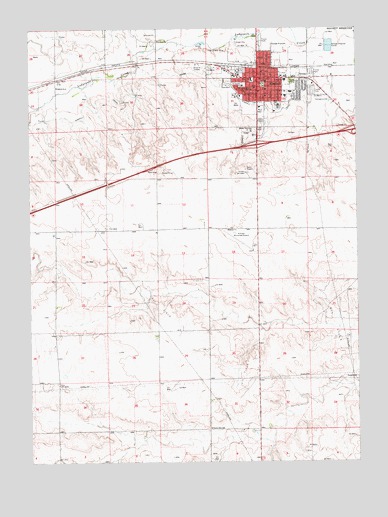
Kimball, NE USGS Topographic Map
Click on map above to begin viewing in our Map Viewer.

This topographic map contains these locations and features:
Feature Name Type Latitude Longitude GNIS ID View Map
Antelope Election PrecinctCivilN41.1972°W103.6786°1928694View Map
Cederburg DamDamN41.1683°W103.7072°1770184View Map
Cederburg ReservoirReservoirN41.1683°W103.7072°1770185View Map
Church of ChristChurchN41.2319°W103.6486°1830165View Map
City of KimballCivilN41.2335°W103.6513°2395530View Map
Family ClinicHospitalN41.2375°W103.6622°1830187View Map
First Baptist ChurchChurchN41.2316°W103.6544°1830166View Map
First English Lutheran ChurchChurchN41.2330°W103.6641°1830167View Map
First United Presbyterian ChurchChurchN41.2305°W103.6697°1830171View Map
Gotte ParkParkN41.2353°W103.6494°829598View Map
High Plains Cooperative ElevatorLocaleN41.2358°W103.6630°1830189View Map
Interchange 20CrossingN41.2166°W103.6630°1830215View Map
Interchange 22CrossingN41.2205°W103.6261°1830216View Map
Janicek DamDamN41.2250°W103.6555°1768205View Map
Janicek ReservoirReservoirN41.2250°W103.6555°1768206View Map
KimballLocaleN41.2389°W103.6669°1830177View Map
KimballPopulated PlaceN41.2358°W103.6630°830504View Map
Kimball Assembly of God ChurchChurchN41.2361°W103.6577°1830168View Map
Kimball CanalCanalN41.2350°W103.7052°830505View Map
Kimball City ParkParkN41.2339°W103.6608°1830199View Map
Kimball City Police DepartmentBuildingN41.2368°W103.6626°1830186View Map
Kimball CountyCivilN41.1977°W103.7149°835874View Map
Kimball County Ambulance ServiceBuildingN41.2354°W103.6610°2553782View Map
Kimball County CourthouseBuildingN41.2353°W103.6619°1830183View Map
Kimball County Hospital ClinicHospitalN41.2325°W103.6669°1830195View Map
Kimball County ManorHospitalN41.2305°W103.6524°1830193View Map
Kimball County Sheriff OfficeBuildingN41.2356°W103.6624°1830184View Map
Kimball Evangelical Free ChurchChurchN41.2383°W103.6599°1830175View Map
Kimball Health ServicesHospitalN41.2326°W103.6668°1830194View Map
Kimball High SchoolSchoolN41.2272°W103.6552°1830181View Map
Kimball Junior High SchoolSchoolN41.2353°W103.6524°1830180View Map
Kimball KOA CampgroundLocaleN41.2358°W103.6630°1830190View Map
Kimball Municipal Airport/Robert E Arraj FieldAirportN41.1881°W103.6774°837612View Map
Kimball Number 1 Election PrecinctCivilN41.2313°W103.6663°1928991View Map
Kimball Number 2 Election PrecinctCivilN41.2335°W103.6468°1928992View Map
Kimball Post OfficePost OfficeN41.2373°W103.6646°1830178View Map
Kimball Public LibraryBuildingN41.2369°W103.6619°1830188View Map
Kimball Southern Baptist ChurchChurchN41.2322°W103.6599°1830169View Map
Kimball Vision ClinicHospitalN41.2383°W103.6636°1830182View Map
Kimball Volunteer Fire DepartmentBuildingN41.2369°W103.6648°1830185View Map
Kimball-Banner Counties FairgroundsLocaleN41.2328°W103.6519°1830198View Map
Kingdom Hall of Jehovah WitnessesChurchN41.2358°W103.6630°1830176View Map
Mary Lynch Elementary SchoolSchoolN41.2316°W103.6505°1830179View Map
Plains Historical MuseumBuildingN41.2369°W103.6633°1830196View Map
Prairie Dale SchoolSchoolN41.1347°W103.6816°832353View Map
Ridgewood Mobile Home ParkPopulated PlaceN41.2328°W103.6422°1830191View Map
Saint Hildas Episcopal ChurchChurchN41.2319°W103.6624°1830172View Map
Saint Joesphs SchoolSchoolN41.2339°W103.6686°832878View Map
Saint Johns Lutheran ChurchChurchN41.2319°W103.6680°1830173View Map
Saint Josephs Catholic ChurchChurchN41.2322°W103.6655°1830174View Map
School Number 5SchoolN41.2333°W103.7399°836808View Map
Stahlas North CourtPopulated PlaceN41.2378°W103.6699°1830192View Map
Trinity United Methodist ChurchChurchN41.2347°W103.6597°1830170View Map
Twin Pines CampgroundLocaleN41.2358°W103.6630°1830197View Map
West SchoolSchoolN41.2350°W103.6649°834616View Map
Yung North DamDamN41.2116°W103.7022°1769004View Map
Yung North ReservoirReservoirN41.2116°W103.7022°1769005View Map
Yung South DamDamN41.1333°W103.6888°1769006View Map
Yung South ReservoirReservoirN41.1333°W103.6888°1769007View Map

Note: Coordinates in the location and feature list above are referenced to NAD83 datum.


Copyright (C) 2008-2025 Ryan Niemi / Sunset Dynamics ... All Rights Reserved