TopoQuest Logo
Do you find TopoQuest useful?
Help keep TopoQuest running and adding new maps/features by donating!
Bitcoin:  19c7KJd3qBynnjoSw5npx9KScwjBe4ifkT
Litecoin:  LXs6TkuXGGXo1vDsWCkWVdjQX94eUKd6ui
Home View Maps Find Maps Find Places Resources & Links


Kinderhook, Michigan Topographic Map

USGS Map Title: Kinderhook, MI
USGS Map MRC: 41085G1
DRG (GeoTIFF) Download: o41085g1.tif


Neighboring USGS Topographic Map Quads:


  Bronson North, MI  
41085H2
 

  Coldwater West, MI  
41085H1
 

  Coldwater East, MI  
41084H8
 

  Bronson South, MI  
41085G2
 

  Kinderhook, MI  
41085G1
 

  California, MI  
41084G8
 

  Orland, IN  
41085F2
 

  Angola West, IN  
41085F1
 

  Angola East, IN  
41084F8


Map MRC Location:

N42°
W86°
N42°
W85°
H8 H7 H6 H5 H4 H3 H2 H1
G8 G7 G6 G5 G4 G3 G2 G1
F8 F7 F6 F5 F4 F3 F2 F1
E8 E7 E6 E5 E4 E3 E2 E1
D8 D7 D6 D5 D4 D3 D2 D1
C8 C7 C6 C5 C4 C3 C2 C1
B8 B7 B6 B5 B4 B3 B2 B1
A8 A7 A6 A5 A4 A3 A2 A1
N41°
W86°
N41°
W85°

Kinderhook, MI USGS 1:24K Topographic Map Preview:
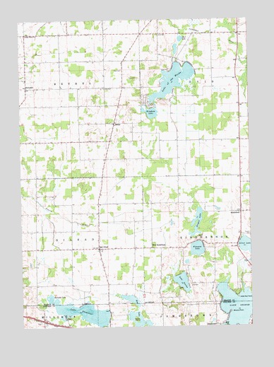
Kinderhook, MI USGS Topographic Map
Click on map above to begin viewing in our Map Viewer.

This topographic map contains these locations and features:
Feature Name Type Latitude Longitude GNIS ID View Map
Ammerman CemeteryCemeteryN41.8583°W85.0689°2435435View Map
Barton LakeLakeN41.7500°W85.0623°430550View Map
BethelPopulated PlaceN41.8328°W85.0736°1625051View Map
Bethel Gilead Community ChurchChurchN41.7856°W85.0831°2435355View Map
Bethel Post Office (historical)Post OfficeN41.8328°W85.0736°1625558View Map
Bingham LakeLakeN41.8372°W85.0534°621388View Map
Brown IslandIslandN41.7531°W85.0627°431625View Map
Browns PointCapeN41.7562°W85.0114°431642View Map
Byers LakeLakeN41.8672°W85.0366°632892View Map
Card CemeteryCemeteryN41.8545°W85.0694°622708View Map
Chester LakeLakeN41.7764°W85.0350°1617056View Map
Dragon LakeLakeN41.7894°W85.0300°624870View Map
East GileadPopulated PlaceN41.7820°W85.0830°625186View Map
East Gilead CemeteryCemeteryN41.7858°W85.0825°2435444View Map
East Gilead Missionary ChurchChurchN41.7819°W85.0831°2435354View Map
East Gilead Post Office (historical)Post OfficeN41.7819°W85.0831°2435394View Map
Green Acres CampgroundLocaleN41.8489°W85.0478°2435296View Map
HatmakerPopulated PlaceN41.8475°W85.1214°1617611View Map
Hatmaker Post Office (historical)Post OfficeN41.8475°W85.1214°2435397View Map
Hog LakeLakeN41.7556°W85.0619°436289View Map
KinderhookPopulated PlaceN41.7967°W85.0052°629686View Map
Kinderhook Post Office (historical)Post OfficeN41.7967°W85.0053°2435392View Map
Kope Kon PointCapeN41.7620°W85.0072°629855View Map
Lake GeorgeReservoirN41.7582°W85.0081°452441View Map
Lake George DamDamN41.7510°W85.0142°448709View Map
Lake LavineLakeN41.7683°W85.0377°630201View Map
Lake MichianaLakeN41.7612°W85.0649°449515View Map
Lake of the WoodsLakeN41.8504°W85.0408°1616801View Map
Lake PleasantReservoirN41.7558°W85.0909°441354View Map
Lakeland Fire DepartmentBuildingN41.8092°W85.0057°2636241View Map
Little Fawn RiverStreamN41.7667°W85.0052°449509View Map
Little Rose LakeLakeN41.8631°W85.0393°1617052View Map
Long Beach LakeLakeN41.7505°W85.0226°451875View Map
North Pleasant LakeLakeN41.7817°W85.0293°635096View Map
Ovid CemeteryCemeteryN41.8689°W85.0489°634235View Map
Ovid Post Office (historical)Post OfficeN41.8689°W85.0489°2435366View Map
Red Water LakeLakeN41.7614°W85.1087°635747View Map
School Number 6SchoolN41.8473°W85.0789°637405View Map
Snow Prairie SchoolSchoolN41.8692°W85.1214°638208View Map
Sorter CemeteryCemeteryN41.8272°W85.0053°2435443View Map
Township of BethelCivilN41.8545°W85.1170°1625931View Map
Township of GileadCivilN41.7854°W85.1166°1626351View Map
Township of KinderhookCivilN41.7854°W85.0003°1626560View Map
Township of OvidCivilN41.8547°W85.0002°1626873View Map
Vohs LakeLakeN41.7606°W85.0894°1617014View Map
West KinderhookPopulated PlaceN41.7820°W85.0541°1617929View Map

Note: Coordinates in the location and feature list above are referenced to NAD83 datum.


Copyright (C) 2008-2024 Ryan Niemi / Sunset Dynamics ... All Rights Reserved