TopoQuest Logo
Do you find TopoQuest useful?
Help keep TopoQuest running and adding new maps/features by donating!
Bitcoin:  19c7KJd3qBynnjoSw5npx9KScwjBe4ifkT
Litecoin:  LXs6TkuXGGXo1vDsWCkWVdjQX94eUKd6ui
Home View Maps Find Maps Find Places Resources & Links


Kings, Illinois Topographic Map

USGS Map Title: Kings, IL
USGS Map MRC: 42089A1
DRG (GeoTIFF) Download: o42089a1.tif


Neighboring USGS Topographic Map Quads:


  Kishwaukee, IL  
42089B2
 

  Rockford South, IL  
42089B1
 

  Cherry Valley, IL  
42088B8
 

  Stillman Valley, IL  
42089A2
 

  Kings, IL  
42089A1
 

  Fairdale, IL  
42088A8
 

  Chana, IL  
41089H2
 

  Rochelle, IL  
41089H1
 

  Creston, IL  
41088H8


Map MRC Location:

N43°
W90°
N43°
W89°
H8 H7 H6 H5 H4 H3 H2 H1
G8 G7 G6 G5 G4 G3 G2 G1
F8 F7 F6 F5 F4 F3 F2 F1
E8 E7 E6 E5 E4 E3 E2 E1
D8 D7 D6 D5 D4 D3 D2 D1
C8 C7 C6 C5 C4 C3 C2 C1
B8 B7 B6 B5 B4 B3 B2 B1
A8 A7 A6 A5 A4 A3 A2 A1
N42°
W90°
N42°
W89°

Kings, IL USGS 1:24K Topographic Map Preview:
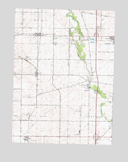
Kings, IL USGS Topographic Map
Click on map above to begin viewing in our Map Viewer.

This topographic map contains these locations and features:
Feature Name Type Latitude Longitude GNIS ID View Map
Alcock RLA Airport (historical)AirportN42.0696°W89.0365°427462View Map
Bauer Airport (historical)AirportN42.0585°W89.0212°2679060View Map
Beacon School (historical)SchoolN42.0789°W89.0754°1706035View Map
Bethel CemeteryCemeteryN42.0070°W89.0851°1808185View Map
Big Mound CemeteryCemeteryN42.0795°W89.1095°404421View Map
Davis JunctionPopulated PlaceN42.1017°W89.0932°406979View Map
Davis Junction Post OfficePost OfficeN42.1011°W89.1004°2788770View Map
Eudy Airport (historical)AirportN42.0936°W89.0298°2679065View Map
HolcombPopulated PlaceN42.0647°W89.0957°410374View Map
Holcomb Post OfficePost OfficeN42.0647°W89.0961°1808241View Map
Interchange 104CrossingN42.0070°W89.0209°1808244View Map
Interchange 111CrossingN42.1031°W89.0232°1808245View Map
Kilbuck CemeteryCemeteryN42.1228°W89.0426°411465View Map
Killbuck School (historical)SchoolN42.1225°W89.0426°1706037View Map
KingsPopulated PlaceN42.0042°W89.1059°411506View Map
Kings Elementary SchoolSchoolN42.0017°W89.1054°1808247View Map
LindenwoodPopulated PlaceN42.0531°W89.0307°412230View Map
Lindenwood CemeteryCemeteryN42.0503°W89.0356°412231View Map
Lindenwood Post OfficePost OfficeN42.0527°W89.0306°1808253View Map
Lindenwood SchoolSchoolN42.0561°W89.0326°1808254View Map
Luda School (historical)SchoolN42.0217°W89.0654°1706032View Map
Lynn Scott Rock Fire Protection District Davis Junction StationBuildingN42.1008°W89.0960°2640912View Map
Lynn Scott Rock Fire Protection District Linwood StationBuildingN42.0528°W89.0316°2640391View Map
Maple Hurst Farms AirportAirportN42.0084°W89.0440°427741View Map
Maplehurst Stock FarmLocaleN42.0100°W89.0414°2680777View Map
Monroe CenterPopulated PlaceN42.0984°W89.0007°413728View Map
Monroe Center CemeteryCemeteryN42.1003°W89.0045°1808259View Map
Monroe Center Grade SchoolSchoolN42.1000°W89.0062°1808260View Map
Monroe Center Post OfficePost OfficeN42.0983°W89.0007°2788181View Map
Monroe Township Fire Protection DistrictBuildingN42.1004°W89.0029°2640667View Map
Moore School (historical)SchoolN42.0211°W89.0307°1706031View Map
Phelps School (historical)SchoolN42.0509°W89.0704°1706034View Map
Somers Blossom AirportAirportN42.0601°W89.0006°427463View Map
Spring RunStreamN42.0403°W89.0065°422102View Map
Township of ScottCivilN42.1071°W89.1145°429724View Map
Township of White RockCivilN42.0203°W89.1140°429931View Map
Village of Davis JunctionCivilN42.1143°W89.0898°2398688View Map
Warren School (historical)SchoolN42.0778°W89.0290°1706036View Map
White Rock CemeteryCemeteryN42.0214°W89.1156°1808316View Map
White Rock CenterLocaleN42.0209°W89.1143°421067View Map
Willowhead School (historical)SchoolN42.0500°W89.1145°1706033View Map
WNIJ-FM (Rockford)TowerN42.0153°W89.0020°428291View Map
WNIU-FM (DeKalb)TowerN42.0153°W89.0020°428182View Map

Note: Coordinates in the location and feature list above are referenced to NAD83 datum.


Copyright (C) 2008-2025 Ryan Niemi / Sunset Dynamics ... All Rights Reserved