TopoQuest Logo
Do you find TopoQuest useful?
Help keep TopoQuest running and adding new maps/features by donating!
Bitcoin:  19c7KJd3qBynnjoSw5npx9KScwjBe4ifkT
Litecoin:  LXs6TkuXGGXo1vDsWCkWVdjQX94eUKd6ui
Home View Maps Find Maps Find Places Resources & Links


Knob Hill, Texas Topographic Map

USGS Map Title: Knob Hill, TX
USGS Map MRC: 32098C2
DRG (GeoTIFF) Download: o32098c2.tif


Neighboring USGS Topographic Map Quads:


  Turkey Creek, TX  
32098D3
 

  Morgan Mill, TX  
32098D2
 

  Bluff Dale NE, TX  
32098D1
 

  Huckabay, TX  
32098C3
 

  Knob Hill, TX  
32098C2
 

  Bluff Dale, TX  
32098C1
 

  Bunyan, TX  
32098B3
 

  Stephenville, TX  
32098B2
 

  Johnsville, TX  
32098B1


Map MRC Location:

N33°
W99°
N33°
W98°
H8 H7 H6 H5 H4 H3 H2 H1
G8 G7 G6 G5 G4 G3 G2 G1
F8 F7 F6 F5 F4 F3 F2 F1
E8 E7 E6 E5 E4 E3 E2 E1
D8 D7 D6 D5 D4 D3 D2 D1
C8 C7 C6 C5 C4 C3 C2 C1
B8 B7 B6 B5 B4 B3 B2 B1
A8 A7 A6 A5 A4 A3 A2 A1
N32°
W99°
N32°
W98°

Knob Hill, TX USGS 1:24K Topographic Map Preview:
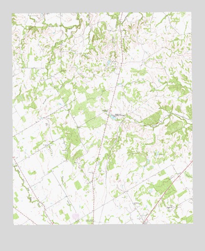
Knob Hill, TX USGS Topographic Map
Click on map above to begin viewing in our Map Viewer.

This topographic map contains these locations and features:
Feature Name Type Latitude Longitude GNIS ID View Map
Bethel CemeteryCemeteryN32.3354°W98.2270°1330482View Map
Bonham Lake Number 1ReservoirN32.2895°W98.1569°1863982View Map
Bonham Lake Number 1 DamDamN32.2901°W98.1570°1863981View Map
Bonham Lake Number 2ReservoirN32.2875°W98.1561°1863984View Map
Bonham Lake Number 2 DamDamN32.2885°W98.1570°1863983View Map
Center Grove SchoolSchoolN32.3168°W98.1842°1332528View Map
Collier LakeReservoirN32.3468°W98.1820°1863988View Map
Collier Lake DamDamN32.3468°W98.1820°1863987View Map
Henshaw CreekStreamN32.3726°W98.1762°1337628View Map
Knob HillPopulated PlaceN32.2590°W98.1431°1378532View Map
Knob Hill CemeteryCemeteryN32.2626°W98.1250°1339191View Map
Morton Chapel CemeteryCemeteryN32.3640°W98.1753°1341956View Map
Oak Dale ChurchChurchN32.2854°W98.2478°1342958View Map
Oak Dale Volunteer Fire DepartmentBuildingN32.2866°W98.2482°2551178View Map
Rough CreekStreamN32.3660°W98.2112°1375831View Map
Smith Springs CemeteryCemeteryN32.2543°W98.1598°1347297View Map
Smith Springs SchoolSchoolN32.2624°W98.1670°1347298View Map
Soil Conservation Service Site 5 DamDamN32.2935°W98.2470°1856034View Map
Soil Conservation Service Site 5 ReservoirReservoirN32.2935°W98.2470°1856035View Map
Soil Conservation Service Site 6 DamDamN32.2551°W98.2070°1856036View Map
Soil Conservation Service Site 6 ReservoirReservoirN32.2551°W98.2070°1856037View Map
Soil Conservation Service Site Number 6 DamDamN32.3501°W98.2037°1863600View Map
Soil Conservation Service Site Number 6 ReservoirReservoirN32.3501°W98.2037°1863601View Map
Stephenville Country Club LakeReservoirN32.3131°W98.1803°1347895View Map
Stephenville Country Club Lake DamDamN32.3135°W98.1787°1856032View Map
Straight CreekStreamN32.3743°W98.1970°1347988View Map
Terrell LakeReservoirN32.2696°W98.1547°1863986View Map
Terrell Lake DamDamN32.2701°W98.1537°1863985View Map
Texas A and M College Experimental StationSchoolN32.2524°W98.1937°1348393View Map
Wright CemeteryCemeteryN32.2865°W98.2053°1350609View Map

Note: Coordinates in the location and feature list above are referenced to NAD83 datum.


Copyright (C) 2008-2024 Ryan Niemi / Sunset Dynamics ... All Rights Reserved