TopoQuest Logo
Do you find TopoQuest useful?
Help keep TopoQuest running and adding new maps/features by donating!
Bitcoin:  19c7KJd3qBynnjoSw5npx9KScwjBe4ifkT
Litecoin:  LXs6TkuXGGXo1vDsWCkWVdjQX94eUKd6ui
Home View Maps Find Maps Find Places Resources & Links


La Salle, Colorado Topographic Map

USGS Map Title: La Salle, CO
USGS Map MRC: 40104C6
DRG (GeoTIFF) Download: o40104c6.tif


Neighboring USGS Topographic Map Quads:


  Bracewell, CO  
40104D7
 

  Greeley, CO  
40104D6
 

  Kersey, CO  
40104D5
 

  Milliken, CO  
40104C7
 

  La Salle, CO  
40104C6
 

  Valley View School, CO  
40104C5
 

  Platteville, CO  
40104B7
 

  Milton Reservoir, CO  
40104B6
 

  Klug Ranch, CO  
40104B5


Map MRC Location:

N41°
W105°
N41°
W104°
H8 H7 H6 H5 H4 H3 H2 H1
G8 G7 G6 G5 G4 G3 G2 G1
F8 F7 F6 F5 F4 F3 F2 F1
E8 E7 E6 E5 E4 E3 E2 E1
D8 D7 D6 D5 D4 D3 D2 D1
C8 C7 C6 C5 C4 C3 C2 C1
B8 B7 B6 B5 B4 B3 B2 B1
A8 A7 A6 A5 A4 A3 A2 A1
N40°
W105°
N40°
W104°

La Salle, CO USGS 1:24K Topographic Map Preview:
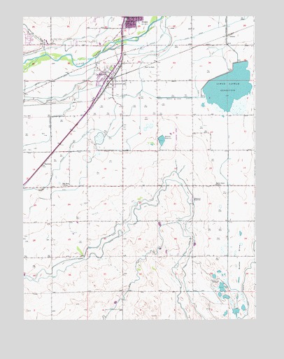
La Salle, CO USGS Topographic Map
Click on map above to begin viewing in our Map Viewer.

This topographic map contains these locations and features:
Feature Name Type Latitude Longitude GNIS ID View Map
Ashcroft DrawValleyN40.3597°W104.7376°180604View Map
AuburnPopulated PlaceN40.3680°W104.6366°180729View Map
Bebee DrawValleyN40.3268°W104.6393°180737View Map
Bebee Draw Gun ClubLocaleN40.2658°W104.6483°180730View Map
Bebee Draw SchoolSchoolN40.3053°W104.6464°180734View Map
Beebe Draw CemeteryCemeteryN40.2974°W104.6585°2736067View Map
Beebe Draw Pioneer CemeteryCemeteryN40.2618°W104.6400°2736058View Map
Behrens DamDamN40.3253°W104.6765°201046View Map
Behrens ReservoirReservoirN40.3241°W104.6753°180735View Map
Big Bend SchoolSchoolN40.3055°W104.7289°180732View Map
Chestnut ReservoirReservoirN40.2992°W104.6583°180733View Map
Colorado State Patrol District 3 Northeast ColoradoBuildingN40.3739°W104.6846°2736084View Map
East La SallePopulated PlaceN40.3547°W104.6825°180725View Map
Evans Fire and Rescue Station 1 East SideBuildingN40.3734°W104.6926°2667227View Map
Evans Number 2 DitchCanalN40.2803°W104.7098°2677362View Map
Evans Town DitchCanalN40.3607°W104.7412°2677363View Map
Evens Number 2 DitchCanalN40.3022°W104.6783°180721View Map
Evens Town DitchCanalN40.3611°W104.7394°202734View Map
Godfrey DitchCanalN40.3647°W104.7422°202743View Map
HambertPopulated PlaceN40.3150°W104.7380°180731View Map
KFKA-AM (Greeley)TowerN40.3655°W104.7327°204028View Map
La SallePopulated PlaceN40.3489°W104.7019°180726View Map
La Salle Fire DepartmentBuildingN40.3476°W104.7012°2666931View Map
La Salle Post OfficePost OfficeN40.3551°W104.6988°2736031View Map
La Salle-Gilcrest DivisionCivilN40.3044°W104.7277°1935507View Map
LaSalle Police DepartmentBuildingN40.3509°W104.7028°2709860View Map
Lower Latham DamDamN40.3566°W104.6372°198352View Map
Lower Latham DrainCanalN40.3583°W104.7311°180724View Map
Lower Latham OutletCanalN40.3747°W104.6375°202746View Map
Lower Latham ReservoirReservoirN40.3459°W104.6389°180728View Map
Miller Feed LotsLocaleN40.3367°W104.7306°2611969View Map
Milliken Fire Protection District Station 2BuildingN40.3646°W104.7486°2667345View Map
South Branch Union DitchCanalN40.3383°W104.6700°180727View Map
Town of La SalleCivilN40.3485°W104.7061°2412856View Map
Union DitchCanalN40.3419°W104.7061°202733View Map

Note: Coordinates in the location and feature list above are referenced to NAD83 datum.


Copyright (C) 2008-2024 Ryan Niemi / Sunset Dynamics ... All Rights Reserved