TopoQuest Logo
Do you find TopoQuest useful?
Help keep TopoQuest running and adding new maps/features by donating!
Bitcoin:  19c7KJd3qBynnjoSw5npx9KScwjBe4ifkT
Litecoin:  LXs6TkuXGGXo1vDsWCkWVdjQX94eUKd6ui
Home View Maps Find Maps Find Places Resources & Links


Laguna Seca, New Mexico Topographic Map

USGS Map Title: Laguna Seca, NM
USGS Map MRC: 35107D3
DRG (GeoTIFF) Download: o35107d3.tif


Neighboring USGS Topographic Map Quads:


  Mesa Cortada, NM  
35107E4
 

  Cerro Parido, NM  
35107E3
 

  Guadalupe, NM  
35107E2
 

  El Dado Mesa, NM  
35107D4
 

  Laguna Seca, NM  
35107D3
 

  Cerro Tinaja, NM  
35107D2
 

  Laguna Canoneros, NM  
35107C4
 

  Marquez, NM  
35107C3
 

  La Gotera, NM  
35107C2


Map MRC Location:

N36°
W108°
N36°
W107°
H8 H7 H6 H5 H4 H3 H2 H1
G8 G7 G6 G5 G4 G3 G2 G1
F8 F7 F6 F5 F4 F3 F2 F1
E8 E7 E6 E5 E4 E3 E2 E1
D8 D7 D6 D5 D4 D3 D2 D1
C8 C7 C6 C5 C4 C3 C2 C1
B8 B7 B6 B5 B4 B3 B2 B1
A8 A7 A6 A5 A4 A3 A2 A1
N35°
W108°
N35°
W107°

Laguna Seca, NM USGS 1:24K Topographic Map Preview:
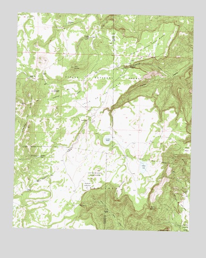
Laguna Seca, NM USGS Topographic Map
Click on map above to begin viewing in our Map Viewer.

This topographic map contains these locations and features:
Feature Name Type Latitude Longitude GNIS ID View Map
Black MesaSummitN35.4228°W107.2564°903871View Map
Cerrito Ojo FrioSummitN35.3878°W107.2756°904918View Map
Cerritos de la Jolla de Santa RosaSummitN35.4095°W107.3170°904921View Map
Cerro ColoradoSummitN35.3986°W107.3006°904964View Map
Cerro del DuraznoSummitN35.4550°W107.3487°904939View Map
Cerro MontosoSummitN35.4692°W107.3348°904978View Map
Cerros de GuadalupeRidgeN35.4336°W107.3667°905010View Map
Eagle NestPopulated PlaceN35.4384°W107.3245°905935View Map
Eagle Nest TankReservoirN35.4366°W107.3250°1988451View Map
Eduardo TankReservoirN35.4023°W107.3598°906016View Map
Escondido TankReservoirN35.4948°W107.3395°906190View Map
Evans WellWellN35.4648°W107.3562°937110View Map
Guadalupe CanyonValleyN35.4648°W107.2659°906758View Map
Guadalupe Ranger StationLocaleN35.4695°W107.2967°906766View Map
Guadalupe SpringSpringN35.4702°W107.2949°906768View Map
Guadalupe TankReservoirN35.4626°W107.3662°906771View Map
Horse Pasture Stock TankReservoirN35.4657°W107.3185°937111View Map
La Jolla AlfalfaFlatN35.4275°W107.3098°907666View Map
La Jolla de Santa RosaFlatN35.4011°W107.3239°907665View Map
Laguna del VinoReservoirN35.3969°W107.3663°907758View Map
Laguna SecaLakeN35.4119°W107.2841°907798View Map
Mariposa TankReservoirN35.4873°W107.3239°908417View Map
Marquez Wildlife AreaParkN35.4006°W107.3300°1988452View Map
Mesa de la Vereda Piedra BlancaSummitN35.4834°W107.2806°908605View Map
North SpringSpringN35.4165°W107.3641°909190View Map
Ojo de la CobraSpringN35.3857°W107.3083°909287View Map
Ojo EugenioSpringN35.3891°W107.3283°909315View Map
Ojo FrioSpringN35.3889°W107.2748°909316View Map
Piedra Blanca TankReservoirN35.4832°W107.2768°914155View Map
Pinabeta TankReservoirN35.4168°W107.3575°909642View Map
Valle de las AnimasValleyN35.4656°W107.2887°912034View Map

Note: Coordinates in the location and feature list above are referenced to NAD83 datum.


Copyright (C) 2008-2024 Ryan Niemi / Sunset Dynamics ... All Rights Reserved