TopoQuest Logo
Do you find TopoQuest useful?
Help keep TopoQuest running and adding new maps/features by donating!
Bitcoin:  19c7KJd3qBynnjoSw5npx9KScwjBe4ifkT
Litecoin:  LXs6TkuXGGXo1vDsWCkWVdjQX94eUKd6ui
Home View Maps Find Maps Find Places Resources & Links


Lake, Wyoming Topographic Map

USGS Map Title: Lake, WY
USGS Map MRC: 44110E4
DRG (GeoTIFF) Download: o44110e4.tif


Neighboring USGS Topographic Map Quads:


  Crystal Falls, WY  
44110F5
 

  Canyon Village, WY  
44110F4
 

  White Lake, WY  
44110F3
 

  Beach Lake, WY  
44110E5
 

  Lake, WY  
44110E4
 

  Lake Butte, WY  
44110E3
 

  West Thumb, WY  
44110D5
 

  Dot Island, WY  
44110D4
 

  Frank Island, WY  
44110D3


Map MRC Location:

N45°
W111°
N45°
W110°
H8 H7 H6 H5 H4 H3 H2 H1
G8 G7 G6 G5 G4 G3 G2 G1
F8 F7 F6 F5 F4 F3 F2 F1
E8 E7 E6 E5 E4 E3 E2 E1
D8 D7 D6 D5 D4 D3 D2 D1
C8 C7 C6 C5 C4 C3 C2 C1
B8 B7 B6 B5 B4 B3 B2 B1
A8 A7 A6 A5 A4 A3 A2 A1
N44°
W111°
N44°
W110°

Lake, WY USGS 1:24K Topographic Map Preview:
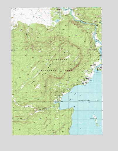
Lake, WY USGS Topographic Map
Click on map above to begin viewing in our Map Viewer.

This topographic map contains these locations and features:
Feature Name Type Latitude Longitude GNIS ID View Map
Black Dragons CaldronSpringN44.6202°W110.4355°1585590View Map
Bridge BayBayN44.5333°W110.4230°1585901View Map
Bridge CreekStreamN44.5299°W110.4341°1585903View Map
Elephant Back Loop TrailTrailN44.5683°W110.4149°1588206View Map
Elephant Back MountainSummitN44.5720°W110.4403°1588207View Map
Gull PointCliffN44.5274°W110.4166°1589188View Map
LakePopulated PlaceN44.5583°W110.3966°1609217View Map
Lake HotelBuildingN44.5497°W110.4010°1597375View Map
Lake JunctionLocaleN44.5683°W110.3874°1597376View Map
Lake LodgeLocaleN44.5549°W110.3960°1590477View Map
Lake Outlet Post OfficePost OfficeN44.5583°W110.3966°1609216View Map
Lake Ranger StationLocaleN44.5511°W110.3955°1590480View Map
LeHardys RapidsRapidsN44.6073°W110.3840°1590604View Map
Mud GeyserSpringN44.6247°W110.4342°1609275View Map
Mud VolcanoSpringN44.6231°W110.4319°1591866View Map
Nez Perce FordCrossingN44.6180°W110.4169°1609370View Map
Obsidian PoolSpringN44.6105°W110.4399°1890227View Map
Ochre SpringsSpringN44.6030°W110.3974°1592356View Map
Stevenson IslandIslandN44.5152°W110.3852°1609303View Map
Thistle CreekStreamN44.6077°W110.3863°1596969View Map
Weasel CreekStreamN44.5136°W110.4171°1596097View Map
Yellowstone National Park Fire Department Lake StationBuildingN44.5630°W110.3979°2673532View Map
Yellowstone Natural BridgeArchN44.5263°W110.4566°1591964View Map

Note: Coordinates in the location and feature list above are referenced to NAD83 datum.


Copyright (C) 2008-2024 Ryan Niemi / Sunset Dynamics ... All Rights Reserved