TopoQuest Logo
Do you find TopoQuest useful?
Help keep TopoQuest running and adding new maps/features by donating!
Bitcoin:  19c7KJd3qBynnjoSw5npx9KScwjBe4ifkT
Litecoin:  LXs6TkuXGGXo1vDsWCkWVdjQX94eUKd6ui
Home View Maps Find Maps Find Places Resources & Links


Lake Abilene, Texas Topographic Map

USGS Map Title: Lake Abilene, TX
USGS Map MRC: 32099B8
DRG (GeoTIFF) Download: o32099b8.tif


Neighboring USGS Topographic Map Quads:


  Mountain Pass, TX  
32100C1
 

  View, TX  
32099C8
 

  Buffalo Gap, TX  
32099C7
 

  Shep, TX  
32100B1
 

  Lake Abilene, TX  
32099B8
 

  Tuscola, TX  
32099B7
 

  Wingate, TX  
32100A1
 

  Bradshaw, TX  
32099A8
 

  Bald Knob, TX  
32099A7


Map MRC Location:

N33°
W100°
N33°
W99°
H8 H7 H6 H5 H4 H3 H2 H1
G8 G7 G6 G5 G4 G3 G2 G1
F8 F7 F6 F5 F4 F3 F2 F1
E8 E7 E6 E5 E4 E3 E2 E1
D8 D7 D6 D5 D4 D3 D2 D1
C8 C7 C6 C5 C4 C3 C2 C1
B8 B7 B6 B5 B4 B3 B2 B1
A8 A7 A6 A5 A4 A3 A2 A1
N32°
W100°
N32°
W99°

Lake Abilene, TX USGS 1:24K Topographic Map Preview:
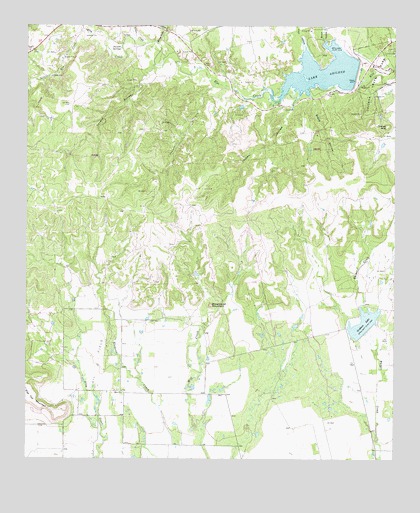
Lake Abilene, TX USGS Topographic Map
Click on map above to begin viewing in our Map Viewer.

This topographic map contains these locations and features:
Feature Name Type Latitude Longitude GNIS ID View Map
Abilene State ParkParkN32.2354°W99.8801°1329177View Map
Abilene State Park TrailTrailN32.2354°W99.8801°2032980View Map
Brock HollowValleyN32.2438°W99.8978°1331294View Map
Cedar CreekStreamN32.2449°W99.9598°1332412View Map
Coon HollowValleyN32.2409°W99.9053°1333290View Map
Elm Creek Citizens Association Volunteer Fire Department Station 2BuildingN32.2204°W99.9393°2551242View Map
Graham LakeReservoirN32.1643°W99.8857°1859555View Map
Horse Fall CreekStreamN32.2449°W99.9559°1338103View Map
Indian MountainSummitN32.2212°W99.8779°1338445View Map
Jordan HollowValleyN32.2271°W99.9101°1338877View Map
Lake AbileneReservoirN32.2372°W99.8979°1329178View Map
Lake Abilene DamDamN32.2351°W99.8887°1859556View Map
Lake Bulger DamDamN32.1618°W99.8854°1859554View Map
Little Elm CreekStreamN32.2482°W99.9818°1340091View Map
Pleasant RunStreamN32.2332°W99.9356°1344241View Map
Puckett SpringsSpringN32.2435°W99.9687°1344617View Map
Scott HollowValleyN32.2304°W99.9043°1346818View Map
Steamboat MountainSummitN32.1693°W99.9376°1347842View Map
Tenant HollowValleyN32.2390°W99.9573°1348357View Map

Note: Coordinates in the location and feature list above are referenced to NAD83 datum.


Copyright (C) 2008-2025 Ryan Niemi / Sunset Dynamics ... All Rights Reserved