TopoQuest Logo
Do you find TopoQuest useful?
Help keep TopoQuest running and adding new maps/features by donating!
Bitcoin:  19c7KJd3qBynnjoSw5npx9KScwjBe4ifkT
Litecoin:  LXs6TkuXGGXo1vDsWCkWVdjQX94eUKd6ui
Home View Maps Find Maps Find Places Resources & Links


Lake Carl Blackwell, Oklahoma Topographic Map

USGS Map Title: Lake Carl Blackwell, OK
USGS Map MRC: 36097B2
DRG (GeoTIFF) Download: o36097b2.tif


Neighboring USGS Topographic Map Quads:


  Perry, OK  
36097C3
 

  Black Bear, OK  
36097C2
 

  Morrison, OK  
36097C1
 

  Orlando East, OK  
36097B3
 

  Lake Carl Blackwell, OK  
36097B2
 

  Stillwater North, OK  
36097B1
 

  Clear Creek, OK  
36097A3
 

  Stillwater SW, OK  
36097A2
 

  Stillwater South, OK  
36097A1


Map MRC Location:

N37°
W98°
N37°
W97°
H8 H7 H6 H5 H4 H3 H2 H1
G8 G7 G6 G5 G4 G3 G2 G1
F8 F7 F6 F5 F4 F3 F2 F1
E8 E7 E6 E5 E4 E3 E2 E1
D8 D7 D6 D5 D4 D3 D2 D1
C8 C7 C6 C5 C4 C3 C2 C1
B8 B7 B6 B5 B4 B3 B2 B1
A8 A7 A6 A5 A4 A3 A2 A1
N36°
W98°
N36°
W97°

Lake Carl Blackwell, OK USGS 1:24K Topographic Map Preview:
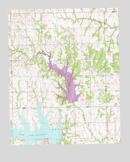
Lake Carl Blackwell, OK USGS Topographic Map
Click on map above to begin viewing in our Map Viewer.

This topographic map contains these locations and features:
Feature Name Type Latitude Longitude GNIS ID View Map
Carl Blackwell DamDamN36.1350°W97.1920°1757357View Map
Doxey CemeteryCemeteryN36.2022°W97.1775°2705795View Map
Dry CreekStreamN36.1309°W97.1411°1092222View Map
Ewy CemeteryCemeteryN36.2461°W97.2040°2705796View Map
Harrington CreekStreamN36.1273°W97.1650°1093567View Map
Lake Carl BlackwellReservoirN36.1359°W97.2282°1090964View Map
Lake McMurtryReservoirN36.1819°W97.1853°1095277View Map
Lanier CemeteryCemeteryN36.1881°W97.1398°1094510View Map
Long Branch Site 3 DamDamN36.2200°W97.1303°1755167View Map
Long Branch Site 3 ReservoirReservoirN36.2200°W97.1303°1755168View Map
North Stillwater CreekStreamN36.1298°W97.1536°1096007View Map
Oknoname 103004 DamDamN36.2234°W97.1637°1753507View Map
Oknoname 103004 ReservoirReservoirN36.2231°W97.1650°1753508View Map
Shelton-Bethel CemeteryCemeteryN36.1597°W97.2126°1097984View Map
South Lone Elm Oil FieldOilfieldN36.2039°W97.2362°1098263View Map
Stillwater Creek Site 34 DamDamN36.1367°W97.1270°1752235View Map
Stillwater Creek Site 34 ReservoirReservoirN36.1354°W97.1288°1752236View Map
Stillwater Creek Site 35 DamDamN36.1350°W97.1386°1752237View Map
Stillwater Creek Site 35 ReservoirReservoirN36.1360°W97.1388°1752238View Map
Stillwater Creek Site 37 DamDamN36.1750°W97.1453°1757433View Map
Stillwater Creek Site 37 ReservoirReservoirN36.1755°W97.1451°1757434View Map
Stillwater Creek Site 38 DamDamN36.1917°W97.1470°1757435View Map
Stillwater Creek Site 38 ReservoirReservoirN36.1911°W97.1466°1757436View Map
Stillwater Creek Site 39 DamDamN36.1934°W97.1570°1757437View Map
Stillwater Creek Site 39 ReservoirReservoirN36.1943°W97.1571°1757438View Map
Stillwater Creek Site 40 DamDamN36.1800°W97.1786°1757439View Map
Stillwater Creek Site 41 DamDamN36.2037°W97.1824°1757441View Map
Stillwater Creek Site 41 ReservoirReservoirN36.2056°W97.1814°1757442View Map
Township of StillwaterCivilN36.1417°W97.1309°1824854View Map
Township of WalnutCivilN36.2028°W97.1920°1824807View Map

Note: Coordinates in the location and feature list above are referenced to NAD83 datum.


Copyright (C) 2008-2025 Ryan Niemi / Sunset Dynamics ... All Rights Reserved