TopoQuest Logo
Do you find TopoQuest useful?
Help keep TopoQuest running and adding new maps/features by donating!
Bitcoin:  19c7KJd3qBynnjoSw5npx9KScwjBe4ifkT
Litecoin:  LXs6TkuXGGXo1vDsWCkWVdjQX94eUKd6ui
Home View Maps Find Maps Find Places Resources & Links


Lake City, Colorado Topographic Map

USGS Map Title: Lake City, CO
USGS Map MRC: 38107A3
DRG (GeoTIFF) Download: o38107a3.tif


Neighboring USGS Topographic Map Quads:


  Sheep Mountain, CO  
38107B4
 

  Alpine Plateau, CO  
38107B3
 

  Powderhorn Lakes, CO  
38107B2
 

  Uncompahgre Peak, CO  
38107A4
 

  Lake City, CO  
38107A3
 

  Cannibal Plateau, CO  
38107A2
 

  Redcloud Peak, CO  
37107H4
 

  Lake San Cristobal, CO  
37107H3
 

  Slumgullion Pass, CO  
37107H2


Map MRC Location:

N39°
W108°
N39°
W107°
H8 H7 H6 H5 H4 H3 H2 H1
G8 G7 G6 G5 G4 G3 G2 G1
F8 F7 F6 F5 F4 F3 F2 F1
E8 E7 E6 E5 E4 E3 E2 E1
D8 D7 D6 D5 D4 D3 D2 D1
C8 C7 C6 C5 C4 C3 C2 C1
B8 B7 B6 B5 B4 B3 B2 B1
A8 A7 A6 A5 A4 A3 A2 A1
N38°
W108°
N38°
W107°

Lake City, CO USGS 1:24K Topographic Map Preview:
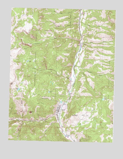
Lake City, CO USGS Topographic Map
Click on map above to begin viewing in our Map Viewer.

This topographic map contains these locations and features:
Feature Name Type Latitude Longitude GNIS ID View Map
Alpine GulchValleyN38.0188°W107.3586°187416View Map
Belle of the East MineMineN38.0031°W107.2839°188725View Map
Belle of the West MineMineN38.0014°W107.2856°188724View Map
Big Casino Number Two MineMineN38.1078°W107.3159°1745640View Map
Bill Hare GulchValleyN38.1106°W107.2942°188732View Map
California MineMineN38.0197°W107.3720°188696View Map
Cleveland MineMineN38.0186°W107.3317°188719View Map
Cora MineMineN38.0078°W107.3003°188718View Map
Crooke FallsFallsN38.0142°W107.3117°188716View Map
Crystal CreekStreamN38.0192°W107.3595°188703View Map
Crystal LakeLakeN38.0482°W107.3644°188694View Map
Crystal PeakSummitN38.0536°W107.3739°188695View Map
Dauphin MineMineN38.0056°W107.3145°1745642View Map
Dawn of Hope MineMineN38.0308°W107.3112°1745643View Map
Deadman GulchValleyN38.0007°W107.2958°188705View Map
Eaton CreekStreamN38.0847°W107.2934°188712View Map
Fanny Fern MineMineN38.0150°W107.3378°188700View Map
Frank B Watters DamDamN38.0883°W107.2923°198654View Map
Frank B Watters ReservoirReservoirN38.0883°W107.2923°198655View Map
Friends CreekStreamN38.0722°W107.2984°188706View Map
Galena MineMineN38.0583°W107.3187°1745645View Map
Golden Wonder MineMineN38.0047°W107.2806°188726View Map
Happy Day MineMineN38.0308°W107.3112°1745646View Map
Hay LakeLakeN38.0440°W107.3467°188704View Map
Henson CreekStreamN38.0256°W107.3145°187344View Map
Hidden Treasure MineMineN38.0253°W107.3689°188697View Map
Hinsdale County Emergency Medical ServiceBuildingN38.0303°W107.3134°2716977View Map
Hinsdale County Sheriff's OfficeBuildingN38.0288°W107.3148°2757258View Map
Hobo GulchValleyN38.1179°W107.2938°188731View Map
Hoosier Boy MineMineN38.0308°W107.3112°1745647View Map
Horse ParkFlatN38.0250°W107.2839°188723View Map
Independence GulchValleyN38.0947°W107.2924°188691View Map
Lake CityPopulated PlaceN38.0300°W107.3153°188715View Map
Lake City Post OfficePost OfficeN38.0350°W107.3132°2750957View Map
Lake City Volunteer Fire DepartmentBuildingN38.0269°W107.3159°2667349View Map
Larson CreekStreamN38.0303°W107.2989°188710View Map
Larson LakesLakeN38.0747°W107.3542°188713View Map
Lellie MineMineN38.0069°W107.3159°1745633View Map
Monte Queen MineMineN38.0308°W107.3112°1745639View Map
Neoga MountainSummitN38.0333°W107.3423°188702View Map
New CemeteryCemeteryN38.0425°W107.3109°188728View Map
Nourse CreekStreamN38.1131°W107.2934°188711View Map
Old CemeteryCemeteryN38.0375°W107.3067°188727View Map
Palmetto MineMineN38.0308°W107.3112°1745648View Map
Park CreekStreamN38.0053°W107.3017°188721View Map
Pelican MineMineN38.0244°W107.3403°188701View Map
Rodney Number One MineMineN38.0308°W107.3112°1745649View Map
San Juan RanchLocaleN38.0444°W107.3034°188707View Map
Slaughterhouse GulchValleyN38.0366°W107.3148°188720View Map
Sparling GulchValleyN38.0706°W107.2923°188733View Map
Station ElevenSummitN38.0250°W107.2967°188729View Map
Stony CutValleyN38.1006°W107.2902°188730View Map
Sugarloaf RockPillarN38.0272°W107.3495°188699View Map
Swanson Airport (historical)AirportN38.0772°W107.2914°196896View Map
T GulchValleyN38.0182°W107.3740°188693View Map
Thompson LakeLakeN38.0463°W107.3277°188709View Map
Town of Lake CityCivilN38.0302°W107.3104°2412863View Map
Treasure FallsFallsN38.0193°W107.3623°188698View Map
Ulay MineMineN38.0175°W107.3642°1745650View Map
Ute MineMineN38.0197°W107.3737°1745651View Map
V C Bar RanchLocaleN38.0931°W107.2895°188714View Map
Valley View RanchLocaleN38.0603°W107.3042°188708View Map
Vickers RanchLocaleN38.0067°W107.3048°188717View Map
Wade GulchValleyN38.0187°W107.3168°187435View Map
Waterdog LakeReservoirN38.0408°W107.2629°188722View Map

Note: Coordinates in the location and feature list above are referenced to NAD83 datum.


Copyright (C) 2008-2024 Ryan Niemi / Sunset Dynamics ... All Rights Reserved