TopoQuest Logo
Do you find TopoQuest useful?
Help keep TopoQuest running and adding new maps/features by donating!
Bitcoin:  19c7KJd3qBynnjoSw5npx9KScwjBe4ifkT
Litecoin:  LXs6TkuXGGXo1vDsWCkWVdjQX94eUKd6ui
Home View Maps Find Maps Find Places Resources & Links


Afton NE, Oklahoma Topographic Map

USGS Map Title: Afton NE, OK
USGS Map MRC: 36094F7
DRG (GeoTIFF) Download: o36094f7.tif


Neighboring USGS Topographic Map Quads:


  Miami SW, OK  
36094G8
 

  Miami SE, OK  
36094G7
 

  Wyandotte, OK  
36094G6
 

  Afton, OK  
36094F8
 

  Afton NE, OK  
36094F7
 

  Cayuga, OK  
36094F6
 

  Bernice, OK  
36094E8
 

  Grove, OK  
36094E7
 

  Dodge, OK  
36094E6


Map MRC Location:

N37°
W95°
N37°
W94°
H8 H7 H6 H5 H4 H3 H2 H1
G8 G7 G6 G5 G4 G3 G2 G1
F8 F7 F6 F5 F4 F3 F2 F1
E8 E7 E6 E5 E4 E3 E2 E1
D8 D7 D6 D5 D4 D3 D2 D1
C8 C7 C6 C5 C4 C3 C2 C1
B8 B7 B6 B5 B4 B3 B2 B1
A8 A7 A6 A5 A4 A3 A2 A1
N36°
W95°
N36°
W94°

Afton NE, OK USGS 1:24K Topographic Map Preview:
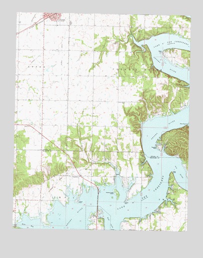
Afton NE, OK USGS Topographic Map
Click on map above to begin viewing in our Map Viewer.

This topographic map contains these locations and features:
Feature Name Type Latitude Longitude GNIS ID View Map
Afton-Fairland DivisionCivilN36.7236°W94.8684°1937630View Map
Bee CreekStreamN36.7370°W94.7908°1089963View Map
Catfish PointCapeN36.6406°W94.8286°1091041View Map
Cave SpringSpringN36.7490°W94.7519°1091050View Map
City of Fairland Fire Department Station 1BuildingN36.7499°W94.8483°2656960View Map
CopelandCivilN36.6571°W94.8204°2631092View Map
CopelandPopulated PlaceN36.6559°W94.8283°1100319View Map
Copeland Census Designated PlaceCensusN36.6571°W94.8205°2407657View Map
Echo BayBayN36.6279°W94.8644°1092473View Map
Elk RiverStreamN36.6656°W94.7675°1092538View Map
Fairland CemeteryCemeteryN36.7443°W94.8362°1092695View Map
Fairland Post OfficePost OfficeN36.7492°W94.8533°1814043View Map
Fairland Volunteer Fire Department Station 2BuildingN36.7383°W94.8559°2657498View Map
Green Country AirparkAirportN36.7151°W94.8528°1102469View Map
Hickory CreekStreamN36.6592°W94.8008°1093699View Map
Hickory Creek IslandIslandN36.6470°W94.8011°1093707View Map
Hickory Grove CemeteryCemeteryN36.6659°W94.8116°1093711View Map
Hickory Grove ChurchChurchN36.6598°W94.8194°1093713View Map
Hickory Grove Fire DepartmentBuildingN36.6557°W94.8067°2657265View Map
Hickory PointCapeN36.6420°W94.7947°1093718View Map
Midway ChurchChurchN36.6842°W94.8647°1095381View Map
Osage HollowValleyN36.7095°W94.7502°1096321View Map
Paradise PointCapeN36.6742°W94.7727°1096428View Map
Paradise Point Fire StationBuildingN36.6737°W94.7696°2657398View Map
Reed PointCapeN36.6590°W94.7616°1097150View Map
Sail Boat BridgeBridgeN36.6429°W94.8144°1097576View Map
Saint Elizabeth MissionChurchN36.6323°W94.8172°1097587View Map
Saint Paul Lutheran CemeteryCemeteryN36.7439°W94.8356°2760998View Map
Sulphur BendBendN36.6948°W94.7608°1098618View Map
Sulphur Bend CemeteryCemeteryN36.6989°W94.7965°1098619View Map
Wilson PointCapeN36.7287°W94.7694°1099896View Map
Wolf CreekStreamN36.6354°W94.8066°1099960View Map

Note: Coordinates in the location and feature list above are referenced to NAD83 datum.


Copyright (C) 2008-2025 Ryan Niemi / Sunset Dynamics ... All Rights Reserved