TopoQuest Logo
Do you find TopoQuest useful?
Help keep TopoQuest running and adding new maps/features by donating!
Bitcoin:  19c7KJd3qBynnjoSw5npx9KScwjBe4ifkT
Litecoin:  LXs6TkuXGGXo1vDsWCkWVdjQX94eUKd6ui
Home View Maps Find Maps Find Places Resources & Links


Lake McDonald West, Montana Topographic Map

USGS Map Title: Lake McDonald West, MT
USGS Map MRC: 48113E8
DRG (GeoTIFF) Download: o48113e8.tif


Neighboring USGS Topographic Map Quads:


  Camas Ridge West, MT  
48114F1
 

  Camas Ridge East, MT  
48113F8
 

  Mount Cannon, MT  
48113F7
 

  McGee Meadow, MT  
48114E1
 

  Lake McDonald West, MT  
48113E8
 

  Lake McDonald East, MT  
48113E7
 

  Hungry Horse, MT  
48114D1
 

  West Glacier, MT  
48113D8
 

  Nyack, MT  
48113D7


Map MRC Location:

N49°
W114°
N49°
W113°
H8 H7 H6 H5 H4 H3 H2 H1
G8 G7 G6 G5 G4 G3 G2 G1
F8 F7 F6 F5 F4 F3 F2 F1
E8 E7 E6 E5 E4 E3 E2 E1
D8 D7 D6 D5 D4 D3 D2 D1
C8 C7 C6 C5 C4 C3 C2 C1
B8 B7 B6 B5 B4 B3 B2 B1
A8 A7 A6 A5 A4 A3 A2 A1
N48°
W114°
N48°
W113°

Lake McDonald West, MT USGS 1:24K Topographic Map Preview:
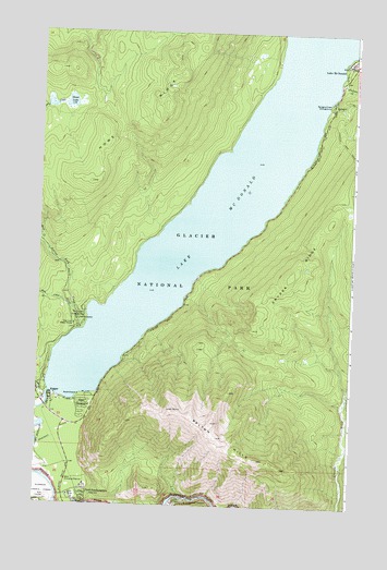
Lake McDonald West, MT USGS Topographic Map
Click on map above to begin viewing in our Map Viewer.

This topographic map contains these locations and features:
Feature Name Type Latitude Longitude GNIS ID View Map
32N19W26BBCD01 WellWellN48.5125°W113.9993°1635778View Map
ApgarPopulated PlaceN48.5277°W113.9932°779098View Map
Apgar CampgroundLocaleN48.5266°W113.9810°798956View Map
Apgar CreekStreamN48.5280°W113.9960°779099View Map
Apgar Post Office (historical)Post OfficeN48.5277°W113.9932°1796083View Map
Apgar School (historical)SchoolN48.5277°W113.9932°1796082View Map
Belton HillsSummitN48.5220°W113.9299°779680View Map
Fern CreekStreamN48.5527°W113.9862°783358View Map
Fish CreekStreamN48.5461°W113.9815°783434View Map
Fish Creek CampgroundLocaleN48.5500°W113.9829°1795929View Map
Fish Creek Ranger StationLocaleN48.5475°W113.9848°798982View Map
Glacier National Park Fire BrigadeBuildingN48.5024°W113.9865°2546729View Map
Glacier National Park HeadquartersLocaleN48.5027°W113.9854°783971View Map
Glacier National Park Law EnforcementBuildingN48.5024°W113.9865°2548926View Map
Glacier View Golf ClubLocaleN48.5041°W113.9982°1795941View Map
Howe LakeLakeN48.6062°W113.9884°785109View Map
Jackson CreekStreamN48.6125°W113.8818°785391View Map
Lake McDonaldLakeN48.5835°W113.9259°787038View Map
Lake McDonald HotelLocaleN48.6175°W113.8790°794251View Map
Snyder CreekStreamN48.6177°W113.8804°790816View Map
Snyder RidgeRidgeN48.5604°W113.9005°790820View Map
South Boundary TrailTrailN48.5033°W113.9337°790881View Map
Sprague CreekStreamN48.6080°W113.8840°791186View Map
Sprague Creek CampgroundLocaleN48.6072°W113.8843°799023View Map
West Entrance StationLocaleN48.5069°W113.9871°792968View Map

Note: Coordinates in the location and feature list above are referenced to NAD83 datum.


Copyright (C) 2008-2025 Ryan Niemi / Sunset Dynamics ... All Rights Reserved