TopoQuest Logo
Do you find TopoQuest useful?
Help keep TopoQuest running and adding new maps/features by donating!
Bitcoin:  19c7KJd3qBynnjoSw5npx9KScwjBe4ifkT
Litecoin:  LXs6TkuXGGXo1vDsWCkWVdjQX94eUKd6ui
Home View Maps Find Maps Find Places Resources & Links


Lake Mechant, Louisiana Topographic Map

USGS Map Title: Lake Mechant, LA
USGS Map MRC: 29090C8
DRG (GeoTIFF) Download: o29090c8.tif


Neighboring USGS Topographic Map Quads:


  Lake Penchant, LA  
29090D8
 

  Lake Theriot, LA  
29090D7
 

  Lost Lake, LA  
29091C1
 

  Lake Mechant, LA  
29090C8
 

  Bayou Sauveur, LA  
29090C7


  Grand Bayou du Large, LA  
29090B8
 

  Dog Lake, LA  
29090B7


Map MRC Location:

N30°
W91°
N30°
W90°
H8 H7 H6 H5 H4 H3 H2 H1
G8 G7 G6 G5 G4 G3 G2 G1
F8 F7 F6 F5 F4 F3 F2 F1
E8 E7 E6 E5 E4 E3 E2 E1
D8 D7 D6 D5 D4 D3 D2 D1
C8 C7 C6 C5 C4 C3 C2 C1
B8 B7 B6 B5 B4 B3 B2 B1
A8 A7 A6 A5 A4 A3 A2 A1
N29°
W91°
N29°
W90°

Lake Mechant, LA USGS 1:24K Topographic Map Preview:
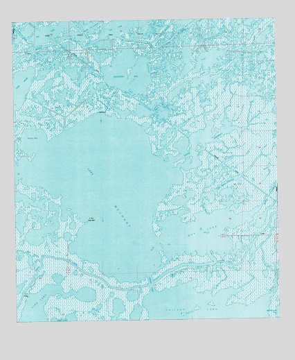
Lake Mechant, LA USGS Topographic Map
Click on map above to begin viewing in our Map Viewer.

This topographic map contains these locations and features:
Feature Name Type Latitude Longitude GNIS ID View Map
Bay LongBayN29.3721°W90.9828°553389View Map
Bayou ChevreauBayN29.3249°W90.9099°532513View Map
Bayou De CadeBayN29.3652°W90.9630°558148View Map
Bayou du LargeBayN29.2846°W90.8875°532572View Map
Bayou DufreneBayN29.3048°W90.8777°532576View Map
Bayou la LoutreBayN29.3750°W90.9625°532422View Map
Deer BayouBayN29.2998°W90.9088°534456View Map
Dominick BayouBayN29.2639°W90.9986°534558View Map
Fred BayouBayN29.3148°W90.9014°535093View Map
Goose BayBayN29.3257°W90.9913°554553View Map
Grand PassBayN29.2651°W90.9360°535342View Map
Hog PointCapeN29.2919°W90.9654°535703View Map
Jug LakeBayN29.3744°W90.9460°554905View Map
Lake MechantBayN29.3022°W90.9663°558267View Map
Lake PagieBayN29.3431°W90.9994°555582View Map
Lake WashaLakeN29.3024°W90.9984°556365View Map
Little Bayou ChevreauBayN29.3069°W90.8997°536485View Map
Mud LakeBayN29.2858°W90.9116°555429View Map
Parish Governing Authority District 7CivilN29.3132°W90.9580°1930221View Map
Parish Governing Authority District I (historical)CivilN29.3188°W90.9920°1930334View Map
Raccourci BayBayN29.3526°W90.9393°555749View Map
Raccourci BayouBayN29.3360°W90.9483°538471View Map
Small Bayou La PointeStreamN29.3424°W90.9332°539420View Map
Voss CanalBayN29.3728°W90.9992°540183View Map

Note: Coordinates in the location and feature list above are referenced to NAD83 datum.


Copyright (C) 2008-2024 Ryan Niemi / Sunset Dynamics ... All Rights Reserved