TopoQuest Logo
Do you find TopoQuest useful?
Help keep TopoQuest running and adding new maps/features by donating!
Bitcoin:  19c7KJd3qBynnjoSw5npx9KScwjBe4ifkT
Litecoin:  LXs6TkuXGGXo1vDsWCkWVdjQX94eUKd6ui
Home View Maps Find Maps Find Places Resources & Links


Barnsdall, Oklahoma Topographic Map

USGS Map Title: Barnsdall, OK
USGS Map MRC: 36096E2
DRG (GeoTIFF) Download: o36096e2.tif


Neighboring USGS Topographic Map Quads:


  Pawhuska, OK  
36096F3
 

  Nelagoney, OK  
36096F2
 

  Woolaroc, OK  
36096F1
 

  Wynona, OK  
36096E3
 

  Barnsdall, OK  
36096E2
 

  Wolco, OK  
36096E1
 

  Hominy NE, OK  
36096D3
 

  Avant NW, OK  
36096D2
 

  Avant, OK  
36096D1


Map MRC Location:

N37°
W97°
N37°
W96°
H8 H7 H6 H5 H4 H3 H2 H1
G8 G7 G6 G5 G4 G3 G2 G1
F8 F7 F6 F5 F4 F3 F2 F1
E8 E7 E6 E5 E4 E3 E2 E1
D8 D7 D6 D5 D4 D3 D2 D1
C8 C7 C6 C5 C4 C3 C2 C1
B8 B7 B6 B5 B4 B3 B2 B1
A8 A7 A6 A5 A4 A3 A2 A1
N36°
W97°
N36°
W96°

Barnsdall, OK USGS 1:24K Topographic Map Preview:
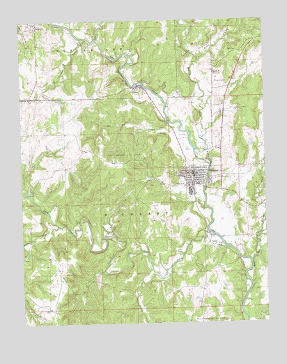
Barnsdall, OK USGS Topographic Map
Click on map above to begin viewing in our Map Viewer.

This topographic map contains these locations and features:
Feature Name Type Latitude Longitude GNIS ID View Map
BarnsdallPopulated PlaceN36.5620°W96.1617°1089868View Map
Barnsdall City CemeteryCemeteryN36.5614°W96.1447°2705799View Map
Barnsdall DivisionCivilN36.5222°W96.1369°1937642View Map
Barnsdall Elementary SchoolSchoolN36.5589°W96.1685°1089870View Map
Barnsdall Fire DepartmentBuildingN36.5613°W96.1484°2657346View Map
Barnsdall High SchoolSchoolN36.5601°W96.1666°2713136View Map
Barnsdall Junior High SchoolSchoolN36.5602°W96.1666°2712844View Map
Barnsdall Oil FieldOilfieldN36.5576°W96.1508°1089869View Map
Barnsdall Police StationBuildingN36.5620°W96.1611°2757785View Map
Barnsdall Rural Fire FightersBuildingN36.5575°W96.1620°2656838View Map
Birch CreekStreamN36.5359°W96.1511°1090147View Map
Birch Creek Oil FieldOilfieldN36.5176°W96.2306°1090149View Map
Birch Creek South Oil FieldOilfieldN36.5034°W96.2472°1090150View Map
Birch DamDamN36.5351°W96.1586°1754452View Map
Birch LakeReservoirN36.5301°W96.1660°1754453View Map
Birch ReservoirReservoirN36.5290°W96.1742°1763728View Map
Cedar CreekStreamN36.6173°W96.2106°1091099View Map
Choteau CreekStreamN36.5712°W96.1608°1091331View Map
Christian ChurchChurchN36.5112°W96.1625°1778663View Map
City of BarnsdallCivilN36.5607°W96.1627°2409788View Map
Cochahee CreekStreamN36.6173°W96.2158°1091530View Map
Dog Thresher CreekStreamN36.5254°W96.1328°1092134View Map
East Choteau CreekStreamN36.5795°W96.1556°1092377View Map
East Pershing Oil FieldOilfieldN36.6162°W96.2469°1092429View Map
Fort Gibson DamDamN36.5351°W96.1586°1751412View Map
Fourmile CreekStreamN36.5406°W96.2320°1092996View Map
Free Will Baptist ChurchChurchN36.5581°W96.1583°1778664View Map
GillandPopulated PlaceN36.5331°W96.1542°1100449View Map
James Bigheart CemeteryCemeteryN36.5553°W96.1512°2705801View Map
Javine CemeteryCemeteryN36.5896°W96.1514°1094181View Map
Nelagoney CemeteryCemeteryN36.6168°W96.2366°2705804View Map
Nelagoney Rural Volunteer Fire DepartmentBuildingN36.6228°W96.2425°2656909View Map
NicholsPopulated PlaceN36.5201°W96.1381°1763727View Map
Oknoname 113071 DamDamN36.5517°W96.1503°1753770View Map
Oknoname 113071 ReservoirReservoirN36.5526°W96.1509°1753771View Map
Oknoname 113072 DamDamN36.5517°W96.1386°1753772View Map
Oknoname 113072 ReservoirReservoirN36.5527°W96.1383°1753773View Map
Oknoname 113073 DamDamN36.5734°W96.1319°1753774View Map
Oknoname 113073 ReservoirReservoirN36.5741°W96.1318°1753775View Map
Pennel CreekStreamN36.6087°W96.1589°1096540View Map
Quapaw Oil FieldOilfieldN36.6145°W96.1572°1096984View Map
Red Eagle BranchStreamN36.5829°W96.1739°1097092View Map
Red Eagle CemeteryCemeteryN36.5783°W96.1753°1097093View Map
Reece CemeteryCemeteryN36.5597°W96.1497°1097144View Map
TallantPopulated PlaceN36.5976°W96.1906°1098738View Map
Township of BigheartCivilN36.5445°W96.1919°1824834View Map
United Methodist ChurchChurchN36.5606°W96.1642°1778665View Map
West Barnsdall Oil FieldOilfieldN36.5684°W96.1978°1099504View Map

Note: Coordinates in the location and feature list above are referenced to NAD83 datum.


Copyright (C) 2008-2024 Ryan Niemi / Sunset Dynamics ... All Rights Reserved