TopoQuest Logo
Do you find TopoQuest useful?
Help keep TopoQuest running and adding new maps/features by donating!
Bitcoin:  19c7KJd3qBynnjoSw5npx9KScwjBe4ifkT
Litecoin:  LXs6TkuXGGXo1vDsWCkWVdjQX94eUKd6ui
Home View Maps Find Maps Find Places Resources & Links


Lake Placid, Florida Topographic Map

USGS Map Title: Lake Placid, FL
USGS Map MRC: 27081C3
DRG (GeoTIFF) Download: o27081c3.tif


Neighboring USGS Topographic Map Quads:


  Sebring, FL  
27081D4
 

  Lorida, FL  
27081D3
 

  Basinger NW, FL  
27081D2
 

  Lake June In Winter, FL  
27081C4
 

  Lake Placid, FL  
27081C3
 

  Basinger SW, FL  
27081C2
 

  Venus NW, FL  
27081B4
 

  Childs, FL  
27081B3
 

  Brighton NW, FL  
27081B2


Map MRC Location:

N28°
W82°
N28°
W81°
H8 H7 H6 H5 H4 H3 H2 H1
G8 G7 G6 G5 G4 G3 G2 G1
F8 F7 F6 F5 F4 F3 F2 F1
E8 E7 E6 E5 E4 E3 E2 E1
D8 D7 D6 D5 D4 D3 D2 D1
C8 C7 C6 C5 C4 C3 C2 C1
B8 B7 B6 B5 B4 B3 B2 B1
A8 A7 A6 A5 A4 A3 A2 A1
N27°
W82°
N27°
W81°

Lake Placid, FL USGS 1:24K Topographic Map Preview:
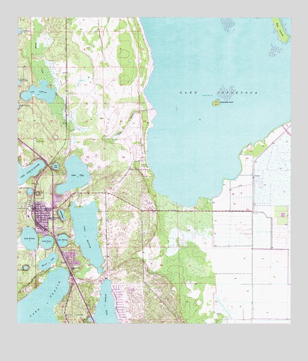
Lake Placid, FL USGS Topographic Map
Click on map above to begin viewing in our Map Viewer.

This topographic map contains these locations and features:
Feature Name Type Latitude Longitude GNIS ID View Map
American Heritage Private School of Highlands CountySchoolN27.3042°W81.3448°301557View Map
Bethel Baptist ChurchChurchN27.2979°W81.3633°2450203View Map
Big IslandIslandN27.3712°W81.2556°278696View Map
Blue LakeLakeN27.3144°W81.3575°279033View Map
Boggy BranchStreamN27.3378°W81.3120°279147View Map
Bumblebee IslandIslandN27.3403°W81.2837°279664View Map
Church of ChristChurchN27.2959°W81.3635°2450204View Map
Church of God of Placid TempleChurchN27.3174°W81.3683°2450205View Map
Church of the NazareneChurchN27.2970°W81.3740°2450206View Map
Citrus PlazaLocaleN27.3003°W81.3665°296619View Map
Compton PlazaLocaleN27.2984°W81.3673°296618View Map
Crawfords Trailer ParkPopulated PlaceN27.3231°W81.3171°2450196View Map
Faith Baptist ChurchChurchN27.2716°W81.3330°2450207View Map
Florida Highway Patrol StationBuildingN27.3198°W81.3665°2333742View Map
Florida Hospital Lake PlacidHospitalN27.3203°W81.3698°2662504View Map
Florida Hospital Lake Placid HeliportAirportN27.3202°W81.3705°2450192View Map
Grassy LakeLakeN27.2535°W81.3330°283327View Map
Hickory Grove Trailer ParkPopulated PlaceN27.3058°W81.3658°2450200View Map
Highland Parks Volunteer Fire Department Station 33BuildingN27.2998°W81.3234°2644486View Map
Highlands CountyCivilN27.3434°W81.3410°295756View Map
Highlands County Emergency Medical Services Lake PlacidBuildingN27.2956°W81.3673°2661810View Map
Highlands County Emergency Medical Services Lake Placid TomokaBuildingN27.3221°W81.3702°2661811View Map
Highlands Park EstatesPopulated PlaceN27.3037°W81.3126°300947View Map
Interlake AcademySchoolN27.2975°W81.3609°301556View Map
Lake ApthorpLakeN27.3445°W81.3643°277926View Map
Lake ClayLakeN27.3108°W81.3489°280516View Map
Lake Gardens Mobile Home ParkPopulated PlaceN27.3040°W81.3513°2450201View Map
Lake HarryLakeN27.3698°W81.3741°283775View Map
Lake HuntleyLakeN27.2873°W81.3427°284412View Map
Lake IstokpogaLakeN27.3453°W81.2542°284635View Map
Lake LaChardLakeN27.3042°W81.3690°294418View Map
Lake McCoyLakeN27.2843°W81.3541°286590View Map
Lake PearlLakeN27.2836°W81.3611°288639View Map
Lake PlacidPopulated PlaceN27.2931°W81.3629°285272View Map
Lake Placid Elementary SchoolSchoolN27.2941°W81.3697°297827View Map
Lake Placid High SchoolSchoolN27.2941°W81.3725°297828View Map
Lake Placid Middle SchoolSchoolN27.2957°W81.3728°297826View Map
Lake Placid Police DepartmentBuildingN27.2974°W81.3643°2333573View Map
Lake Placid Post OfficePost OfficeN27.3040°W81.3622°2450195View Map
Lake Placid Seventh Day Adventist ChurchChurchN27.2933°W81.3655°2449580View Map
Lake Placid Shopping CenterLocaleN27.2900°W81.3573°296617View Map
Lake Placid Volunteer Fire DepartmentBuildingN27.2971°W81.3673°2131412View Map
Lake SirenaLakeN27.2854°W81.3693°291173View Map
Lakeside Village Mobile Home ParkPopulated PlaceN27.2870°W81.3354°2450198View Map
Lost LakeLakeN27.2730°W81.3709°286107View Map
Memorial United Methodist ChurchChurchN27.3017°W81.3551°2449581View Map
Mirror LakeLakeN27.2755°W81.3606°286978View Map
New Grace Temple Church of God by FaithChurchN27.2755°W81.3503°2449582View Map
New Life Assembly ChurchChurchN27.2768°W81.3511°2449583View Map
Oak Hill CemeteryCemeteryN27.3248°W81.3667°287967View Map
Paradise Mobile VillagePopulated PlaceN27.3020°W81.3529°2450202View Map
Saddlebags LakeLakeN27.2946°W81.3544°290120View Map
Shiloh Missionary Baptist ChurchChurchN27.2790°W81.3514°2449584View Map
Sun N Lake Volunteer Fire Department Station 41BuildingN27.2517°W81.3251°2644507View Map
SunvalePopulated PlaceN27.3106°W81.2667°295657View Map
Sylvan ShoresPopulated PlaceN27.3181°W81.3412°2407604View Map
Sylvan Shores Census Designated PlaceCensusN27.3178°W81.3457°2402910View Map
Town of Lake PlacidCivilN27.2971°W81.3717°2405975View Map
Tropical Harbor Estates Mobile Home ParkPopulated PlaceN27.3189°W81.3517°2450199View Map

Note: Coordinates in the location and feature list above are referenced to NAD83 datum.


Copyright (C) 2008-2025 Ryan Niemi / Sunset Dynamics ... All Rights Reserved