TopoQuest Logo
Do you find TopoQuest useful?
Help keep TopoQuest running and adding new maps/features by donating!
Bitcoin:  19c7KJd3qBynnjoSw5npx9KScwjBe4ifkT
Litecoin:  LXs6TkuXGGXo1vDsWCkWVdjQX94eUKd6ui
Home View Maps Find Maps Find Places Resources & Links


Lake Robinson, South Carolina Topographic Map

USGS Map Title: Lake Robinson, SC
USGS Map MRC: 34080D2
DRG (GeoTIFF) Download: o34080d2.tif


Neighboring USGS Topographic Map Quads:


  Angelus, SC  
34080E3
 

  Middendorf, SC  
34080E2
 

  Patrick, SC  
34080E1
 

  Bethune, SC  
34080D3
 

  Lake Robinson, SC  
34080D2
 

  Hartsville North, SC  
34080D1
 

  Lucknow, SC  
34080C3
 

  Kellytown, SC  
34080C2
 

  Hartsville South, SC  
34080C1


Map MRC Location:

N35°
W81°
N35°
W80°
H8 H7 H6 H5 H4 H3 H2 H1
G8 G7 G6 G5 G4 G3 G2 G1
F8 F7 F6 F5 F4 F3 F2 F1
E8 E7 E6 E5 E4 E3 E2 E1
D8 D7 D6 D5 D4 D3 D2 D1
C8 C7 C6 C5 C4 C3 C2 C1
B8 B7 B6 B5 B4 B3 B2 B1
A8 A7 A6 A5 A4 A3 A2 A1
N34°
W81°
N34°
W80°

Lake Robinson, SC USGS 1:24K Topographic Map Preview:
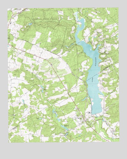
Lake Robinson, SC USGS Topographic Map
Click on map above to begin viewing in our Map Viewer.

This topographic map contains these locations and features:
Feature Name Type Latitude Longitude GNIS ID View Map
Alligator Fire Department Lake RobinsonBuildingN34.4815°W80.1470°2578251View Map
Antioch CemeteryCemeteryN34.3938°W80.1662°1240795View Map
Antioch ChurchChurchN34.3943°W80.1653°1244904View Map
Antioch School (historical)SchoolN34.3940°W80.1653°1240796View Map
Beaver Dam Mill (historical)LocaleN34.4632°W80.1484°1235588View Map
Beaverdam MillpondReservoirN34.3889°W80.1865°1245029View Map
Big Beaverdam CreekStreamN34.4657°W80.1453°1246870View Map
C P and L Slag Pond Dam D-3514DamN34.4168°W80.1615°1240045View Map
Charlie Luthers Pond Dam D-3510DamN34.4052°W80.1981°1240061View Map
Church of God of ProphecyChurchN34.4729°W80.1459°1235631View Map
ClydePopulated PlaceN34.3854°W80.1845°1221653View Map
Clyde MillpondReservoirN34.3868°W80.1831°1238460View Map
Darlington County Fire Department Pine RidgeBuildingN34.3933°W80.1673°2578240View Map
Green HillPopulated PlaceN34.4760°W80.1490°1227911View Map
Green Hill School (historical)SchoolN34.4763°W80.1487°1235668View Map
Greenhill School (historical)SchoolN34.4713°W80.1637°1235669View Map
Gum Swamp ChurchChurchN34.3827°W80.1859°1245864View Map
Hannah PondLakeN34.3972°W80.2138°1223022View Map
Harmon Pond Dam D-3201DamN34.4852°W80.2231°1239989View Map
Highway School (historical)SchoolN34.4049°W80.1695°1240889View Map
Hilton Kings Pond Dam D-3511DamN34.3952°W80.1931°1240060View Map
IngramsPopulated PlaceN34.4624°W80.2098°1235680View Map
Ington Lake Dam D-3513DamN34.3835°W80.1831°1240059View Map
Joe PondLakeN34.4725°W80.1514°1235684View Map
King MillpondReservoirN34.4235°W80.2110°1246247View Map
King Millpond Dam D-3202DamN34.4224°W80.2103°1239988View Map
Kington LakeReservoirN34.3826°W80.1842°1223743View Map
Lake RobinsonReservoirN34.4013°W80.1492°1225919View Map
Lake RobinsonReservoirN34.4404°W80.1553°1238481View Map
Lake Robinson Rescue SquadBuildingN34.3930°W80.1679°2739597View Map
Laland School (historical)SchoolN34.4438°W80.1981°1235694View Map
LelandPopulated PlaceN34.4363°W80.1728°1235693View Map
Little Beaverdam BranchStreamN34.4896°W80.1642°1246383View Map
Lower Alligator CreekStreamN34.4832°W80.1703°1224208View Map
McLean CemeteryCemeteryN34.3807°W80.2231°1224420View Map
New Hope ChurchChurchN34.4121°W80.2365°1224991View Map
New Hope School (historical)SchoolN34.4121°W80.2365°1235728View Map
New MarketPopulated PlaceN34.4015°W80.1423°1227951View Map
New Market Methodist ChurchChurchN34.4002°W80.1442°1240934View Map
Pine RidgePopulated PlaceN34.3952°W80.1628°1225469View Map
Pine Ridge ChurchChurchN34.4065°W80.1723°1250121View Map
Pine Ridge Church of GodChurchN34.3968°W80.1742°1240956View Map
Pine Ridge Congregational Holiness ChurchChurchN34.3965°W80.1634°1240957View Map
Pond Hollow BranchStreamN34.4196°W80.1423°1225599View Map
Saint Pauls CemeteryCemeteryN34.3826°W80.1953°1226241View Map
SegarsPopulated PlaceN34.3840°W80.1317°1231788View Map
Shady Grove ChurchChurchN34.4324°W80.2212°1226519View Map
South Carolina Noname 16014 D-3512 DamDamN34.3868°W80.1831°1238459View Map
South Carolina Noname 16033 DamDamN34.4013°W80.1492°1238480View Map
Sowells Pond Dam D-1832DamN34.4118°W80.2315°1239987View Map
Spring BranchStreamN34.4571°W80.1456°1226810View Map
Spring Branch ChurchChurchN34.4568°W80.1398°1250997View Map
Tabernacle (historical)Populated PlaceN34.4429°W80.1715°1235782View Map
Tabernacle ChurchChurchN34.4424°W80.1720°1251104View Map
Union CemeteryCemeteryN34.4010°W80.2431°1248746View Map
Union ChurchChurchN34.4004°W80.2431°1251259View Map

Note: Coordinates in the location and feature list above are referenced to NAD83 datum.


Copyright (C) 2008-2024 Ryan Niemi / Sunset Dynamics ... All Rights Reserved