TopoQuest Logo
Do you find TopoQuest useful?
Help keep TopoQuest running and adding new maps/features by donating!
Bitcoin:  19c7KJd3qBynnjoSw5npx9KScwjBe4ifkT
Litecoin:  LXs6TkuXGGXo1vDsWCkWVdjQX94eUKd6ui
Home View Maps Find Maps Find Places Resources & Links


Lake Shannon, Washington Topographic Map

USGS Map Title: Lake Shannon, WA
USGS Map MRC: 48121E6
DRG (GeoTIFF) Download: o48121e6.tif


Neighboring USGS Topographic Map Quads:


  Baker Pass, WA  
48121F7
 

  Welker Peak, WA  
48121F6
 

  Bacon Peak, WA  
48121F5
 

  Grandy Lake, WA  
48121E7
 

  Lake Shannon, WA  
48121E6
 

  Sauk Mountain, WA  
48121E5
 

  Gee Point, WA  
48121D7
 

  Finney Peak, WA  
48121D6
 

  Rockport, WA  
48121D5


Map MRC Location:

N49°
W122°
N49°
W121°
H8 H7 H6 H5 H4 H3 H2 H1
G8 G7 G6 G5 G4 G3 G2 G1
F8 F7 F6 F5 F4 F3 F2 F1
E8 E7 E6 E5 E4 E3 E2 E1
D8 D7 D6 D5 D4 D3 D2 D1
C8 C7 C6 C5 C4 C3 C2 C1
B8 B7 B6 B5 B4 B3 B2 B1
A8 A7 A6 A5 A4 A3 A2 A1
N48°
W122°
N48°
W121°

Lake Shannon, WA USGS 1:24K Topographic Map Preview:
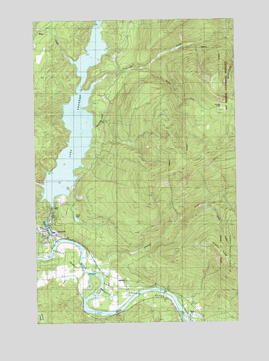
Lake Shannon, WA USGS Topographic Map
Click on map above to begin viewing in our Map Viewer.

This topographic map contains these locations and features:
Feature Name Type Latitude Longitude GNIS ID View Map
Aero - Skagit Emergency ServicesBuildingN48.5395°W121.7463°2643596View Map
Baker DamDamN48.5476°W121.7410°1516050View Map
Bear CreekStreamN48.6115°W121.7304°1516245View Map
Bear Creek DamDamN48.6198°W121.7379°1532749View Map
Bear Creek PowerhouseLocaleN48.6129°W121.7326°1533080View Map
ConcretePopulated PlaceN48.5393°W121.7463°1518004View Map
Concrete Fire DepartmentBuildingN48.5390°W121.7446°2643942View Map
Concrete Sewage Treatment PlantLocaleN48.5376°W121.7442°2610660View Map
Cooper CreekStreamN48.5054°W121.6971°1530107View Map
Everett LakeLakeN48.5429°W121.7260°1519406View Map
Faber FerryLocaleN48.5132°W121.6718°1519425View Map
Jackman CreekStreamN48.5229°W121.7179°1521302View Map
Jackman RidgeRidgeN48.5326°W121.6421°1521303View Map
Kingdom Hall of Jehovahs WitnessesChurchN48.5172°W121.6960°2609402View Map
Lake ShannonReservoirN48.5847°W121.7243°1525616View Map
MountviewLocaleN48.5048°W121.6512°1530176View Map
Nestos (historical)Populated PlaceN48.5057°W121.6999°1530571View Map
South Fork Thunder CreekStreamN48.6060°W121.6799°1526267View Map
Survey CreekStreamN48.6165°W121.6262°1526800View Map
Threemile CreekStreamN48.5809°W121.7135°1527169View Map
Thunder CreekStreamN48.5998°W121.7126°1527182View Map
Thunder LakesLakeN48.5910°W121.6340°1527189View Map
Upper Skagit Garden Club ParkParkN48.5407°W121.7454°1530445View Map
Upper Skagit LibraryBuildingN48.5387°W121.7492°2610216View Map
Van HornPopulated PlaceN48.5165°W121.7054°1527669View Map
Weber CreekStreamN48.5490°W121.6457°1527870View Map

Note: Coordinates in the location and feature list above are referenced to NAD83 datum.


Copyright (C) 2008-2024 Ryan Niemi / Sunset Dynamics ... All Rights Reserved