TopoQuest Logo
Do you find TopoQuest useful?
Help keep TopoQuest running and adding new maps/features by donating!
Bitcoin:  19c7KJd3qBynnjoSw5npx9KScwjBe4ifkT
Litecoin:  LXs6TkuXGGXo1vDsWCkWVdjQX94eUKd6ui
Home View Maps Find Maps Find Places Resources & Links


Lake Sweetwater, Texas Topographic Map

USGS Map Title: Lake Sweetwater, TX
USGS Map MRC: 32100D3
DRG (GeoTIFF) Download: o32100d3.tif


Neighboring USGS Topographic Map Quads:


  Busby, TX  
32100E4
 

  Eskota, TX  
32100E3
 

  Raven Creek South, TX  
32100E2
 

  Sweetwater, TX  
32100D4
 

  Lake Sweetwater, TX  
32100D3
 

  Chalk Peak, TX  
32100D2
 

  Lake Trammell, TX  
32100C4
 

  Holder Creek, TX  
32100C3
 

  Nolan, TX  
32100C2


Map MRC Location:

N33°
W101°
N33°
W100°
H8 H7 H6 H5 H4 H3 H2 H1
G8 G7 G6 G5 G4 G3 G2 G1
F8 F7 F6 F5 F4 F3 F2 F1
E8 E7 E6 E5 E4 E3 E2 E1
D8 D7 D6 D5 D4 D3 D2 D1
C8 C7 C6 C5 C4 C3 C2 C1
B8 B7 B6 B5 B4 B3 B2 B1
A8 A7 A6 A5 A4 A3 A2 A1
N32°
W101°
N32°
W100°

Lake Sweetwater, TX USGS 1:24K Topographic Map Preview:
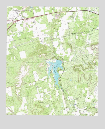
Lake Sweetwater, TX USGS Topographic Map
Click on map above to begin viewing in our Map Viewer.

This topographic map contains these locations and features:
Feature Name Type Latitude Longitude GNIS ID View Map
Beacon HillSummitN32.4554°W100.2882°1330185View Map
Blue Gainey PointCliffN32.4454°W100.2543°1330902View Map
Boothe LakeReservoirN32.3768°W100.3470°1865499View Map
Boothe Lake DamDamN32.3768°W100.3470°1865498View Map
Coffee CemeteryCemeteryN32.4360°W100.2984°1333056View Map
Cottonwood CreekStreamN32.4232°W100.3159°1333469View Map
Cottonwood MountainSummitN32.3893°W100.3293°1333485View Map
Dug SpringSpringN32.4346°W100.2559°1334734View Map
Dug Spring CanyonValleyN32.4449°W100.2712°1334735View Map
Firemans PointCapeN32.4321°W100.3115°1335808View Map
Garden of memories CemeteryCemeteryN32.4857°W100.3548°1336391View Map
Gesin Ranches AirportAirportN32.4031°W100.3717°1387611View Map
Holder CreekStreamN32.3771°W100.2740°1337926View Map
Kildoogan CreekStreamN32.4937°W100.3518°1374371View Map
Lake SweetwaterReservoirN32.4273°W100.3084°1348148View Map
Lake Sweetwater DamDamN32.4385°W100.3020°1859641View Map
Lake Sweetwater Municipal ParkParkN32.4318°W100.2920°2028984View Map
Lake Sweetwater Volunteer Fire DepartmentBuildingN32.4426°W100.3059°2551385View Map
Oaties HollowValleyN32.3801°W100.2751°1343049View Map
Outlaw CanyonValleyN32.4449°W100.2713°1343359View Map
Rafter P AirportAirportN32.3827°W100.2766°2675929View Map
Sweetwater DivisionCivilN32.4491°W100.3152°1939244View Map
Sweetwater ParkParkN32.4243°W100.3093°1348146View Map
Town CreekStreamN32.4621°W100.3701°1348683View Map

Note: Coordinates in the location and feature list above are referenced to NAD83 datum.


Copyright (C) 2008-2025 Ryan Niemi / Sunset Dynamics ... All Rights Reserved