TopoQuest Logo
Do you find TopoQuest useful?
Help keep TopoQuest running and adding new maps/features by donating!
Bitcoin:  19c7KJd3qBynnjoSw5npx9KScwjBe4ifkT
Litecoin:  LXs6TkuXGGXo1vDsWCkWVdjQX94eUKd6ui
Home View Maps Find Maps Find Places Resources & Links


Lake Valley, Oklahoma Topographic Map

USGS Map Title: Lake Valley, OK
USGS Map MRC: 35098B7
DRG (GeoTIFF) Download: o35098b7.tif


Neighboring USGS Topographic Map Quads:


  Cordell, OK  
35098C8
 

  Cloud Chief, OK  
35098C7
 

  Colony, OK  
35098C6
 

  Gotebo NW, OK  
35098B8
 

  Lake Valley, OK  
35098B7
 

  Cowden, OK  
35098B6
 

  Gotebo West, OK  
35098A8
 

  Gotebo East, OK  
35098A7
 

  Stinking Creek, OK  
35098A6


Map MRC Location:

N36°
W99°
N36°
W98°
H8 H7 H6 H5 H4 H3 H2 H1
G8 G7 G6 G5 G4 G3 G2 G1
F8 F7 F6 F5 F4 F3 F2 F1
E8 E7 E6 E5 E4 E3 E2 E1
D8 D7 D6 D5 D4 D3 D2 D1
C8 C7 C6 C5 C4 C3 C2 C1
B8 B7 B6 B5 B4 B3 B2 B1
A8 A7 A6 A5 A4 A3 A2 A1
N35°
W99°
N35°
W98°

Lake Valley, OK USGS 1:24K Topographic Map Preview:
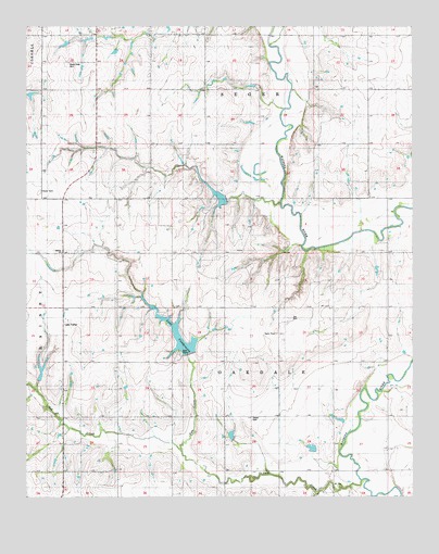
Lake Valley, OK USGS Topographic Map
Click on map above to begin viewing in our Map Viewer.

This topographic map contains these locations and features:
Feature Name Type Latitude Longitude GNIS ID View Map
Cloud Chief CemeteryCemeteryN35.2399°W98.8619°1091476View Map
Fesser CemeteryCemeteryN35.1463°W98.8023°1092797View Map
Gyp CreekStreamN35.1367°W98.8253°1093456View Map
Indian Village (historical)Populated PlaceN35.1959°W98.8116°2461030View Map
Lake ValleyPopulated PlaceN35.1681°W98.8631°1100561View Map
Lake VanderworkLakeN35.1681°W98.8264°1777569View Map
Oak CreekStreamN35.1298°W98.7665°1096082View Map
Oak Creek Site 4 DamDamN35.1551°W98.8720°1756685View Map
Oak Creek Site 4 ReservoirReservoirN35.1551°W98.8720°1756686View Map
Oak Creek Site 5 DamDamN35.1617°W98.8237°1756687View Map
Oak Creek Site 5 ReservoirReservoirN35.1681°W98.8264°1756688View Map
Oak Creek Site 7 DamDamN35.1401°W98.8087°1756689View Map
Oak Creek Site 7 ReservoirReservoirN35.1415°W98.8091°1756690View Map
Oak Creek Site 8 DamDamN35.1367°W98.7837°1756691View Map
Oak Creek Site 8 ReservoirReservoirN35.1381°W98.7831°1756692View Map
Oak Creek Site 9 DamDamN35.2034°W98.8087°1756693View Map
Oak Creek Site 9 ReservoirReservoirN35.2034°W98.8087°1756694View Map
Oknoname 149007 DamDamN35.1834°W98.7620°1755954View Map
Oknoname 149007 ReservoirReservoirN35.1844°W98.7619°1755955View Map
Sharon CemeteryCemeteryN35.1894°W98.8639°2706763View Map
Sharon ChurchChurchN35.1898°W98.8631°1097957View Map
Southeast Washita DivisionCivilN35.1950°W98.7564°1937860View Map

Note: Coordinates in the location and feature list above are referenced to NAD83 datum.


Copyright (C) 2008-2025 Ryan Niemi / Sunset Dynamics ... All Rights Reserved