TopoQuest Logo
Do you find TopoQuest useful?
Help keep TopoQuest running and adding new maps/features by donating!
Bitcoin:  19c7KJd3qBynnjoSw5npx9KScwjBe4ifkT
Litecoin:  LXs6TkuXGGXo1vDsWCkWVdjQX94eUKd6ui
Home View Maps Find Maps Find Places Resources & Links


Las Animas, Colorado Topographic Map

USGS Map Title: Las Animas, CO
USGS Map MRC: 38103A2
DRG (GeoTIFF) Download: o38103a2.tif


Neighboring USGS Topographic Map Quads:


  McIntosh Ranch, CO  
38103B3
 

  Bishop Ranch, CO  
38103B2
 

  Tree Top Ranch, CO  
38103B1
 

  Cornelia, CO  
38103A3
 

  Las Animas, CO  
38103A2
 

  Kreybill, CO  
38103A1
 

  Hackamore Ranch, CO  
37103H3
 

  Gilpin, CO  
37103H2
 

  Toonerville NE, CO  
37103H1


Map MRC Location:

N39°
W104°
N39°
W103°
H8 H7 H6 H5 H4 H3 H2 H1
G8 G7 G6 G5 G4 G3 G2 G1
F8 F7 F6 F5 F4 F3 F2 F1
E8 E7 E6 E5 E4 E3 E2 E1
D8 D7 D6 D5 D4 D3 D2 D1
C8 C7 C6 C5 C4 C3 C2 C1
B8 B7 B6 B5 B4 B3 B2 B1
A8 A7 A6 A5 A4 A3 A2 A1
N38°
W104°
N38°
W103°

Las Animas, CO USGS 1:24K Topographic Map Preview:
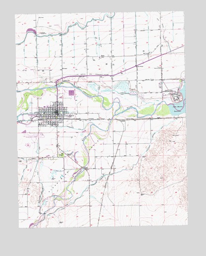
Las Animas, CO USGS Topographic Map
Click on map above to begin viewing in our Map Viewer.

This topographic map contains these locations and features:
Feature Name Type Latitude Longitude GNIS ID View Map
Bent County AmbulanceBuildingN38.0710°W103.2269°2716962View Map
Bent County Correctional FacilityBuildingN38.0651°W103.2056°2757327View Map
Bent County Public Health OfficeBuildingN38.0652°W103.2380°2695598View Map
Bent County Sheriff's OfficeBuildingN38.0789°W103.2183°2696629View Map
BoggsvillePopulated PlaceN38.0417°W103.2127°195528View Map
Church of ChristChurchN38.0707°W103.2177°2696415View Map
Church of the NazareneChurchN38.0652°W103.2184°2696410View Map
City of Las AnimasCivilN38.0695°W103.2235°2411628View Map
City of Las Animas - Bent County AirportAirportN38.0540°W103.2374°195527View Map
Consolidated Extension DitchCanalN38.0333°W103.1672°195534View Map
First Baptist ChurchChurchN38.0666°W103.2242°2696406View Map
First Presbyterian Church of Las AnimasChurchN38.0661°W103.2263°2696407View Map
First United Methodist Church of Las AnimasChurchN38.0667°W103.2236°2696405View Map
Fort LyonPopulated PlaceN38.0922°W103.1522°204828View Map
Fort Lyon National CemeteryCemeteryN38.0847°W103.1294°195525View Map
Fort Lyon Veterans Hospital (historical)HospitalN38.0764°W103.1324°195533View Map
Friends ChurchChurchN38.0687°W103.2216°2696414View Map
John Donlon DrawValleyN38.1072°W103.1379°195523View Map
KellerPopulated PlaceN38.0628°W103.1463°195532View Map
Keller SchoolSchoolN38.0408°W103.1791°195531View Map
Las AnimasPopulated PlaceN38.0667°W103.2227°195526View Map
Las Animas CemeteryCemeteryN38.0425°W103.2180°195529View Map
Las Animas Country ClubLocaleN38.1139°W103.2316°195519View Map
Las Animas Family PracticeBuildingN38.0701°W103.2210°2695620View Map
Las Animas Fire DepartmentBuildingN38.0673°W103.2221°2666838View Map
Las Animas JunctionPopulated PlaceN38.0625°W103.1741°195530View Map
Las Animas Police DepartmentBuildingN38.0678°W103.2208°2696623View Map
Las Animas Post OfficePost OfficeN38.0661°W103.2230°2750880View Map
McCauley DitchCanalN38.1053°W103.1372°195524View Map
MelinaPopulated PlaceN38.0995°W103.1866°195521View Map
Nelson ParkParkN38.0639°W103.2366°195518View Map
Old Santa Fe TrailTrailN38.0889°W103.1922°169599View Map
Parkview Baptist ChurchChurchN38.0661°W103.2379°2696409View Map
Picketwire ValleyValleyN38.0670°W103.1755°195660View Map
Purgatoire RiverStreamN38.0650°W103.1769°201784View Map
Rixey SchoolSchoolN38.0931°W103.1613°195522View Map
Saint Marys Catholic ChurchChurchN38.0652°W103.2223°2696408View Map
Saint Paul Lutheran ChurchChurchN38.0648°W103.2309°2696413View Map
Seed and Supply ChurchChurchN38.0640°W103.2304°2696416View Map

Note: Coordinates in the location and feature list above are referenced to NAD83 datum.


Copyright (C) 2008-2025 Ryan Niemi / Sunset Dynamics ... All Rights Reserved