TopoQuest Logo
Do you find TopoQuest useful?
Help keep TopoQuest running and adding new maps/features by donating!
Bitcoin:  19c7KJd3qBynnjoSw5npx9KScwjBe4ifkT
Litecoin:  LXs6TkuXGGXo1vDsWCkWVdjQX94eUKd6ui
Home View Maps Find Maps Find Places Resources & Links


Las Milpas, Texas Topographic Map

USGS Map Title: Las Milpas, TX
USGS Map MRC: 26098A2
DRG (GeoTIFF) Download: o26098a2.tif


Neighboring USGS Topographic Map Quads:


  Mission, TX  
26098B3
 

  Pharr, TX  
26098B2
 

  Donna, TX  
26098B1
 

  Hidalgo, TX  
26098A3
 

  Las Milpas, TX  
26098A2
 

  San Juan SE, TX  
26098A1


Map MRC Location:

N27°
W99°
N27°
W98°
H8 H7 H6 H5 H4 H3 H2 H1
G8 G7 G6 G5 G4 G3 G2 G1
F8 F7 F6 F5 F4 F3 F2 F1
E8 E7 E6 E5 E4 E3 E2 E1
D8 D7 D6 D5 D4 D3 D2 D1
C8 C7 C6 C5 C4 C3 C2 C1
B8 B7 B6 B5 B4 B3 B2 B1
A8 A7 A6 A5 A4 A3 A2 A1
N26°
W99°
N26°
W98°

Las Milpas, TX USGS 1:24K Topographic Map Preview:
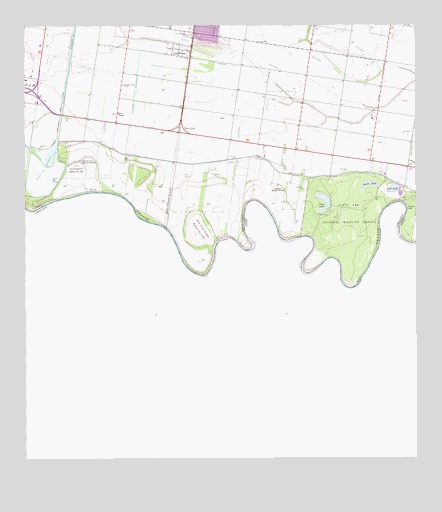
Las Milpas, TX USGS Topographic Map
Click on map above to begin viewing in our Map Viewer.

This topographic map contains these locations and features:
Feature Name Type Latitude Longitude GNIS ID View Map
Beto's Acres ColoniaPopulated PlaceN26.1165°W98.1992°2009879View Map
Brewster CemeteryCemeteryN26.0781°W98.1606°1331236View Map
Capota CemeteryCemeteryN26.0820°W98.1964°1332133View Map
Carlson LakeReservoirN26.0819°W98.2444°1861701View Map
Carlson Lake LeveeDamN26.0887°W98.2403°1861700View Map
City of HidalgoCivilN26.1080°W98.2479°2410755View Map
Diaz Junior High SchoolSchoolN26.0977°W98.2491°2006499View Map
Don Juan Cross Banco Number 155LeveeN26.0662°W98.1933°1334477View Map
East LakeLakeN26.0781°W98.1325°1334959View Map
Ed Vela Gas FieldOilfieldN26.0815°W98.2303°1335078View Map
Fays CornerPopulated PlaceN26.0942°W98.1997°1378287View Map
H and B ColoniaPopulated PlaceN26.1223°W98.1972°2011197View Map
Hidalgo Park Estates ColoniaPopulated PlaceN26.1223°W98.1903°2011212View Map
Ida Diaz Elementary SchoolSchoolN26.0976°W98.2492°1987945View Map
IDEA Academy PharrSchoolN26.1171°W98.2071°2652166View Map
IDEA College Preparatory PharrSchoolN26.1169°W98.2066°2652167View Map
Inland LakeLakeN26.0723°W98.1258°1338479View Map
Jackson CemeteryCemeteryN26.0865°W98.1814°1338575View Map
Jalisco Banco Number 67LeveeN26.0784°W98.1683°1338620View Map
Kelley Elementary SchoolSchoolN26.1167°W98.1945°1987947View Map
Kelly Elementary SchoolSchoolN26.1160°W98.1942°2006479View Map
Klump Gas FieldOilfieldN26.0717°W98.1928°1339180View Map
La Chapena Banco Number 99LeveeN26.0840°W98.2333°1339293View Map
Las Brisas del Sur ColoniaPopulated PlaceN26.1165°W98.2022°2011132View Map
Las Fuentes ColoniaPopulated PlaceN26.1142°W98.2022°2011085View Map
Las Haciendas ColoniaPopulated PlaceN26.1142°W98.1953°2011086View Map
Las MilpasPopulated PlaceN26.1184°W98.1995°1339670View Map
Las Palomas Wildlife Management Area - Kelly UnitParkN26.0770°W98.1939°2028966View Map
Los Ranchitos Number 1-3 ColoniaPopulated PlaceN26.1234°W98.2064°2011103View Map
Los Torritos Gas FieldOilfieldN26.0731°W98.1653°1340632View Map
Los Torritos North Gas FieldOilfieldN26.1051°W98.1672°1340633View Map
Lower Rio Grande Valley National Wildlife Refuge TrailTrailN26.0881°W98.2303°2033418View Map
Mercy MissionChurchN26.0998°W98.2195°1341376View Map
North LakeLakeN26.0795°W98.1395°1342765View Map
Old CemeteryCemeteryN26.0642°W98.1414°1343125View Map
Palo Verde ColoniaPopulated PlaceN26.1234°W98.1992°2011002View Map
Pharr Memorial CemeteryCemeteryN26.1226°W98.1958°1343932View Map
Sanchez Ranch ColoniaPopulated PlaceN26.0965°W98.2253°2010883View Map
Santa Ana National Wildlife RefugeParkN26.0694°W98.1462°1346615View Map
Santa Ana National Wildlife Refuge TrailTrailN26.0676°W98.1481°2033192View Map
Santa Cruz Banco Number 43LeveeN26.0862°W98.2292°1346630View Map
Southfork Estates ColoniaPopulated PlaceN26.0965°W98.1853°2010630View Map
Valle Alto Number 1 ColoniaPopulated PlaceN26.1042°W98.2322°2011543View Map
Valle Alto Number 2 ColoniaPopulated PlaceN26.1015°W98.2322°2011544View Map
Valley View Elementary SchoolSchoolN26.1122°W98.2129°2006418View Map
Valley View Fifth Grade SchoolSchoolN26.1039°W98.2223°2681054View Map
Valley View High SchoolSchoolN26.1032°W98.2214°1987946View Map
Valley View Independent School District HeadquartersSchoolN26.1041°W98.2222°2681055View Map
Valley View Junior High SchoolSchoolN26.1085°W98.2179°1349180View Map
Valley View North Elementary SchoolSchoolN26.1120°W98.2129°2006432View Map
Valley View South Elementary SchoolSchoolN26.1077°W98.2289°2681051View Map
Valley View Wilbur E. Lucas SchoolSchoolN26.1119°W98.2296°2681052View Map
Villas del Valle ColoniaPopulated PlaceN26.1242°W98.1864°2011562View Map
West LakeLakeN26.0729°W98.1539°1349754View Map

Note: Coordinates in the location and feature list above are referenced to NAD83 datum.


Copyright (C) 2008-2024 Ryan Niemi / Sunset Dynamics ... All Rights Reserved