TopoQuest Logo
Do you find TopoQuest useful?
Help keep TopoQuest running and adding new maps/features by donating!
Bitcoin:  19c7KJd3qBynnjoSw5npx9KScwjBe4ifkT
Litecoin:  LXs6TkuXGGXo1vDsWCkWVdjQX94eUKd6ui
Home View Maps Find Maps Find Places Resources & Links


Laurel, Florida Topographic Map

USGS Map Title: Laurel, FL
USGS Map MRC: 27082B4
DRG (GeoTIFF) Download: o27082b4.tif


Neighboring USGS Topographic Map Quads:


  Sarasota, FL  
27082C5
 

  Bee Ridge, FL  
27082C4
 

  Old Myakka, FL  
27082C3
 

  Bird Keys, FL  
27082B5
 

  Laurel, FL  
27082B4
 

  Lower Myakka Lake, FL  
27082B3


  Venice, FL  
27082A4
 

  Myakka River, FL  
27082A3


Map MRC Location:

N28°
W83°
N28°
W82°
H8 H7 H6 H5 H4 H3 H2 H1
G8 G7 G6 G5 G4 G3 G2 G1
F8 F7 F6 F5 F4 F3 F2 F1
E8 E7 E6 E5 E4 E3 E2 E1
D8 D7 D6 D5 D4 D3 D2 D1
C8 C7 C6 C5 C4 C3 C2 C1
B8 B7 B6 B5 B4 B3 B2 B1
A8 A7 A6 A5 A4 A3 A2 A1
N27°
W83°
N27°
W82°

Laurel, FL USGS 1:24K Topographic Map Preview:
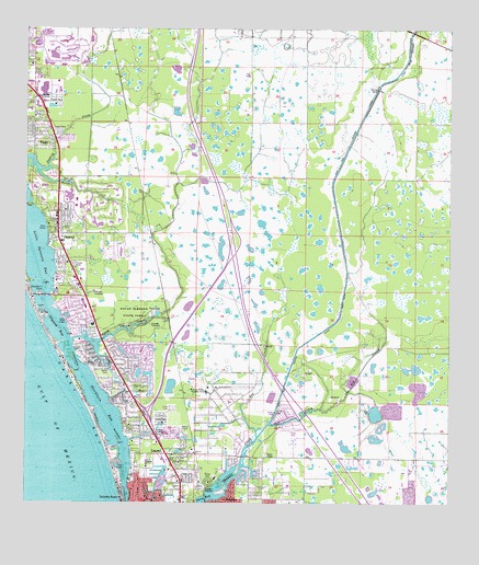
Laurel, FL USGS Topographic Map
Click on map above to begin viewing in our Map Viewer.

This topographic map contains these locations and features:
Feature Name Type Latitude Longitude GNIS ID View Map
Blackburn BayBayN27.1466°W82.4760°278945View Map
Blackburn PointCapeN27.1801°W82.4954°278949View Map
Casey KeyIslandN27.1501°W82.4807°280108View Map
Cow Pen SloughStreamN27.1503°W82.4131°280940View Map
Cow Pen Slough CanalCanalN27.2245°W82.4012°280941View Map
Dryman BayBayN27.1705°W82.4876°281805View Map
Fox CreekStreamN27.1428°W82.4312°282761View Map
Knight LakeLakeN27.1484°W82.3970°2090301View Map
LaurelPopulated PlaceN27.1303°W82.4532°285395View Map
Laurel Census Designated PlaceCensusN27.1447°W82.4618°2403223View Map
Laurel Post OfficePost OfficeN27.1382°W82.4534°2768212View Map
Laurel VillaPopulated PlaceN27.1503°W82.4562°300864View Map
Mission Valley Country ClubLocaleN27.1551°W82.4459°286991View Map
Nokomis BeachPopulated PlaceN27.1264°W82.4709°287755View Map
Nokomis ChurchChurchN27.1345°W82.4634°287756View Map
Nokomis Fire Department Station 42BuildingN27.1524°W82.4660°2644559View Map
Nokomis Post OfficePost OfficeN27.1377°W82.4610°2768168View Map
North CreekStreamN27.2128°W82.4970°287799View Map
Oaks HelistopAirportN27.2067°W82.4879°309943View Map
Oscar Scherer State ParkParkN27.1751°W82.4662°288260View Map
OspreyPopulated PlaceN27.1962°W82.4904°288268View Map
Osprey Census Designated PlaceCensusN27.1915°W82.4800°2403382View Map
Osprey Post OfficePost OfficeN27.1912°W82.4868°2768158View Map
Salt CreekStreamN27.1459°W82.4273°290422View Map
Sarasota County Fire Department Station 14BuildingN27.2217°W82.4910°2131590View Map
Sarasota County Fire Department Station 15BuildingN27.2176°W82.4604°2644508View Map
Sarasota County Fire Department Station 23BuildingN27.1525°W82.4660°2131595View Map
Sarasota County Rescue Station 53BuildingN27.1369°W82.3769°2661757View Map
Sarasota County Sheriff's Office Community Policing StationBuildingN27.2348°W82.4940°2333790View Map
Sarasota County SSarasota County Sheriff's OfficeBuildingN27.1315°W82.4548°2333601View Map
Sarasota National CemeteryCemeteryN27.2451°W82.3787°2498898View Map
Shakett CreekStreamN27.1281°W82.4437°290913View Map
South CreekStreamN27.1678°W82.4865°291364View Map
VamoPopulated PlaceN27.2220°W82.4979°292728View Map
Vamo Census Designated PlaceCensusN27.2254°W82.4944°2402960View Map
Venice Fire Department Station 53BuildingN27.1368°W82.3752°2644645View Map
WJIS-FM (Bradenton)TowerN27.1320°W82.3940°308960View Map

Note: Coordinates in the location and feature list above are referenced to NAD83 datum.


Copyright (C) 2008-2024 Ryan Niemi / Sunset Dynamics ... All Rights Reserved