TopoQuest Logo
Do you find TopoQuest useful?
Help keep TopoQuest running and adding new maps/features by donating!
Bitcoin:  19c7KJd3qBynnjoSw5npx9KScwjBe4ifkT
Litecoin:  LXs6TkuXGGXo1vDsWCkWVdjQX94eUKd6ui
Home View Maps Find Maps Find Places Resources & Links


Lebam, Washington Topographic Map

USGS Map Title: Lebam, WA
USGS Map MRC: 46123E5
DRG (GeoTIFF) Download: o46123e5.tif


Neighboring USGS Topographic Map Quads:


  Raymond, WA  
46123F6
 

  East of Raymond, WA  
46123F5
 

  Dean Creek, WA  
46123F4
 

  Menlo, WA  
46123E6
 

  Lebam, WA  
46123E5
 

  Pluvius, WA  
46123E4
 

  Upper Naselle River, WA  
46123D6
 

  Sweigiler Creek, WA  
46123D5
 

  Blaney Creek, WA  
46123D4


Map MRC Location:

N47°
W124°
N47°
W123°
H8 H7 H6 H5 H4 H3 H2 H1
G8 G7 G6 G5 G4 G3 G2 G1
F8 F7 F6 F5 F4 F3 F2 F1
E8 E7 E6 E5 E4 E3 E2 E1
D8 D7 D6 D5 D4 D3 D2 D1
C8 C7 C6 C5 C4 C3 C2 C1
B8 B7 B6 B5 B4 B3 B2 B1
A8 A7 A6 A5 A4 A3 A2 A1
N46°
W124°
N46°
W123°

Lebam, WA USGS 1:24K Topographic Map Preview:
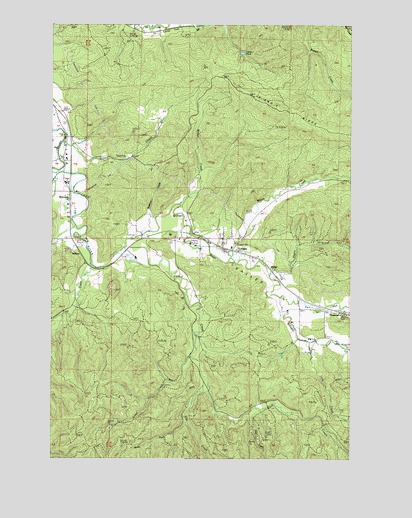
Lebam, WA USGS Topographic Map
Click on map above to begin viewing in our Map Viewer.

This topographic map contains these locations and features:
Feature Name Type Latitude Longitude GNIS ID View Map
Camp Seven PondReservoirN46.6167°W123.5470°1513963View Map
Camp Seven Pond Number Two DamDamN46.6165°W123.5479°1532900View Map
Elk PrairieFlatN46.5320°W123.5002°1504718View Map
Ellis CreekStreamN46.5193°W123.5607°1504735View Map
Falls CreekStreamN46.5334°W123.5188°1504824View Map
Fern CreekStreamN46.5465°W123.5310°1504850View Map
FirdalePopulated PlaceN46.6240°W123.5724°1510967View Map
Fork CreekStreamN46.5584°W123.5982°1504964View Map
Forks Creek BridgeBridgeN46.5583°W123.5968°2608003View Map
Forks Creek HatcheryLocaleN46.5581°W123.5949°2605546View Map
FrancesPopulated PlaceN46.5423°W123.5049°1512226View Map
GlobePopulated PlaceN46.5551°W123.5363°1510996View Map
Green CreekStreamN46.5912°W123.6202°1505261View Map
Half Moon CreekStreamN46.5582°W123.5513°1505343View Map
HolcombPopulated PlaceN46.5720°W123.6174°1511037View Map
LebamPopulated PlaceN46.5590°W123.5490°1512384View Map
Lebam Census Designated PlaceCensusN46.5641°W123.5509°2408594View Map
Lebam Community ChurchChurchN46.5604°W123.5547°2609596View Map
Lebam Elementary SchoolSchoolN46.5620°W123.5602°1515073View Map
Lebam Post OfficePost OfficeN46.5613°W123.5579°2606965View Map
NallpeePopulated PlaceN46.5582°W123.6124°1511174View Map
Noe CreekStreamN46.5132°W123.5449°1507004View Map
P and E RidgeRidgeN46.6009°W123.5318°1502912View Map
Pacific County Fire District 3 LebamBuildingN46.5602°W123.5535°2619871View Map
Penny CreekStreamN46.5526°W123.5357°1502914View Map
Robinson CreekStreamN46.5657°W123.5852°1507832View Map
Sienko DamDamN46.5898°W123.6163°1532645View Map
Silver CreekStreamN46.5293°W123.5679°1508336View Map
Talbot DamDamN46.5982°W123.5813°1532897View Map
Trap CreekStreamN46.5559°W123.6093°1509073View Map
Trap Creek BridgeBridgeN46.5557°W123.6114°2608004View Map
Walker CreekStreamN46.5732°W123.5724°1509260View Map
West Fork Ellis CreekStreamN46.5115°W123.5707°1509394View Map
Willapa Valley DivisionCivilN46.6016°W123.5350°1939675View Map

Note: Coordinates in the location and feature list above are referenced to NAD83 datum.


Copyright (C) 2008-2025 Ryan Niemi / Sunset Dynamics ... All Rights Reserved