TopoQuest Logo
Do you find TopoQuest useful?
Help keep TopoQuest running and adding new maps/features by donating!
Bitcoin:  19c7KJd3qBynnjoSw5npx9KScwjBe4ifkT
Litecoin:  LXs6TkuXGGXo1vDsWCkWVdjQX94eUKd6ui
Home View Maps Find Maps Find Places Resources & Links


Leesville, Missouri Topographic Map

USGS Map Title: Leesville, MO
USGS Map MRC: 38093C5
DRG (GeoTIFF) Download: o38093c5.tif


Neighboring USGS Topographic Map Quads:


  Calhoun West, MO  
38093D6
 

  Calhoun East, MO  
38093D5
 

  Lincoln NW, MO  
38093D4
 

  Gaines, MO  
38093C6
 

  Leesville, MO  
38093C5
 

  Shawnee Bend, MO  
38093C4
 

  Lowry City, MO  
38093B6
 

  Ninnescah Park, MO  
38093B5
 

  Warsaw West, MO  
38093B4


Map MRC Location:

N39°
W94°
N39°
W93°
H8 H7 H6 H5 H4 H3 H2 H1
G8 G7 G6 G5 G4 G3 G2 G1
F8 F7 F6 F5 F4 F3 F2 F1
E8 E7 E6 E5 E4 E3 E2 E1
D8 D7 D6 D5 D4 D3 D2 D1
C8 C7 C6 C5 C4 C3 C2 C1
B8 B7 B6 B5 B4 B3 B2 B1
A8 A7 A6 A5 A4 A3 A2 A1
N38°
W94°
N38°
W93°

Leesville, MO USGS 1:24K Topographic Map Preview:
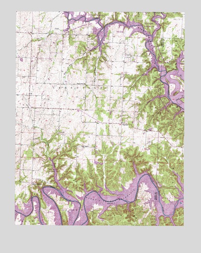
Leesville, MO USGS Topographic Map
Click on map above to begin viewing in our Map Viewer.

This topographic map contains these locations and features:
Feature Name Type Latitude Longitude GNIS ID View Map
Barker CreekStreamN38.3739°W93.5869°713646View Map
Brush CreekStreamN38.3606°W93.5244°714863View Map
Cedar CreekStreamN38.2675°W93.5899°715581View Map
Clear CreekStreamN38.3200°W93.5044°715932View Map
CoalPopulated PlaceN38.3259°W93.6152°729720View Map
Coal School (historical)SchoolN38.3238°W93.6156°745051View Map
Fargo School (historical)SchoolN38.2714°W93.5024°717847View Map
HortensePopulated PlaceN38.3622°W93.5960°740265View Map
Hortense Post Office (historical)Post OfficeN38.3622°W93.5960°745062View Map
Hortense School (historical)SchoolN38.3617°W93.5991°719878View Map
Lawler School (historical)SchoolN38.3616°W93.5991°745071View Map
LeesvillePopulated PlaceN38.3486°W93.5447°729764View Map
Leesville Elementary SchoolSchoolN38.3201°W93.6063°2743847View Map
Leesville School (historical)SchoolN38.3503°W93.5438°745072View Map
Leesville State Wildlife Management AreaParkN38.3192°W93.5108°743207View Map
Logan School (historical)SchoolN38.3100°W93.5469°745475View Map
Mirror Lake Number 1 DamDamN38.2750°W93.5185°765464View Map
Mirror Lake Number 2 DamDamN38.2734°W93.5152°764042View Map
Mound Springs CreekStreamN38.3556°W93.5644°722699View Map
Mound Springs School (historical)SchoolN38.2745°W93.6119°722700View Map
Norfleet Lake DamDamN38.2984°W93.5535°763550View Map
Number 135 ReservoirReservoirN38.2734°W93.5152°764043View Map
Parks ChapelChurchN38.2961°W93.5716°724043View Map
Parks Chapel CemeteryCemeteryN38.2971°W93.5708°2702282View Map
Plumlee Lake DamDamN38.2884°W93.6102°763549View Map
Shady Grove School (historical)SchoolN38.3325°W93.5738°726248View Map
Sparrow CreekStreamN38.3703°W93.5869°726832View Map
Tebo ChurchChurchN38.3559°W93.5633°727510View Map
Tebo Church CemeteryCemeteryN38.3539°W93.5458°2702283View Map
Tebo Islands State Wildlife Management AreaParkN38.3345°W93.5022°743208View Map
TightwadPopulated PlaceN38.3095°W93.5466°741321View Map
Tightwad Fire Protection DistrictBuildingN38.3100°W93.5452°2621554View Map
Township of LeesvilleCivilN38.3189°W93.5752°766744View Map
Turner School (historical)SchoolN38.3037°W93.5928°727905View Map
Village of TightwadCivilN38.3096°W93.5466°2399980View Map
Western OzarksAreaN38.2503°W93.5005°758122View Map
White Oak CreekStreamN38.3525°W93.5706°728746View Map
Windsor Crossing Public Use AreaParkN38.3645°W93.5452°742911View Map

Note: Coordinates in the location and feature list above are referenced to NAD83 datum.


Copyright (C) 2008-2025 Ryan Niemi / Sunset Dynamics ... All Rights Reserved