TopoQuest Logo
Do you find TopoQuest useful?
Help keep TopoQuest running and adding new maps/features by donating!
Bitcoin:  19c7KJd3qBynnjoSw5npx9KScwjBe4ifkT
Litecoin:  LXs6TkuXGGXo1vDsWCkWVdjQX94eUKd6ui
Home View Maps Find Maps Find Places Resources & Links


Lewistown, Illinois Topographic Map

USGS Map Title: Lewistown, IL
USGS Map MRC: 40090D2
DRG (GeoTIFF) Download: o40090d2.tif


Neighboring USGS Topographic Map Quads:


  Blyton, IL  
40090E3
 

  Fiatt, IL  
40090E2
 

  Canton, IL  
40090E1
 

  Smithfield, IL  
40090D3
 

  Lewistown, IL  
40090D2
 

  Saint David, IL  
40090D1
 

  Ipava, IL  
40090C3
 

  Duncan Mills, IL  
40090C2
 

  Havana, IL  
40090C1


Map MRC Location:

N41°
W91°
N41°
W90°
H8 H7 H6 H5 H4 H3 H2 H1
G8 G7 G6 G5 G4 G3 G2 G1
F8 F7 F6 F5 F4 F3 F2 F1
E8 E7 E6 E5 E4 E3 E2 E1
D8 D7 D6 D5 D4 D3 D2 D1
C8 C7 C6 C5 C4 C3 C2 C1
B8 B7 B6 B5 B4 B3 B2 B1
A8 A7 A6 A5 A4 A3 A2 A1
N40°
W91°
N40°
W90°

Lewistown, IL USGS 1:24K Topographic Map Preview:
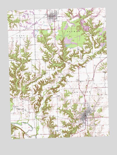
Lewistown, IL USGS Topographic Map
Click on map above to begin viewing in our Map Viewer.

This topographic map contains these locations and features:
Feature Name Type Latitude Longitude GNIS ID View Map
Antioch School (historical)SchoolN40.4373°W90.1282°424173View Map
Big CreekStreamN40.3773°W90.2190°424174View Map
Bishop School (historical)SchoolN40.4603°W90.1626°424175View Map
Carthage Lake Number 1ReservoirN40.4300°W90.1518°1691244View Map
Carthage Lake Number 1 DamDamN40.4300°W90.1518°1691243View Map
City of CubaCivilN40.4936°W90.1934°2393689View Map
City of LewistownCivilN40.3969°W90.1555°2395693View Map
Connor CemeteryCemeteryN40.4587°W90.1579°424176View Map
CubaPopulated PlaceN40.4928°W90.1907°424177View Map
Cuba CemeteryCemeteryN40.4878°W90.1965°1773320View Map
Cuba Elementary SchoolSchoolN40.4912°W90.1923°1802213View Map
Cuba Fire Protection DistrictBuildingN40.4919°W90.1942°2640286View Map
Cuba Police DepartmentBuildingN40.4924°W90.1945°2756815View Map
Cuba Post OfficePost OfficeN40.4920°W90.1956°2040126View Map
Cuba Senior High SchoolSchoolN40.4937°W90.1901°1802214View Map
Depler SpringsPopulated PlaceN40.4331°W90.1846°424178View Map
Engle CemeteryCemeteryN40.4512°W90.2216°424180View Map
Ewan School (historical)SchoolN40.3967°W90.1998°1747953View Map
Fred School (historical)SchoolN40.4659°W90.1910°424181View Map
Fulton CountyCivilN40.4728°W90.2075°424230View Map
Fulton County CourthouseBuildingN40.3967°W90.1557°1802219View Map
Fulton County FairgroundsParkN40.3853°W90.1568°1747955View Map
Fulton County JailBuildingN40.3977°W90.1569°2757164View Map
Fulton County Sheriff's OfficeBuildingN40.3976°W90.1570°2757053View Map
Hulick School (historical)SchoolN40.3817°W90.1904°424182View Map
Hulvey School (historical)SchoolN40.4039°W90.2379°424183View Map
LewistownPopulated PlaceN40.3931°W90.1548°424186View Map
Lewistown Carnegie Public LibraryBuildingN40.3964°W90.1573°1802131View Map
Lewistown Church of the NazareneChurchN40.3962°W90.1526°1802130View Map
Lewistown Community High SchoolSchoolN40.4103°W90.1540°1802228View Map
Lewistown Police DepartmentBuildingN40.3961°W90.1558°2757039View Map
Lewistown Post OfficePost OfficeN40.3981°W90.1549°2788481View Map
Lewistown Volunteer Fire Protection DistrictBuildingN40.3949°W90.1548°2640530View Map
Liberty School (historical)SchoolN40.4953°W90.2257°424187View Map
McNally Grade SchoolSchoolN40.3948°W90.1529°1802133View Map
McNeil CemeteryCemeteryN40.4292°W90.1646°1773349View Map
McNeil ChurchChurchN40.4298°W90.1618°424188View Map
MSDGC Dam Number 3DamN40.4984°W90.1535°1692633View Map
MSDGC Dam Number 5DamN40.4867°W90.1651°1692631View Map
MSDGC Dam Number 6DamN40.4700°W90.1768°1692630View Map
MSDGC Dam Number 7DamN40.4734°W90.1285°1692636View Map
MSDGC Dam Number 7DamN40.4617°W90.1751°1692637View Map
MSDGC Dam Number 8DamN40.4950°W90.1485°1692629View Map
MSDGC Dam Number 9DamN40.4917°W90.1501°1692632View Map
Oak Grove School (historical)SchoolN40.4370°W90.2054°424189View Map
Oak Hill CemeteryCemeteryN40.4040°W90.1573°424190View Map
Painters School (historical)SchoolN40.4156°W90.1898°424191View Map
Phillips Station (historical)LocaleN40.4464°W90.1915°1802134View Map
Providence CemeteryCemeteryN40.4064°W90.2446°1773359View Map
Providence ChurchChurchN40.4064°W90.2448°424192View Map
Road Fill LakeReservoirN40.4925°W90.1610°1692557View Map
Road Fill Lake DamDamN40.4917°W90.1568°1692556View Map
Saint James Episcopal ChurchChurchN40.3989°W90.1518°1802132View Map
Saint Marys CemeteryCemeteryN40.4045°W90.1434°424194View Map
Saunders CemeteryCemeteryN40.4912°W90.1257°424195View Map
Shriber School (historical)SchoolN40.4656°W90.2273°1747962View Map
Slug RunStreamN40.4556°W90.1412°424196View Map
Slug Run LakeReservoirN40.4974°W90.1573°1692559View Map
Slug Run Lake DamDamN40.4967°W90.1568°1692558View Map
Spoon River Public LibraryBuildingN40.4920°W90.1962°1802117View Map
Sugar Grove School (historical)SchoolN40.4289°W90.1610°424198View Map
Township of LewistownCivilN40.4078°W90.1612°429250View Map
Township of PutmanCivilN40.4949°W90.1603°429609View Map

Note: Coordinates in the location and feature list above are referenced to NAD83 datum.


Copyright (C) 2008-2024 Ryan Niemi / Sunset Dynamics ... All Rights Reserved