TopoQuest Logo
Do you find TopoQuest useful?
Help keep TopoQuest running and adding new maps/features by donating!
Bitcoin:  19c7KJd3qBynnjoSw5npx9KScwjBe4ifkT
Litecoin:  LXs6TkuXGGXo1vDsWCkWVdjQX94eUKd6ui
Home View Maps Find Maps Find Places Resources & Links


Leyba, New Mexico Topographic Map

USGS Map Title: Leyba, NM
USGS Map MRC: 35105B5
DRG (GeoTIFF) Download: o35105b5.tif


Neighboring USGS Topographic Map Quads:


  Rencona, NM  
35105C6
 

  Laguna Ortiz, NM  
35105C5
 

  Sena, NM  
35105C4
 

  Mesa El Toro, NM  
35105B6
 

  Leyba, NM  
35105B5
 

  Aurora, NM  
35105B4
 

  Clines Corners, NM  
35105A6
 

  El Cabo, NM  
35105A5
 

  Jacinto Mesa, NM  
35105A4


Map MRC Location:

N36°
W106°
N36°
W105°
H8 H7 H6 H5 H4 H3 H2 H1
G8 G7 G6 G5 G4 G3 G2 G1
F8 F7 F6 F5 F4 F3 F2 F1
E8 E7 E6 E5 E4 E3 E2 E1
D8 D7 D6 D5 D4 D3 D2 D1
C8 C7 C6 C5 C4 C3 C2 C1
B8 B7 B6 B5 B4 B3 B2 B1
A8 A7 A6 A5 A4 A3 A2 A1
N35°
W106°
N35°
W105°

Leyba, NM USGS 1:24K Topographic Map Preview:
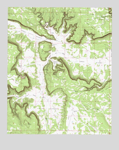
Leyba, NM USGS Topographic Map
Click on map above to begin viewing in our Map Viewer.

This topographic map contains these locations and features:
Feature Name Type Latitude Longitude GNIS ID View Map
Benada TankReservoirN35.1404°W105.5772°903741View Map
Blind WellWellN35.1917°W105.5692°903924View Map
Caņada de PuebloStreamN35.1967°W105.5400°904417View Map
Corner TankReservoirN35.1495°W105.5147°905352View Map
El Pablito Indian RuinsLocaleN35.1887°W105.5814°906066View Map
La Mesa Corral de la AguaSummitN35.2403°W105.5375°907687View Map
La Mesa PobreSummitN35.2073°W105.5870°907691View Map
LeybaLocaleN35.2250°W105.5736°907945View Map
Leyba Post OfficePost OfficeN35.2250°W105.5736°937682View Map
Leyba TankReservoirN35.2411°W105.5145°907946View Map
Lower Agua TankReservoirN35.2424°W105.5224°908264View Map
Mesa de AguilarSummitN35.1350°W105.6028°908580View Map
Mesa de la MulaSummitN35.1759°W105.6106°908577View Map
Mesa EscondidaSummitN35.1692°W105.5092°908614View Map
Mesa PortreroSummitN35.1609°W105.5520°908632View Map
North TankReservoirN35.1789°W105.5611°909199View Map
Ojo Indian RuinsLocaleN35.1642°W105.6139°909319View Map
Rincon BajitoAreaN35.1798°W105.5433°910188View Map
Rincon BonitoAreaN35.1962°W105.5697°910189View Map
Rincon ColoradoAreaN35.1503°W105.5786°910193View Map
Rincon del LeonValleyN35.2184°W105.5636°910185View Map
Rincon VigilAreaN35.1920°W105.6083°910206View Map
Rock TankReservoirN35.1673°W105.5450°910395View Map
San Francisco ChurchChurchN35.2131°W105.5708°910616View Map
ShellyLocaleN35.1489°W105.5445°924503View Map
Shelly Hayes CampLocaleN35.1475°W105.5461°911001View Map
Shelly WindmillLocaleN35.1612°W105.5811°911002View Map
Valle ChimalValleyN35.2167°W105.5631°912033View Map
Villanueva DivisionCivilN35.2353°W105.5200°1937614View Map

Note: Coordinates in the location and feature list above are referenced to NAD83 datum.


Copyright (C) 2008-2025 Ryan Niemi / Sunset Dynamics ... All Rights Reserved