TopoQuest Logo
Do you find TopoQuest useful?
Help keep TopoQuest running and adding new maps/features by donating!
Bitcoin:  19c7KJd3qBynnjoSw5npx9KScwjBe4ifkT
Litecoin:  LXs6TkuXGGXo1vDsWCkWVdjQX94eUKd6ui
Home View Maps Find Maps Find Places Resources & Links


Liberty West, New York Topographic Map

USGS Map Title: Liberty West, NY
USGS Map MRC: 41074G7
DRG (GeoTIFF) Download: o41074g7.tif


Neighboring USGS Topographic Map Quads:


  Roscoe, NY  
41074H8
 

  Livingston Manor, NY  
41074H7
 

  Willowemoc, NY  
41074H6
 

  Jeffersonville, NY  
41074G8
 

  Liberty West, NY  
41074G7
 

  Liberty East, NY  
41074G6
 

  Lake Huntington, NY  
41074F8
 

  White Lake, NY  
41074F7
 

  Monticello, NY  
41074F6


Map MRC Location:

N42°
W75°
N42°
W74°
H8 H7 H6 H5 H4 H3 H2 H1
G8 G7 G6 G5 G4 G3 G2 G1
F8 F7 F6 F5 F4 F3 F2 F1
E8 E7 E6 E5 E4 E3 E2 E1
D8 D7 D6 D5 D4 D3 D2 D1
C8 C7 C6 C5 C4 C3 C2 C1
B8 B7 B6 B5 B4 B3 B2 B1
A8 A7 A6 A5 A4 A3 A2 A1
N41°
W75°
N41°
W74°

Liberty West, NY USGS 1:24K Topographic Map Preview:
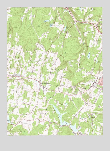
Liberty West, NY USGS Topographic Map
Click on map above to begin viewing in our Map Viewer.

This topographic map contains these locations and features:
Feature Name Type Latitude Longitude GNIS ID View Map
Achieve Rehabilitation and Nursing FacilityBuildingN41.7935°W74.7515°2599260View Map
All Souls ChapelChurchN41.8504°W74.7727°942334View Map
Benton HollowValleyN41.8607°W74.7849°943710View Map
Blueberry Hill CampLocaleN41.8359°W74.7721°944338View Map
Briscoe LakeReservoirN41.7644°W74.8737°944765View Map
Camp OlympusLocaleN41.8723°W74.7760°945636View Map
Chuck HillSummitN41.7959°W74.7752°946660View Map
Denman LakeReservoirN41.8541°W74.7989°948299View Map
Fieldston LakeLakeN41.7665°W74.7771°950027View Map
Grants HillSummitN41.8434°W74.8213°951523View Map
Hi Brow Horse FarmLocaleN41.8158°W74.8389°2554713View Map
Horseshoe BrookStreamN41.8081°W74.8585°953235View Map
Kelly BridgeBridgeN41.7604°W74.7916°954467View Map
Kingdom Hall of Jehovahs WitnessesChurchN41.7941°W74.8083°2597989View Map
Krom HollowValleyN41.7983°W74.8209°954821View Map
Lake BarnabeeLakeN41.7678°W74.7668°943026View Map
Lake MarieReservoirN41.7804°W74.7976°956516View Map
Laurel Hill CemeteryCemeteryN41.7796°W74.8298°2061714View Map
Lenape LakeReservoirN41.8616°W74.8227°955194View Map
Liberty Baptist ChurchChurchN41.8008°W74.7528°2597990View Map
Liberty Free Methodist ChurchChurchN41.7996°W74.7628°2597991View Map
Liberty High SchoolSchoolN41.8067°W74.7533°2370050View Map
Liberty Middle SchoolSchoolN41.8066°W74.7534°2597981View Map
Liberty-Loomis HospitalHospitalN41.7948°W74.7882°955280View Map
Light and Life Christian SchoolSchoolN41.7995°W74.7629°2597200View Map
LoomisPopulated PlaceN41.7973°W74.7857°955958View Map
Loomis Mobile Home ParkPopulated PlaceN41.7966°W74.7903°2599178View Map
Matawa LakeReservoirN41.8576°W74.8168°956664View Map
Melbern LakeLakeN41.8216°W74.7574°956921View Map
Old Parksville CemeteryCemeteryN41.8518°W74.7578°2554099View Map
Olympus LakeLakeN41.8737°W74.7790°959354View Map
ParksvillePopulated PlaceN41.8554°W74.7596°959925View Map
Parksville Methodist Church CemeteryCemeteryN41.8550°W74.7581°2554098View Map
Parksville Post OfficePost OfficeN41.8567°W74.7571°2599169View Map
Pearl LakeReservoirN41.8732°W74.7633°960054View Map
Pine SwampSwampN41.8303°W74.7988°960552View Map
Pine SwampSwampN41.8570°W74.8452°960553View Map
Pine SwampSwampN41.8579°W74.8326°960554View Map
Revonah HillSummitN41.8184°W74.7618°962417View Map
Revonah LakeLakeN41.8281°W74.7677°962418View Map
School Number 12 (historical)SchoolN41.8579°W74.7571°975012View Map
Shingle BrookStreamN41.8104°W74.8602°965113View Map
Spring LakeReservoirN41.8397°W74.7742°966079View Map
Sullivan County Golf and Country ClubLocaleN41.8015°W74.7648°2599197View Map
Swan LakeLakeN41.7620°W74.8024°966885View Map
Swan LakePopulated PlaceN41.7506°W74.7779°966887View Map
Swan Lake Volunteer Fire DepartmentBuildingN41.7503°W74.7769°2735426View Map
Town of LibertyCivilN41.8132°W74.7775°979149View Map
Walnut MountainSummitN41.7873°W74.7685°968714View Map
Walnut Mountain Farm And NurseryLocaleN41.7803°W74.7664°2554709View Map
White Sulphur SpringsPopulated PlaceN41.7976°W74.8268°971140View Map
White Sulphur Springs CemeteryCemeteryN41.7991°W74.8263°2554097View Map
White Sulphur Springs Fire DepartmentBuildingN41.7996°W74.8301°2718401View Map
White Sulphur Springs Post OfficePost OfficeN41.7973°W74.8264°2599235View Map
WJFF-FM (Jeffersonville)TowerN41.8162°W74.7871°977748View Map

Note: Coordinates in the location and feature list above are referenced to NAD83 datum.


Copyright (C) 2008-2025 Ryan Niemi / Sunset Dynamics ... All Rights Reserved