TopoQuest Logo
Do you find TopoQuest useful?
Help keep TopoQuest running and adding new maps/features by donating!
Bitcoin:  19c7KJd3qBynnjoSw5npx9KScwjBe4ifkT
Litecoin:  LXs6TkuXGGXo1vDsWCkWVdjQX94eUKd6ui
Home View Maps Find Maps Find Places Resources & Links


Lillington, North Carolina Topographic Map

USGS Map Title: Lillington, NC
USGS Map MRC: 35078D7
DRG (GeoTIFF) Download: o35078d7.tif


Neighboring USGS Topographic Map Quads:


  Cokesbury, NC  
35078E8
 

  Fuquay-Varina, NC  
35078E7
 

  Angier, NC  
35078E6
 

  Mamers, NC  
35078D8
 

  Lillington, NC  
35078D7
 

  Coats, NC  
35078D6
 

  Anderson Creek, NC  
35078C8
 

  Bunnlevel, NC  
35078C7
 

  Erwin, NC  
35078C6


Map MRC Location:

N36°
W79°
N36°
W78°
H8 H7 H6 H5 H4 H3 H2 H1
G8 G7 G6 G5 G4 G3 G2 G1
F8 F7 F6 F5 F4 F3 F2 F1
E8 E7 E6 E5 E4 E3 E2 E1
D8 D7 D6 D5 D4 D3 D2 D1
C8 C7 C6 C5 C4 C3 C2 C1
B8 B7 B6 B5 B4 B3 B2 B1
A8 A7 A6 A5 A4 A3 A2 A1
N35°
W79°
N35°
W78°

Lillington, NC USGS 1:24K Topographic Map Preview:
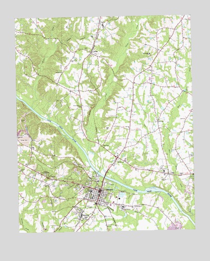
Lillington, NC USGS Topographic Map
Click on map above to begin viewing in our Map Viewer.

This topographic map contains these locations and features:
Feature Name Type Latitude Longitude GNIS ID View Map
A J White DamDamN35.4118°W78.8314°998946View Map
Bethlehem ChurchChurchN35.4682°W78.8420°981211View Map
Buies CreekStreamN35.3832°W78.7536°1019393View Map
Cape FearPopulated PlaceN35.4252°W78.8147°982616View Map
Cape Fear ChurchChurchN35.4354°W78.7950°982624View Map
Cedar Grove ChurchChurchN35.4046°W78.7717°982844View Map
Cedar Rock ChurchChurchN35.4307°W78.8742°1023898View Map
Coopers BranchStreamN35.4835°W78.8461°983513View Map
Dry CreekStreamN35.4015°W78.7972°984358View Map
Fellowship ChurchChurchN35.3899°W78.7917°985033View Map
Fish CreekStreamN35.4532°W78.8736°985095View Map
Green CemeteryCemeteryN35.4396°W78.7547°986046View Map
Green ChapelChurchN35.4082°W78.7664°986051View Map
Harnett Central High SchoolSchoolN35.4624°W78.7806°1006652View Map
Harnett Correctional InstitutionBuildingN35.3881°W78.8012°2769854View Map
Harnett County Sheriff's OfficeBuildingN35.4170°W78.8091°2769791View Map
Harnett Memorial CemeteryCemeteryN35.4174°W78.8036°986425View Map
Hector CreekStreamN35.4477°W78.8639°986590View Map
Johnson CemeteryCemeteryN35.4177°W78.7503°1024731View Map
Johnson FieldAirportN35.4851°W78.8517°2770356View Map
KiplingPopulated PlaceN35.4799°W78.8211°988017View Map
Kipling Post OfficePost OfficeN35.4790°W78.8199°2774074View Map
Lafayette SchoolSchoolN35.4957°W78.8125°988075View Map
LillingtonPopulated PlaceN35.3993°W78.8159°1021150View Map
Lillington Middle SchoolSchoolN35.3985°W78.8231°1006650View Map
Lillington Police DepartmentBuildingN35.3981°W78.8162°2769713View Map
Lillington Post OfficePost OfficeN35.3978°W78.8178°2774090View Map
Lillington Volunteer Fire DepartmentBuildingN35.3978°W78.8162°2638407View Map
Mc Coy Grove ChurchChurchN35.4488°W78.8303°989512View Map
Neills CreekStreamN35.4199°W78.8247°990901View Map
Neills Creek ChurchChurchN35.4682°W78.7775°990902View Map
North Carolina State Highway Patrol Troop B District 8BuildingN35.3923°W78.8038°2769877View Map
North Harnett SchoolSchoolN35.4782°W78.7792°991235View Map
Olive Branch CemeteryCemeteryN35.4746°W78.8359°991634View Map
Pleasant Union ChurchChurchN35.4393°W78.7745°992571View Map
Poorhouse CreekStreamN35.3968°W78.7886°992669View Map
ShawtownPopulated PlaceN35.3843°W78.8306°1022568View Map
Shawtown Elementary SchoolSchoolN35.3852°W78.8300°1006651View Map
Smith CemeteryCemeteryN35.4813°W78.8250°994946View Map
Summerville ChurchChurchN35.4032°W78.8547°995688View Map
Summerville Fire and RescueBuildingN35.3994°W78.8134°2639210View Map
Tirzah Airport (historical)AirportN35.4018°W78.8464°1024427View Map
Town of LillingtonCivilN35.4000°W78.8137°2406020View Map
Township of Hectors CreekCivilN35.4974°W78.8430°1026767View Map
Township of Neills CreekCivilN35.4248°W78.7576°1026770View Map
WCCE-FM (Buies Creek)TowerN35.4210°W78.7986°1018271View Map
Wesley ChapelChurchN35.3827°W78.8267°996963View Map
West Buies CreekStreamN35.3960°W78.7509°1024398View Map
Westview Memorial GardensCemeteryN35.4090°W78.8553°997086View Map
WLLN-AM (Lillington)TowerN35.3879°W78.8059°1018441View Map

Note: Coordinates in the location and feature list above are referenced to NAD83 datum.


Copyright (C) 2008-2025 Ryan Niemi / Sunset Dynamics ... All Rights Reserved