TopoQuest Logo
Do you find TopoQuest useful?
Help keep TopoQuest running and adding new maps/features by donating!
Bitcoin:  19c7KJd3qBynnjoSw5npx9KScwjBe4ifkT
Litecoin:  LXs6TkuXGGXo1vDsWCkWVdjQX94eUKd6ui
Home View Maps Find Maps Find Places Resources & Links


Lim Rock, Alabama Topographic Map

USGS Map Title: Lim Rock, AL
USGS Map MRC: 34086F2
DRG (GeoTIFF) Download: o34086f2.tif


Neighboring USGS Topographic Map Quads:


  Hollytree, AL  
34086G3
 

  Princeton, AL  
34086G2
 

  Mud Creek, AL  
34086G1
 

  Paint Rock, AL  
34086F3
 

  Lim Rock, AL  
34086F2
 

  Scottsboro, AL  
34086F1
 

  Grant, AL  
34086E3
 

  Swearengin, AL  
34086E2
 

  Langston, AL  
34086E1


Map MRC Location:

N35°
W87°
N35°
W86°
H8 H7 H6 H5 H4 H3 H2 H1
G8 G7 G6 G5 G4 G3 G2 G1
F8 F7 F6 F5 F4 F3 F2 F1
E8 E7 E6 E5 E4 E3 E2 E1
D8 D7 D6 D5 D4 D3 D2 D1
C8 C7 C6 C5 C4 C3 C2 C1
B8 B7 B6 B5 B4 B3 B2 B1
A8 A7 A6 A5 A4 A3 A2 A1
N34°
W87°
N34°
W86°

Lim Rock, AL USGS 1:24K Topographic Map Preview:
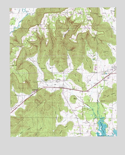
Lim Rock, AL USGS Topographic Map
Click on map above to begin viewing in our Map Viewer.

This topographic map contains these locations and features:
Feature Name Type Latitude Longitude GNIS ID View Map
Aspel BranchStreamN34.6251°W86.1478°113259View Map
Beasley PondLakeN34.6860°W86.1372°113698View Map
Berry CemeteryCemeteryN34.6923°W86.2036°113959View Map
Berrys CoveValleyN34.6840°W86.1939°113973View Map
Bethlehem ChurchChurchN34.6793°W86.2089°114150View Map
Blue SpringSpringN34.6732°W86.1398°114572View Map
Blue Spring CemeteryCemeteryN34.6867°W86.1391°114584View Map
Blue Spring CoveValleyN34.6906°W86.1403°114586View Map
Blue Spring CreekStreamN34.6437°W86.1458°114587View Map
Caney CoveValleyN34.6409°W86.1691°115571View Map
Caney Cove CreekStreamN34.6381°W86.1566°139126View Map
Carver HollowValleyN34.6381°W86.1950°115677View Map
Coffey NarrowsGapN34.7126°W86.2344°116363View Map
Cotton MountainSummitN34.6645°W86.1319°116687View Map
Dotson CemeteryCemeteryN34.6792°W86.2066°117398View Map
Erwin CemeteryCemeteryN34.6781°W86.2178°118022View Map
Farr HollowValleyN34.6626°W86.2358°118210View Map
Flippo FordCrossingN34.7273°W86.2478°156359View Map
Frasier SpringSpringN34.6916°W86.2140°118607View Map
Gentle CemeteryCemeteryN34.6787°W86.2147°118895View Map
Gentles CoveValleyN34.6840°W86.1858°118896View Map
Gold CemeteryCemeteryN34.7454°W86.1661°119085View Map
Gormley RidgeRidgeN34.6487°W86.1922°119183View Map
Guess CreekStreamN34.7454°W86.2286°154457View Map
Gullet RidgeRidgeN34.6515°W86.1614°119465View Map
Hall CemeteryCemeteryN34.7040°W86.1514°119578View Map
Hall HollowValleyN34.6806°W86.1583°139181View Map
Harrison CemeteryCemeteryN34.6948°W86.2194°119817View Map
Isbell CemeteryCemeteryN34.6898°W86.1800°120710View Map
Isbell SpringSpringN34.6884°W86.1876°120711View Map
J5 Mike AirportAirportN34.6654°W86.2208°2717148View Map
Jennies ChapelChurchN34.6504°W86.1775°120849View Map
Kennedy MineMineN34.7465°W86.2283°145656View Map
Leslie RidgeRidgeN34.6823°W86.1716°121505View Map
Letcher Church of GodChurchN34.7406°W86.1583°154470View Map
Lim RockPopulated PlaceN34.6723°W86.1883°154471View Map
Lim Rock SchoolSchoolN34.6801°W86.1953°121631View Map
Limrock - Aspel Volunteer Fire DepartmentBuildingN34.6715°W86.1867°2682739View Map
Little MountainSummitN34.6612°W86.1769°152104View Map
Lizzard RidgeRidgeN34.6959°W86.1583°121932View Map
Long Pond (historical)LakeN34.6898°W86.1347°1700334View Map
McAllister SinksBasinN34.7265°W86.1839°152259View Map
McCoy MountainSummitN34.6595°W86.2100°122497View Map
Mount Ararat ChurchChurchN34.6790°W86.1964°123145View Map
Mount Pleasant CemeteryCemeteryN34.6945°W86.2472°123352View Map
Mount Pleasant Church (historical)ChurchN34.6948°W86.2469°139226View Map
Nat MountainSummitN34.6954°W86.2489°123647View Map
Naught MineMineN34.7395°W86.1925°1700335View Map
Ned HoleLakeN34.6543°W86.1658°1700336View Map
Pace CemeteryCemeteryN34.7442°W86.1408°124366View Map
Peters Cove CemeteryCemeteryN34.6654°W86.2403°124643View Map
Pierceton (historical)Populated PlaceN34.7279°W86.1972°149589View Map
Pierceton ChurchChurchN34.7306°W86.2183°139247View Map
Pierceton School (historical)SchoolN34.7315°W86.2119°169325View Map
Pleasant Grove ChurchChurchN34.7326°W86.2133°154515View Map
Pleasant Grove Volunteer Fire DepartmentBuildingN34.7328°W86.2140°2683304View Map
Proctor Pond (historical)LakeN34.6873°W86.1522°1700337View Map
Reese PondLakeN34.6789°W86.1369°125538View Map
Saint Elizabeth ChapelChurchN34.6868°W86.1478°126088View Map
Schiffman CoveValleyN34.6759°W86.2128°153347View Map
Seabolt SpringSpringN34.6593°W86.1438°126502View Map
Selby SpringSpringN34.7410°W86.1414°126530View Map
Shelton MineMineN34.7343°W86.1655°1700339View Map
Soap GapGapN34.6901°W86.1733°127086View Map
Stephens GapGapN34.6706°W86.2178°127361View Map
Talkington BranchStreamN34.7370°W86.1300°127639View Map
Town of Pleasant GrovesCivilN34.7350°W86.2054°2407134View Map
Trenton CemeteryCemeteryN34.7454°W86.2461°149599View Map
Turtle Pond (historical)LakeN34.6518°W86.1753°1700342View Map
Webb CemeteryCemeteryN34.7392°W86.2491°128681View Map
WiningerPopulated PlaceN34.7429°W86.1594°157270View Map
Wininger SchoolSchoolN34.7440°W86.1658°129119View Map
Wrights RidgeRidgeN34.6306°W86.1919°154041View Map
Yellow BranchStreamN34.6440°W86.1491°129285View Map
Yellow PondLakeN34.6426°W86.1519°1700347View Map

Note: Coordinates in the location and feature list above are referenced to NAD83 datum.


Copyright (C) 2008-2024 Ryan Niemi / Sunset Dynamics ... All Rights Reserved