TopoQuest Logo
Do you find TopoQuest useful?
Help keep TopoQuest running and adding new maps/features by donating!
Bitcoin:  19c7KJd3qBynnjoSw5npx9KScwjBe4ifkT
Litecoin:  LXs6TkuXGGXo1vDsWCkWVdjQX94eUKd6ui
Home View Maps Find Maps Find Places Resources & Links


Lindsay, Oklahoma Topographic Map

USGS Map Title: Lindsay, OK
USGS Map MRC: 34097G5
DRG (GeoTIFF) Download: o34097g5.tif


Neighboring USGS Topographic Map Quads:


  Bradley, OK  
34097H6
 

  Criner, OK  
34097H5
 

  Stealy, OK  
34097H4
 

  Lindsay SW, OK  
34097G6
 

  Lindsay, OK  
34097G5
 

  Maysville, OK  
34097G4
 

  Cox City, OK  
34097F6
 

  Purdy, OK  
34097F5
 

  Elmore City North, OK  
34097F4


Map MRC Location:

N35°
W98°
N35°
W97°
H8 H7 H6 H5 H4 H3 H2 H1
G8 G7 G6 G5 G4 G3 G2 G1
F8 F7 F6 F5 F4 F3 F2 F1
E8 E7 E6 E5 E4 E3 E2 E1
D8 D7 D6 D5 D4 D3 D2 D1
C8 C7 C6 C5 C4 C3 C2 C1
B8 B7 B6 B5 B4 B3 B2 B1
A8 A7 A6 A5 A4 A3 A2 A1
N34°
W98°
N34°
W97°

Lindsay, OK USGS 1:24K Topographic Map Preview:
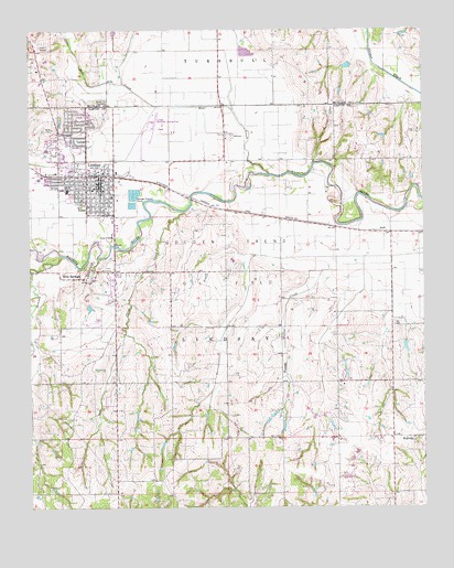
Lindsay, OK USGS Topographic Map
Click on map above to begin viewing in our Map Viewer.

This topographic map contains these locations and features:
Feature Name Type Latitude Longitude GNIS ID View Map
Bear CreekStreamN34.8370°W97.5492°1089905View Map
Bear Hybarger Site 5 DamDamN34.8734°W97.5986°1759113View Map
Bear Hybarger Site 5 ReservoirReservoirN34.8734°W97.5986°1759114View Map
Calvary Baptist ChurchChurchN34.8348°W97.6078°1798512View Map
Cavel CreekStreamN34.8273°W97.5767°1091054View Map
Christian ChurchChurchN34.8356°W97.6075°1798513View Map
City of LindsayCivilN34.8393°W97.6104°2410840View Map
Daugherty Gss Number 1 DamDamN34.7651°W97.6086°1753634View Map
Daugherty Gss Number 1 ReservoirReservoirN34.7651°W97.6086°1753635View Map
Erin SpringsPopulated PlaceN34.8109°W97.6067°1092635View Map
Erin Springs CemeteryCemeteryN34.8128°W97.6003°2708959View Map
First Baptist ChurchChurchN34.8334°W97.6056°1798514View Map
Golden Trend Oil FieldOilfieldN34.8045°W97.5642°1093236View Map
Green Hill CemeteryCemeteryN34.8562°W97.6027°1093372View Map
Hughes SchoolSchoolN34.7823°W97.5248°1094000View Map
Hybarger CreekStreamN34.8551°W97.5836°1094037View Map
LindsayPopulated PlaceN34.8348°W97.6025°1094691View Map
Lindsay DivisionCivilN34.7768°W97.5685°1937758View Map
Lindsay Elementary SchoolSchoolN34.8330°W97.6135°1793750View Map
Lindsay Emergency Medical ServicesBuildingN34.8338°W97.6039°2695871View Map
Lindsay Fire DepartmentBuildingN34.8338°W97.6037°2658295View Map
Lindsay High SchoolSchoolN34.8343°W97.6130°1793751View Map
Lindsay Middle SchoolSchoolN34.8334°W97.6136°1793752View Map
Lindsay Municipal AirportAirportN34.8499°W97.5870°1102536View Map
Lindsay Police DepartmentBuildingN34.8326°W97.6025°2757608View Map
Maysville Laterals Site H-34 DamDamN34.7817°W97.5686°1755033View Map
Maysville Laterals Site H-34 ReservoirReservoirN34.7817°W97.5686°1755034View Map
Maysville Laterals Site H2 DamDamN34.8151°W97.5603°1758231View Map
Maysville Laterals Site H2 ReservoirReservoirN34.8151°W97.5603°1758232View Map
Maysville Laterals Site H5 DamDamN34.7817°W97.5236°1758225View Map
Maysville Laterals Site H5 ReservoirReservoirN34.7817°W97.5236°1758226View Map
Maysville Laterals Site H6 DamDamN34.7901°W97.5436°1758227View Map
Maysville Laterals Site H6 ReservoirReservoirN34.7901°W97.5436°1758228View Map
Maysville Laterals Site H7 DamDamN34.7751°W97.5336°1758229View Map
Maysville Laterals Site H7 ReservoirReservoirN34.7751°W97.5336°1758230View Map
NeillPopulated PlaceN34.8217°W97.5125°1100667View Map
Oknoname 04916 DamDamN34.7917°W97.5070°1755651View Map
Oknoname 04916 ReservoirReservoirN34.7917°W97.5070°1755652View Map
Oknoname 04917 DamDamN34.8034°W97.6070°1755653View Map
Oknoname 04917 ReservoirReservoirN34.8034°W97.6070°1755654View Map
Rounds CreekStreamN34.8159°W97.6153°1097509View Map
Saint Michaels Episcopal ChurchChurchN34.8515°W97.6075°1798515View Map
Town of Erin SpringsCivilN34.8114°W97.6054°2412600View Map
Township of LindsayCivilN34.7917°W97.5642°1824726View Map
WallvillePopulated PlaceN34.7681°W97.5039°1099315View Map

Note: Coordinates in the location and feature list above are referenced to NAD83 datum.


Copyright (C) 2008-2024 Ryan Niemi / Sunset Dynamics ... All Rights Reserved