TopoQuest Logo
Do you find TopoQuest useful?
Help keep TopoQuest running and adding new maps/features by donating!
Bitcoin:  19c7KJd3qBynnjoSw5npx9KScwjBe4ifkT
Litecoin:  LXs6TkuXGGXo1vDsWCkWVdjQX94eUKd6ui
Home View Maps Find Maps Find Places Resources & Links


Little Kandiyohi Lake, Minnesota Topographic Map

USGS Map Title: Little Kandiyohi Lake, MN
USGS Map MRC: 45094A8
DRG (GeoTIFF) Download: o45094a8.tif


Neighboring USGS Topographic Map Quads:


  Solomon Lake, MN  
45095B1
 

  Spicer, MN  
45094B8
 

  Atwater, MN  
45094B7
 

  Willmar, MN  
45095A1
 

  Little Kandiyohi Lake, MN  
45094A8
 

  Lake Elizabeth, MN  
45094A7
 

  Blomkest, MN  
44095H1
 

  Lake Lillian, MN  
44094H8
 

  Thorpe, MN  
44094H7


Map MRC Location:

N46°
W95°
N46°
W94°
H8 H7 H6 H5 H4 H3 H2 H1
G8 G7 G6 G5 G4 G3 G2 G1
F8 F7 F6 F5 F4 F3 F2 F1
E8 E7 E6 E5 E4 E3 E2 E1
D8 D7 D6 D5 D4 D3 D2 D1
C8 C7 C6 C5 C4 C3 C2 C1
B8 B7 B6 B5 B4 B3 B2 B1
A8 A7 A6 A5 A4 A3 A2 A1
N45°
W95°
N45°
W94°

Little Kandiyohi Lake, MN USGS 1:24K Topographic Map Preview:
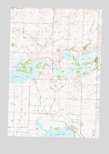
Little Kandiyohi Lake, MN USGS Topographic Map
Click on map above to begin viewing in our Map Viewer.

This topographic map contains these locations and features:
Feature Name Type Latitude Longitude GNIS ID View Map
Bethesda CemeteryCemeteryN45.0149°W94.9927°1815525View Map
Big Kandiyohi ChannelCanalN45.0200°W94.9819°1815524View Map
Branch Number FourCanalN45.0314°W94.9567°1815523View Map
Cherry LakeLakeN45.0604°W94.8765°641145View Map
County Ditch Number SixtyfourCanalN45.0041°W94.9836°1815526View Map
County Ditch Number Twentythree ACanalN45.0833°W94.9997°1815535View Map
County Park Number TwoParkN45.0089°W94.9108°1815522View Map
Fanny LakeLakeN45.0375°W94.9572°643557View Map
Judicial Ditch Number OneCanalN45.0005°W94.8989°1815534View Map
Kandiyohi LakeReservoirN45.0083°W94.9136°1775991View Map
Kandiyohi Lake Inlet DamDamN45.0083°W94.9136°1775990View Map
Kandiyohi Methodist Episcopal ChurchChurchN45.0661°W94.9583°2067762View Map
Kasota LakeLakeN45.0775°W94.8956°646048View Map
Lake EleanorLakeN45.0693°W94.9878°643236View Map
Lake WakandaLakeN45.0589°W94.9892°653718View Map
Little Kandiyohi LakeReservoirN45.0716°W94.9469°1775989View Map
Little Kandiyohi LakeLakeN45.0654°W94.9111°646827View Map
Little Kandiyohi Lake DamDamN45.0716°W94.9469°1775988View Map
Oak Hill CemeteryCemeteryN45.0540°W94.9638°648815View Map
Oak Park CemeteryCemeteryN45.0691°W94.9463°2067764View Map
Oak Park ChurchChurchN45.0694°W94.9469°648846View Map
Old Baptist CemeteryCemeteryN45.0807°W94.9952°2067763View Map
School Number 39SchoolN45.0561°W94.9417°651648View Map
School Number 61SchoolN45.0950°W94.9675°651697View Map
School Number 68SchoolN45.0161°W94.9914°651715View Map
School Number 79SchoolN45.0486°W94.8808°651739View Map
Swan LakeLakeN45.0796°W94.9207°652886View Map
Township of FahlunCivilN45.0230°W94.9411°664126View Map
Township of KandiyohiCivilN45.1099°W94.9408°664597View Map
Tripolis CemeteryCemeteryN45.0925°W94.9406°2067765View Map
Tripolis ChurchChurchN45.0930°W94.9408°653326View Map

Note: Coordinates in the location and feature list above are referenced to NAD83 datum.


Copyright (C) 2008-2024 Ryan Niemi / Sunset Dynamics ... All Rights Reserved