TopoQuest Logo
Do you find TopoQuest useful?
Help keep TopoQuest running and adding new maps/features by donating!
Bitcoin:  19c7KJd3qBynnjoSw5npx9KScwjBe4ifkT
Litecoin:  LXs6TkuXGGXo1vDsWCkWVdjQX94eUKd6ui
Home View Maps Find Maps Find Places Resources & Links


Livermore Mountain, Colorado Topographic Map

USGS Map Title: Livermore Mountain, CO
USGS Map MRC: 40105G3
DRG (GeoTIFF) Download: o40105g3.tif


Neighboring USGS Topographic Map Quads:


  Cherokee Park, CO  
40105H4
 

  Virginia Dale, CO  
40105H3
 

  Table Mountain, CO  
40105H2
 

  Haystack Gulch, CO  
40105G4
 

  Livermore Mountain, CO  
40105G3
 

  Livermore, CO  
40105G2
 

  Big Narrows, CO  
40105F4
 

  Poudre Park, CO  
40105F3
 

  Laporte, CO  
40105F2


Map MRC Location:

N41°
W106°
N41°
W105°
H8 H7 H6 H5 H4 H3 H2 H1
G8 G7 G6 G5 G4 G3 G2 G1
F8 F7 F6 F5 F4 F3 F2 F1
E8 E7 E6 E5 E4 E3 E2 E1
D8 D7 D6 D5 D4 D3 D2 D1
C8 C7 C6 C5 C4 C3 C2 C1
B8 B7 B6 B5 B4 B3 B2 B1
A8 A7 A6 A5 A4 A3 A2 A1
N40°
W106°
N40°
W105°

Livermore Mountain, CO USGS 1:24K Topographic Map Preview:
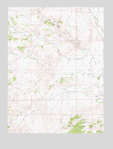
Livermore Mountain, CO USGS Topographic Map
Click on map above to begin viewing in our Map Viewer.

This topographic map contains these locations and features:
Feature Name Type Latitude Longitude GNIS ID View Map
Calloway HillSummitN40.8305°W105.3094°170193View Map
Cherokee Stage Station CemeteryCemeteryN40.8614°W105.2572°2036945View Map
Christopher Charles Cradock GraveCemeteryN40.8239°W105.2805°2036948View Map
Elliott Ranch CemeteryCemeteryN40.8269°W105.3644°2036983View Map
Lamb Family CemeteryCemeteryN40.7836°W105.2536°2036960View Map
LivermoreLocaleN40.7864°W105.2569°170196View Map
Livermore CemeteryCemeteryN40.8183°W105.2611°170197View Map
Livermore Fire Protection District Cherokee Park Station 2BuildingN40.8566°W105.3705°2667026View Map
Livermore MountainSummitN40.7569°W105.2925°170194View Map
Lone Pine CreekStreamN40.7980°W105.2586°170208View Map
Lonetree CreekStreamN40.8694°W105.2608°196535View Map
Middle Fork Rabbit CreekStreamN40.8261°W105.3472°170210View Map
Mitchell Weymouth Ditch 1CanalN40.7946°W105.3030°2723556View Map
North Fork Rabbit CreekStreamN40.8261°W105.3472°170211View Map
Overland TrailTrailN40.8500°W105.3339°201897View Map
Rabbit CreekStreamN40.8080°W105.2686°170195View Map
Sixmile CreekStreamN40.8519°W105.3372°170140View Map
South Fork Rabbit CreekStreamN40.8108°W105.3292°170209View Map
Stonewall CreekStreamN40.8055°W105.2561°170143View Map
Tenmile CreekStreamN40.8639°W105.2589°170142View Map
Upper Stonewall DamDamN40.8216°W105.2539°201314View Map
Upper Stonewall ReservoirReservoirN40.8222°W105.2530°201315View Map

Note: Coordinates in the location and feature list above are referenced to NAD83 datum.


Copyright (C) 2008-2025 Ryan Niemi / Sunset Dynamics ... All Rights Reserved