TopoQuest Logo
Do you find TopoQuest useful?
Help keep TopoQuest running and adding new maps/features by donating!
Bitcoin:  19c7KJd3qBynnjoSw5npx9KScwjBe4ifkT
Litecoin:  LXs6TkuXGGXo1vDsWCkWVdjQX94eUKd6ui
Home View Maps Find Maps Find Places Resources & Links


Lopez Mountain, California Topographic Map

USGS Map Title: Lopez Mountain, CA
USGS Map MRC: 35120C5
DRG (GeoTIFF) Download: o35120c5.tif


Neighboring USGS Topographic Map Quads:


  Atascadero, CA  
35120D6
 

  Santa Margarita, CA  
35120D5
 

  Wilson Corner, CA  
35120D4
 

  San Luis Obispo, CA  
35120C6
 

  Lopez Mountain, CA  
35120C5
 

  Santa Margarita Lake, CA  
35120C4
 

  Pismo Beach, CA  
35120B6
 

  Arroyo Grande NE, CA  
35120B5
 

  Tar Spring Ridge, CA  
35120B4


Map MRC Location:

N36°
W121°
N36°
W120°
H8 H7 H6 H5 H4 H3 H2 H1
G8 G7 G6 G5 G4 G3 G2 G1
F8 F7 F6 F5 F4 F3 F2 F1
E8 E7 E6 E5 E4 E3 E2 E1
D8 D7 D6 D5 D4 D3 D2 D1
C8 C7 C6 C5 C4 C3 C2 C1
B8 B7 B6 B5 B4 B3 B2 B1
A8 A7 A6 A5 A4 A3 A2 A1
N35°
W121°
N35°
W120°

Lopez Mountain, CA USGS 1:24K Topographic Map Preview:
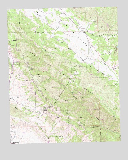
Lopez Mountain, CA USGS Topographic Map
Click on map above to begin viewing in our Map Viewer.

This topographic map contains these locations and features:
Feature Name Type Latitude Longitude GNIS ID View Map
Bald HillSummitN35.2758°W120.5774°1660293View Map
Big Falls CanyonValleyN35.2605°W120.5129°269825View Map
Black ButteSummitN35.3122°W120.5921°269878View Map
Burrito CreekStreamN35.3369°W120.5327°270102View Map
Fern CanyonValleyN35.2633°W120.5213°242207View Map
Fivemile BridgeBridgeN35.3530°W120.5379°271152View Map
Gay MountainSummitN35.2889°W120.5629°271288View Map
Hampton CanyonValleyN35.2772°W120.6052°271485View Map
Lopez MountainSummitN35.3014°W120.5782°272209View Map
Miller FlatFlatN35.3725°W120.5907°272479View Map
Mount LoweSummitN35.3194°W120.6007°1660960View Map
Oil Well CanyonValleyN35.2605°W120.5860°272771View Map
Pilitas CreekStreamN35.3497°W120.5124°272966View Map
Piney RidgeRidgeN35.2778°W120.5616°273009View Map
Potrero CreekStreamN35.2864°W120.5441°273103View Map
Rinconada CreekStreamN35.3614°W120.5335°273288View Map
Salinas DamDamN35.3372°W120.5110°1664692View Map
Santa Lucia WildernessReserveN35.2766°W120.5026°2035287View Map
Santa MargaritaCivilN35.3550°W120.5543°273556View Map
Sulphur Pot Rustic CampsiteLocaleN35.2944°W120.5538°275205View Map
Sulphur PotsSpringN35.2955°W120.5541°273946View Map
Sycamore CanyonValleyN35.3589°W120.5852°250196View Map
Upper Lopez CampgroundLocaleN35.3050°W120.5671°274289View Map
Water CanyonValleyN35.3386°W120.5879°274392View Map

Note: Coordinates in the location and feature list above are referenced to NAD83 datum.


Copyright (C) 2008-2025 Ryan Niemi / Sunset Dynamics ... All Rights Reserved