TopoQuest Logo
Do you find TopoQuest useful?
Help keep TopoQuest running and adding new maps/features by donating!
Bitcoin:  19c7KJd3qBynnjoSw5npx9KScwjBe4ifkT
Litecoin:  LXs6TkuXGGXo1vDsWCkWVdjQX94eUKd6ui
Home View Maps Find Maps Find Places Resources & Links


Louisville, New York Topographic Map

USGS Map Title: Louisville, NY
USGS Map MRC: 44075H1
DRG (GeoTIFF) Download: o44075h1.tif


Neighboring USGS Topographic Map Quads:


  Morrisburg, ON  
44075H2
 

  Louisville, NY  
44075H1
 

  Massena, NY  
44074H8
 

  Waddington, NY  
44075G2
 

  Chase Mills, NY  
44075G1
 

  Norfolk, NY  
44074G8


Map MRC Location:

N45°
W76°
N45°
W75°
H8 H7 H6 H5 H4 H3 H2 H1
G8 G7 G6 G5 G4 G3 G2 G1
F8 F7 F6 F5 F4 F3 F2 F1
E8 E7 E6 E5 E4 E3 E2 E1
D8 D7 D6 D5 D4 D3 D2 D1
C8 C7 C6 C5 C4 C3 C2 C1
B8 B7 B6 B5 B4 B3 B2 B1
A8 A7 A6 A5 A4 A3 A2 A1
N44°
W76°
N44°
W75°

Louisville, NY USGS 1:24K Topographic Map Preview:
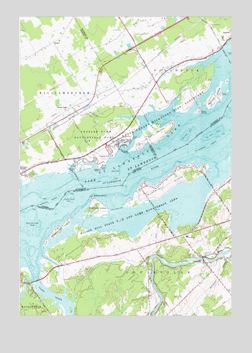
Louisville, NY USGS Topographic Map
Click on map above to begin viewing in our Map Viewer.

This topographic map contains these locations and features:
Feature Name Type Latitude Longitude GNIS ID View Map
Bradford Cemetery (historical)CemeteryN44.9233°W75.0814°2120157View Map
Bradford IslandIslandN44.9209°W75.0799°976009View Map
Bradford PointCapeN44.9250°W75.0819°976010View Map
Cat Island (historical)IslandN44.9514°W75.0122°975812View Map
Cat Island ShoalBarN44.9506°W75.0105°976086View Map
Coles CreekStreamN44.8962°W75.1160°976166View Map
Coles Creek MarinaLocaleN44.8896°W75.1218°2599071View Map
Crysler ShoalBarN44.9237°W75.0955°976210View Map
Gooseneck Island (historical)IslandN44.9125°W75.1164°2120175View Map
Lawrence Cemetery (historical)CemeteryN44.9144°W75.0958°2120158View Map
Leading LightLocaleN44.9539°W75.0063°975851View Map
LouisvillePopulated PlaceN44.8975°W75.0158°976605View Map
Louisville CornerLocaleN44.9083°W75.0272°2120180View Map
Louisville CornerPopulated PlaceN44.9092°W75.0283°975852View Map
Louisville SchoolSchoolN44.9084°W75.0263°976607View Map
Louisville Volunteer Fire Department Station 1BuildingN44.8936°W75.0120°2735278View Map
Nichols HillSummitN44.9097°W75.1033°2120185View Map
Nichols Hill IslandIslandN44.9112°W75.1008°976722View Map
Saint Lawrence CemeteryCemeteryN44.9003°W75.0155°976927View Map
Saint Lawrence ChurchChurchN44.8999°W75.0149°2597608View Map
School Number 1 (historical)SchoolN44.8903°W75.1122°2120181View Map
School Number 13 (historical)SchoolN44.9333°W75.0403°2120184View Map
School Number 2 (historical)SchoolN44.9039°W75.0528°2120182View Map
School Number 6 (historical)SchoolN44.8936°W75.0117°2120183View Map
Strawberry Island (historical)IslandN44.9181°W75.1033°2120176View Map
Town of LouisvilleCivilN44.9066°W75.0138°979170View Map
Treasure Island (historical)IslandN44.9283°W75.0622°2120179View Map
Wilson HillSummitN44.9256°W75.0522°2120375View Map
Wilson Hill IslandIslandN44.9295°W75.0394°977284View Map
Wilson Hill State Fish and Game ManagemenParkN44.9150°W75.0602°977285View Map
Wright Cemetery (historical)CemeteryN44.9147°W75.0953°2120159View Map

Note: Coordinates in the location and feature list above are referenced to NAD83 datum.


Copyright (C) 2008-2025 Ryan Niemi / Sunset Dynamics ... All Rights Reserved