TopoQuest Logo
Do you find TopoQuest useful?
Help keep TopoQuest running and adding new maps/features by donating!
Bitcoin:  19c7KJd3qBynnjoSw5npx9KScwjBe4ifkT
Litecoin:  LXs6TkuXGGXo1vDsWCkWVdjQX94eUKd6ui
Home View Maps Find Maps Find Places Resources & Links


Loveland, Iowa Topographic Map

USGS Map Title: Loveland, IA
USGS Map MRC: 41095D8
DRG (GeoTIFF) Download: o41095d8.tif


Neighboring USGS Topographic Map Quads:


  Modale, IA  
41096E1
 

  Missouri Valley, IA  
41095E8
 

  Beebeetown, IA  
41095E7
 

  Fort Calhoun, NE  
41096D1
 

  Loveland, IA  
41095D8
 

  Honey Creek, IA  
41095D7
 

  Irvington, NE  
41096C1
 

  Omaha North, NE  
41095C8
 

  Council Bluffs North, IA  
41095C7


Map MRC Location:

N42°
W96°
N42°
W95°
H8 H7 H6 H5 H4 H3 H2 H1
G8 G7 G6 G5 G4 G3 G2 G1
F8 F7 F6 F5 F4 F3 F2 F1
E8 E7 E6 E5 E4 E3 E2 E1
D8 D7 D6 D5 D4 D3 D2 D1
C8 C7 C6 C5 C4 C3 C2 C1
B8 B7 B6 B5 B4 B3 B2 B1
A8 A7 A6 A5 A4 A3 A2 A1
N41°
W96°
N41°
W95°

Loveland, IA USGS 1:24K Topographic Map Preview:
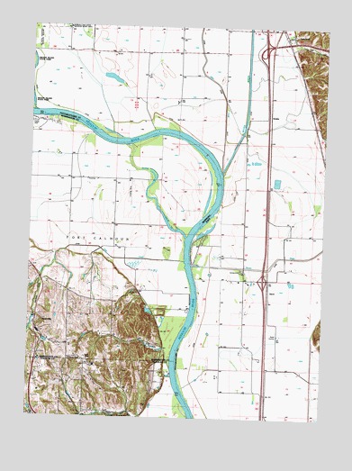
Loveland, IA USGS Topographic Map
Click on map above to begin viewing in our Map Viewer.

This topographic map contains these locations and features:
Feature Name Type Latitude Longitude GNIS ID View Map
Allen CreekStreamN41.4530°W95.9192°454133View Map
AscotPopulated PlaceN41.4136°W95.8983°464240View Map
Ascot (historical)LocaleN41.4136°W95.8983°1949710View Map
Ascot Post Office (historical)Post OfficeN41.4136°W95.8983°1949709View Map
Boyer BendBendN41.4487°W95.9193°464400View Map
Boyer ChuteStreamN41.4453°W95.9470°827606View Map
Boyer Chute National Wildlife RefugeParkN41.4487°W95.9316°1897754View Map
Boyer Chute TrailsTrailN41.4500°W95.9336°1897668View Map
Boyer RiverStreamN41.4530°W95.9192°454793View Map
Cabannes Trading Post (historical)LocaleN41.3756°W95.9586°1899376View Map
Deer CreekStreamN41.4250°W95.9342°828652View Map
Exley DamDamN41.4071°W95.9978°1769636View Map
Exley ReservoirReservoirN41.4045°W95.9985°1769637View Map
GrablePopulated PlaceN41.4708°W95.8997°464239View Map
GrableLocaleN41.4708°W95.8981°1949699View Map
Grable Post Office (historical)Post OfficeN41.4708°W95.8997°1949698View Map
Heaton AirportAirportN41.4491°W95.9573°837557View Map
Honey CreekStreamN41.4236°W95.9311°457617View Map
Honey Creek CampgroundLocaleN41.4222°W95.9100°1949448View Map
Honey Lake (historical)LakeN41.4083°W95.8845°465488View Map
Hummel ParkParkN41.3753°W95.9583°830199View Map
Interchange 66CrossingN41.4194°W95.9003°1949524View Map
Interchange 71CrossingN41.4939°W95.9011°1949526View Map
Interchange 72CrossingN41.4994°W95.9014°1949525View Map
Jungbluth DamDamN41.3983°W95.9553°1769644View Map
Jungbluth ReservoirReservoirN41.3983°W95.9553°1769645View Map
LovelandPopulated PlaceN41.4972°W95.8900°458646View Map
LovelandLocaleN41.4972°W95.8925°1949697View Map
Loveland Census Designated PlaceCensusN41.4974°W95.8910°2583486View Map
Loveland Post Office (historical)Post OfficeN41.4972°W95.8900°1949696View Map
Lower Calhoun BendBendN41.4632°W95.9615°464399View Map
McCarthy DamDamN41.4006°W95.9678°1767283View Map
McCarthy ReservoirReservoirN41.4000°W95.9670°1767284View Map
NashvillePopulated PlaceN41.4064°W95.9967°831564View Map
Nashville (historical)LocaleN41.4064°W95.9967°1897641View Map
Nashville Post Office (historical)Post OfficeN41.4064°W95.9967°1897642View Map
Neale Woods Nature CenterParkN41.3889°W95.9503°1900039View Map
Ponca Elementary SchoolSchoolN41.3753°W95.9767°832304View Map
Ponca Hills Volunteer Fire DepartmentBuildingN41.3751°W95.9768°1900074View Map
Shipley CemeteryCemeteryN41.3935°W95.9828°833407View Map
Shipley Cemetery Historical MarkerParkN41.3756°W95.9770°1900073View Map
Township of RockfordCivilN41.4701°W95.9096°468634View Map
WillowLocaleN41.4855°W95.8853°466064View Map
Willow Post Office (historical)Post OfficeN41.4722°W95.8786°1949695View Map

Note: Coordinates in the location and feature list above are referenced to NAD83 datum.


Copyright (C) 2008-2024 Ryan Niemi / Sunset Dynamics ... All Rights Reserved