TopoQuest Logo
Do you find TopoQuest useful?
Help keep TopoQuest running and adding new maps/features by donating!
Bitcoin:  19c7KJd3qBynnjoSw5npx9KScwjBe4ifkT
Litecoin:  LXs6TkuXGGXo1vDsWCkWVdjQX94eUKd6ui
Home View Maps Find Maps Find Places Resources & Links


Lundy, California Topographic Map

USGS Map Title: Lundy, CA
USGS Map MRC: 38119A2
DRG (GeoTIFF) Download: o38119a2.tif


Neighboring USGS Topographic Map Quads:


  Twin Lakes, CA  
38119B3
 

  Big Alkali, CA  
38119B2
 

  Bodie, CA  
38119B1
 

  Dunderberg Peak, CA  
38119A3
 

  Lundy, CA  
38119A2
 

  Negit Island, CA  
38119A1
 

  Tioga Pass, CA  
37119H3
 

  Mount Dana, CA  
37119H2
 

  Lee Vining, CA  
37119H1


Map MRC Location:

N39°
W120°
N39°
W119°
H8 H7 H6 H5 H4 H3 H2 H1
G8 G7 G6 G5 G4 G3 G2 G1
F8 F7 F6 F5 F4 F3 F2 F1
E8 E7 E6 E5 E4 E3 E2 E1
D8 D7 D6 D5 D4 D3 D2 D1
C8 C7 C6 C5 C4 C3 C2 C1
B8 B7 B6 B5 B4 B3 B2 B1
A8 A7 A6 A5 A4 A3 A2 A1
N38°
W120°
N38°
W119°

Lundy, CA USGS 1:24K Topographic Map Preview:
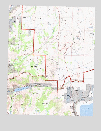
Lundy, CA USGS Topographic Map
Click on map above to begin viewing in our Map Viewer.

This topographic map contains these locations and features:
Feature Name Type Latitude Longitude GNIS ID View Map
Bacon GulchValleyN38.0799°W119.1457°256411View Map
Blue LakeLakeN38.0033°W119.2457°257251View Map
Bureau of Land Management - Mono Lake Fire StationBuildingN38.0390°W119.1689°2623925View Map
Conway Guard StationLocaleN38.0858°W119.1932°274807View Map
Conway RanchLocaleN38.0702°W119.1604°258664View Map
Conway SummitGapN38.0880°W119.1818°258665View Map
Copper MountainSummitN38.0455°W119.1954°258707View Map
Crystal LakeLakeN38.0005°W119.2461°258963View Map
Danburg BeachBeachN38.0149°W119.1357°259038View Map
Dechambeau CreekStreamN38.0138°W119.1482°259171View Map
Deer CreekStreamN38.0308°W119.2193°259205View Map
Dunderberg CreekStreamN38.1246°W119.2138°259612View Map
Gilcrest PeakSummitN38.0110°W119.2302°1658610View Map
Jordan SpringSpringN38.0562°W119.2110°274808View Map
Lake CanyonValleyN38.0247°W119.2443°262281View Map
Lakes Canyon TrailheadLocaleN38.0311°W119.2197°2547639View Map
LundyPopulated PlaceN38.0274°W119.2415°1659026View Map
Lundy CanyonValleyN38.0337°W119.1701°263070View Map
Lundy Canyon Recreation SiteLocaleN38.0341°W119.2046°275854View Map
Lundy LakeReservoirN38.0290°W119.2311°263071View Map
Lundy Lake 104-035 DamDamN38.0320°W119.2205°1663720View Map
Mill CreekStreamN38.0160°W119.1282°263597View Map
Mono CityPopulated PlaceN38.0408°W119.1446°1667836View Map
Mono City Census Designated PlaceCensusN38.0412°W119.1466°2583083View Map
Mono City Fire Protection DistrictBuildingN38.0416°W119.1450°2623965View Map
Mono DiggingsLocaleN38.0905°W119.1599°263746View Map
Mono LakePopulated PlaceN38.0091°W119.1536°2790799View Map
Mono Lake Tufa State Natural ReserveReserveN38.0163°W119.1427°1662380View Map
Mono Vista SpringSpringN38.0180°W119.1396°263755View Map
Mount OlsenSummitN38.0410°W119.2454°264350View Map
Rancheria Gulch SpringSpringN38.1011°W119.1286°265178View Map
Rattlesnake GulchValleyN38.0683°W119.1513°265211View Map
Sinnamon CutGapN38.0958°W119.1440°266210View Map
Sinnamon MeadowFlatN38.1091°W119.2257°266211View Map
South Fork Mill CreekStreamN38.0249°W119.2415°267479View Map
Virginia Lakes Pack OutfitLocaleN38.0566°W119.2460°274796View Map

Note: Coordinates in the location and feature list above are referenced to NAD83 datum.


Copyright (C) 2008-2024 Ryan Niemi / Sunset Dynamics ... All Rights Reserved